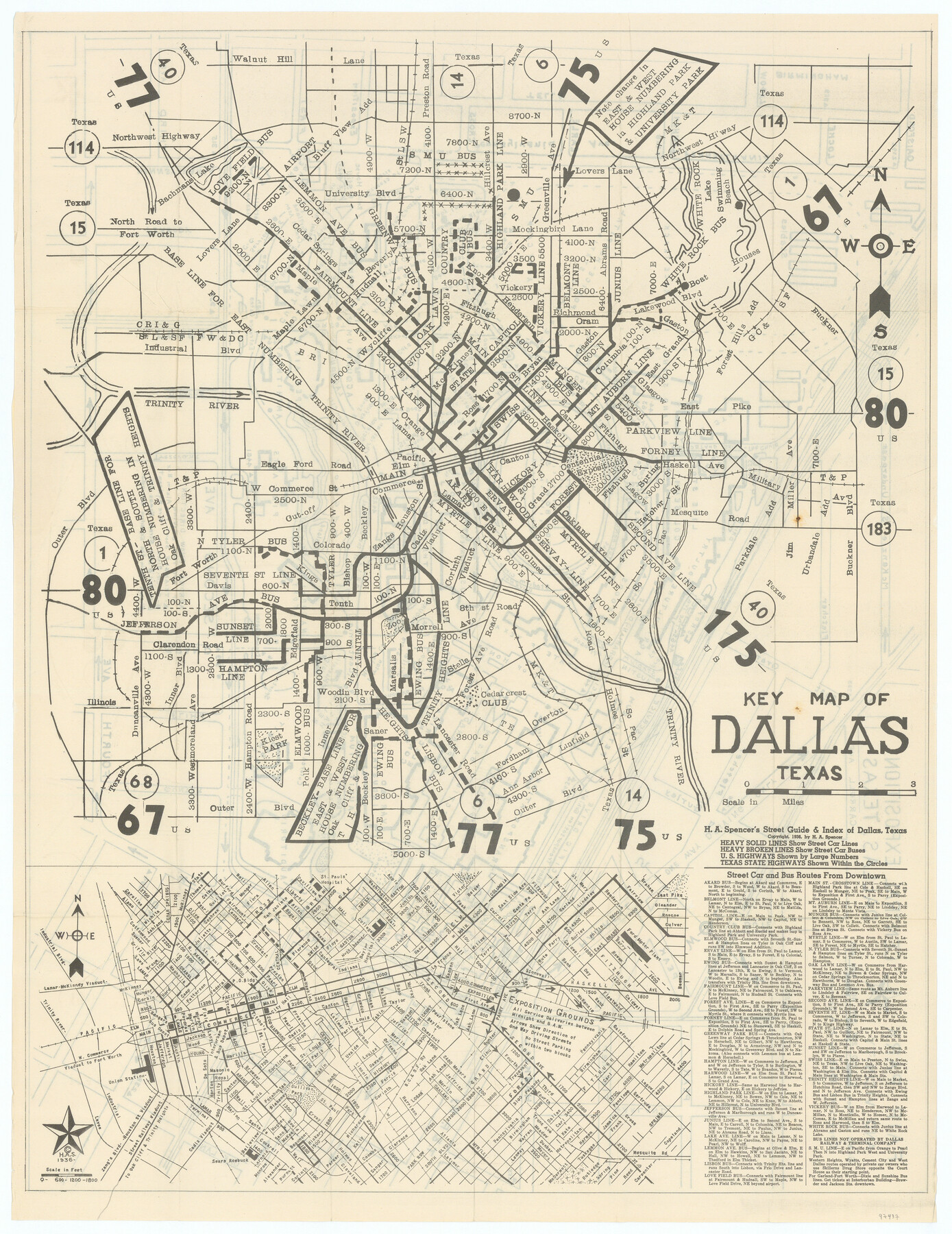
Key Map of Dallas, Texas
H.A. Spencer's Street Guide & Index of Dallas, Texas
-
Map/Doc
97437
-
Collection
General Map Collection
-
Object Dates
1936 (Creation Date)
-
People and Organizations
H.A. Spencer (Publisher)
-
Counties
Dallas
-
Subjects
City
-
Height x Width
22.5 x 17.4 inches
57.2 x 44.2 cm
-
Comments
See 97438 for map of Fair Park on verso.
To view and download the booklet in which this map was folded, please click the "Download PDF" link above.
Copyrighted and unavailable for duplication. Posted for research only.
Related maps

Part of: General Map Collection
Galveston Bay, Texas

Print $20.00
- Digital $50.00
Galveston Bay, Texas
1905
Size 24.8 x 18.5 inches
Map/Doc 65390
Pecos County Rolled Sketch 25 1/2

Print $20.00
- Digital $50.00
Pecos County Rolled Sketch 25 1/2
1888
Size 41.9 x 39.2 inches
Map/Doc 9688
[Aransas County, Texas]
![2083, [Aransas County, Texas], General Map Collection](https://historictexasmaps.com/wmedia_w700/maps/2083.tif.jpg)
Print $20.00
- Digital $50.00
[Aransas County, Texas]
1928
Size 37.5 x 31.3 inches
Map/Doc 2083
Terry County Working Sketch 4

Print $20.00
- Digital $50.00
Terry County Working Sketch 4
Size 24.9 x 29.6 inches
Map/Doc 62109
Newton County Sketch File 24

Print $4.00
- Digital $50.00
Newton County Sketch File 24
1881
Size 8.4 x 8.1 inches
Map/Doc 32405
Red River County Sketch File 5a

Print $2.00
- Digital $50.00
Red River County Sketch File 5a
Size 4.7 x 6.6 inches
Map/Doc 35104
Terrell County Sketch File 27

Print $10.00
- Digital $50.00
Terrell County Sketch File 27
1936
Size 8.7 x 11.3 inches
Map/Doc 37971

Tyler County Rolled Sketch 7

Print $20.00
- Digital $50.00
Tyler County Rolled Sketch 7
1960
Size 40.0 x 46.5 inches
Map/Doc 10030

Mills County Boundary File 9

Print $40.00
- Digital $50.00
Mills County Boundary File 9
Size 13.7 x 8.6 inches
Map/Doc 57318
Zapata County Working Sketch 12

Print $20.00
- Digital $50.00
Zapata County Working Sketch 12
Size 30.8 x 24.4 inches
Map/Doc 62063
You may also like
Gregg County Working Sketch 23

Print $20.00
- Digital $50.00
Gregg County Working Sketch 23
1982
Size 20.2 x 42.2 inches
Map/Doc 63290
Edwards County Working Sketch 30

Print $20.00
- Digital $50.00
Edwards County Working Sketch 30
1947
Size 27.7 x 38.2 inches
Map/Doc 68906
Map of Somervell County

Print $20.00
- Digital $50.00
Map of Somervell County
1875
Size 21.0 x 22.0 inches
Map/Doc 4043
Yates Pool, Pecos County, Texas

Print $3.00
- Digital $50.00
Yates Pool, Pecos County, Texas
1928
Size 11.5 x 10.3 inches
Map/Doc 91674
Map Prepared from Data in Original Field Book by W.D. Twichell

Print $40.00
- Digital $50.00
Map Prepared from Data in Original Field Book by W.D. Twichell
Size 64.2 x 39.9 inches
Map/Doc 89750
Runnels County Rolled Sketch 37

Print $20.00
- Digital $50.00
Runnels County Rolled Sketch 37
Size 37.8 x 38.2 inches
Map/Doc 9870
[Gulf, Colorado & Santa Fe]
![64592, [Gulf, Colorado & Santa Fe], General Map Collection](https://historictexasmaps.com/wmedia_w700/maps/64592.tif.jpg)
Print $40.00
- Digital $50.00
[Gulf, Colorado & Santa Fe]
1918
Size 33.2 x 110.5 inches
Map/Doc 64592
Crockett County Rolled Sketch 98

Print $40.00
- Digital $50.00
Crockett County Rolled Sketch 98
2021
Size 36.5 x 48.3 inches
Map/Doc 96577
[Map showing Block 35, Townships 1N-5N]
![93207, [Map showing Block 35, Townships 1N-5N], Twichell Survey Records](https://historictexasmaps.com/wmedia_w700/maps/93207-1.tif.jpg)
Print $40.00
- Digital $50.00
[Map showing Block 35, Townships 1N-5N]
Size 22.8 x 83.0 inches
Map/Doc 93207
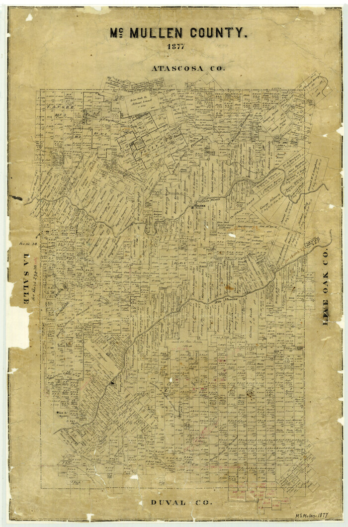
McMullen County
Print $20.00
- Digital $50.00
McMullen County
1877
Size 26.1 x 17.2 inches
Map/Doc 3867
Val Verde County Rolled Sketch 72A

Print $20.00
- Digital $50.00
Val Verde County Rolled Sketch 72A
Size 15.5 x 37.8 inches
Map/Doc 8135
Map of the reconnaissance in Texas by Lieuts Blake & Meade of the Corps of Topl. Engs.

Print $20.00
- Digital $50.00
Map of the reconnaissance in Texas by Lieuts Blake & Meade of the Corps of Topl. Engs.
1846
Size 27.1 x 22.5 inches
Map/Doc 2003