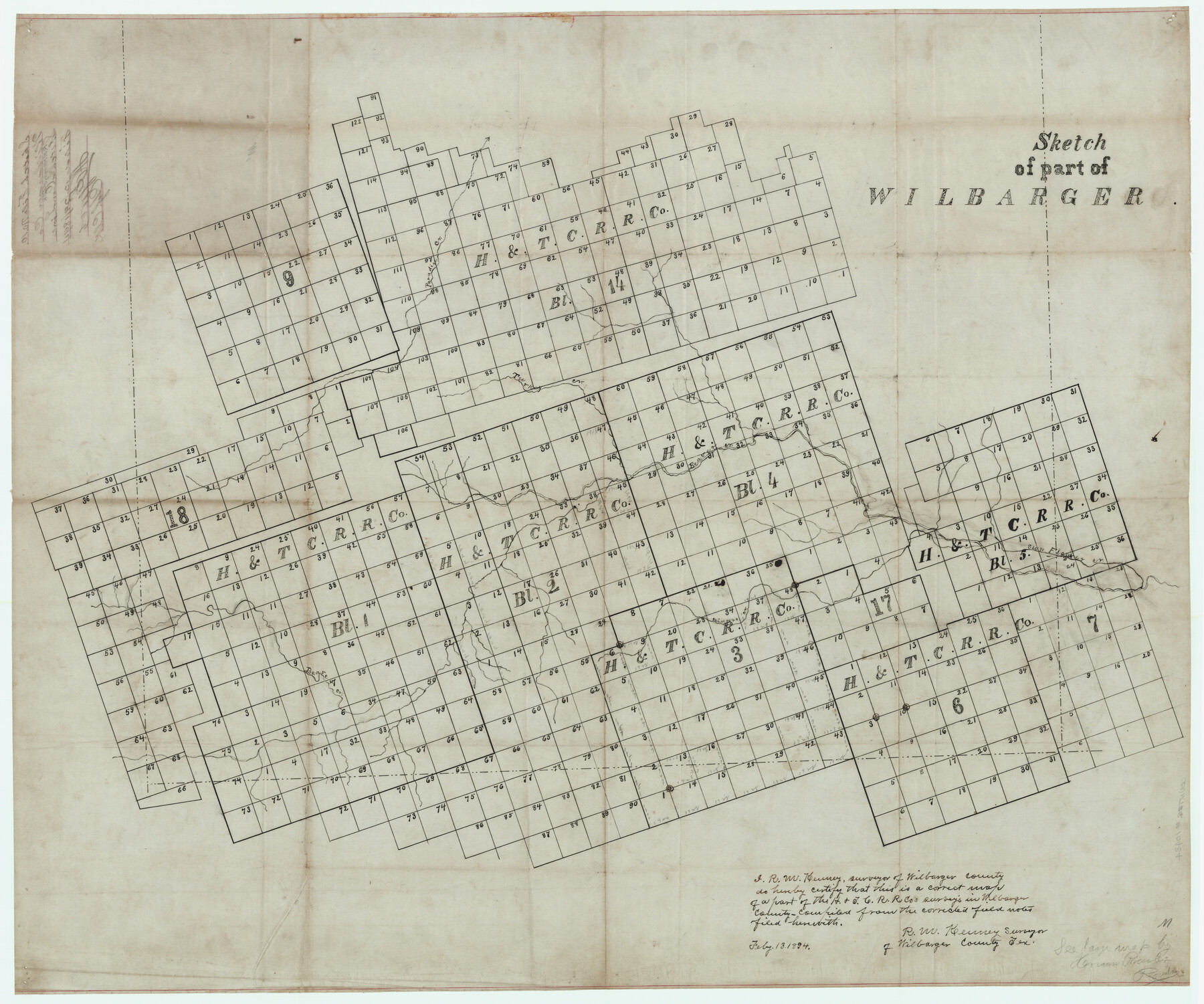
Wilbarger County Sketch File 10
[Sketch of H. & T. C. R.R. Co. Blocks in the south half of the county]
-
Map/Doc
10434
-
Collection
General Map Collection
-
Object Dates
2/13/1894 (Creation Date)
12/29/1894 (File Date)
-
People and Organizations
R.M. Kenney (Surveyor/Engineer)
-
Counties
Wilbarger Wichita Baylor Foard
-
Subjects
Surveying Sketch File
-
Height x Width
33.9 x 38.7 inches
86.1 x 98.3 cm
-
Medium
paper, manuscript
-
Features
Paradise Creek
Turkey Creek
Sun Flower Creek
Beaver Creek
Part of: General Map Collection
9th Street & Ave. A. Galveston, Texas showing beginning of jetty right of way, and seawall extension track

Print $20.00
- Digital $50.00
9th Street & Ave. A. Galveston, Texas showing beginning of jetty right of way, and seawall extension track
1920
Size 21.3 x 33.6 inches
Map/Doc 73630
Flight Mission No. BRE-2P, Frame 122, Nueces County

Print $20.00
- Digital $50.00
Flight Mission No. BRE-2P, Frame 122, Nueces County
1956
Size 18.4 x 22.4 inches
Map/Doc 86798
Map of east part of West Bay & SW part of Galveston Bay, Galveston County showing subdivision for mineral development

Print $20.00
- Digital $50.00
Map of east part of West Bay & SW part of Galveston Bay, Galveston County showing subdivision for mineral development
1951
Size 32.6 x 37.6 inches
Map/Doc 2975
Galveston Bay from a Spanish M. S.

Print $20.00
- Digital $50.00
Galveston Bay from a Spanish M. S.
1846
Size 25.1 x 18.2 inches
Map/Doc 72759
Presidio County Sketch File F

Print $2.00
- Digital $50.00
Presidio County Sketch File F
Size 15.5 x 8.2 inches
Map/Doc 34428
Harris County Historic Topographic 29

Print $20.00
- Digital $50.00
Harris County Historic Topographic 29
1915
Size 29.1 x 23.0 inches
Map/Doc 65840
La Salle County Sketch File 51

Print $20.00
- Digital $50.00
La Salle County Sketch File 51
1984
Size 13.4 x 20.5 inches
Map/Doc 11990
North Part of El Paso Co.

Print $20.00
- Digital $50.00
North Part of El Paso Co.
1977
Size 35.7 x 46.3 inches
Map/Doc 73141
Brazoria County Rolled Sketch 36

Print $20.00
- Digital $50.00
Brazoria County Rolled Sketch 36
Size 18.5 x 25.0 inches
Map/Doc 5172
Eastland County

Print $20.00
- Digital $50.00
Eastland County
1945
Size 44.4 x 43.7 inches
Map/Doc 95486
Randall County Working Sketch 3

Print $40.00
- Digital $50.00
Randall County Working Sketch 3
1934
Size 48.8 x 42.5 inches
Map/Doc 71840
Duval County Sketch File 52

Print $20.00
- Digital $50.00
Duval County Sketch File 52
1936
Size 21.0 x 28.6 inches
Map/Doc 11402
You may also like
Cameron County Sketch File 15

Print $26.00
- Digital $50.00
Cameron County Sketch File 15
1999
Size 11.2 x 8.7 inches
Map/Doc 17320
Kinney County Rolled Sketch 1

Print $20.00
- Digital $50.00
Kinney County Rolled Sketch 1
Size 25.1 x 36.1 inches
Map/Doc 6533
Bandera County Sketch File 23

Print $40.00
- Digital $50.00
Bandera County Sketch File 23
1881
Size 16.1 x 13.7 inches
Map/Doc 10895
Pecos County Working Sketch 109

Print $40.00
- Digital $50.00
Pecos County Working Sketch 109
1972
Size 34.8 x 56.9 inches
Map/Doc 71582
[T. J. Chambers' grant]
![319, [T. J. Chambers' grant], General Map Collection](https://historictexasmaps.com/wmedia_w700/maps/319.tif.jpg)
Print $2.00
- Digital $50.00
[T. J. Chambers' grant]
1847
Size 7.1 x 7.1 inches
Map/Doc 319
[Map of San Antonio, Texas]
![93399, [Map of San Antonio, Texas], General Map Collection - 1](https://historictexasmaps.com/wmedia_w700/maps/93399.tif.jpg)
Print $20.00
- Digital $50.00
[Map of San Antonio, Texas]
1895
Size 29.4 x 34.5 inches
Map/Doc 93399
Menard County Rolled Sketch 16

Print $20.00
- Digital $50.00
Menard County Rolled Sketch 16
1983
Size 29.8 x 36.6 inches
Map/Doc 6762
Hall County Sketch File 15

Print $6.00
- Digital $50.00
Hall County Sketch File 15
Size 5.7 x 16.9 inches
Map/Doc 24814
[Tie Line, Zavala County School Land to North Line of Block D11, East and South to Double Lakes Corner]
![91868, [Tie Line, Zavala County School Land to North Line of Block D11, East and South to Double Lakes Corner], Twichell Survey Records](https://historictexasmaps.com/wmedia_w700/maps/91868-1.tif.jpg)
Print $20.00
- Digital $50.00
[Tie Line, Zavala County School Land to North Line of Block D11, East and South to Double Lakes Corner]
1900
Size 18.5 x 12.6 inches
Map/Doc 91868
Map of the Surveyed Part of Young District

Print $40.00
- Digital $50.00
Map of the Surveyed Part of Young District
1860
Size 56.2 x 54.7 inches
Map/Doc 1986
Morris County Rolled Sketch 2A

Print $20.00
- Digital $50.00
Morris County Rolled Sketch 2A
Size 24.1 x 18.9 inches
Map/Doc 10261
Map of Texas and Pacific Ry. Company's Surveys in the 80 Mile Reserve

Print $40.00
- Digital $50.00
Map of Texas and Pacific Ry. Company's Surveys in the 80 Mile Reserve
1885
Map/Doc 2241