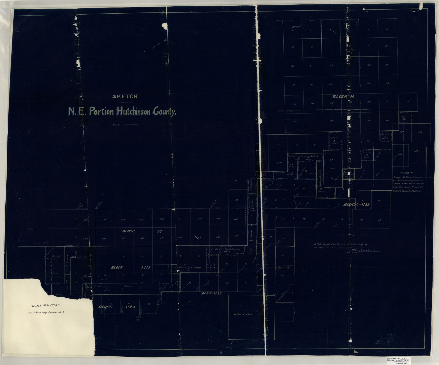
Hutchinson County Sketch File 20m
Sketch N.E. Portion Hutchinson County
-
Map/Doc
10501
-
Collection
General Map Collection
-
People and Organizations
W.D. Twichell (Surveyor/Engineer)
-
Counties
Hutchinson Hansford Ochiltree Roberts
-
Subjects
Surveying Sketch File
-
Height x Width
36.2 x 43.6 inches
92.0 x 110.7 cm
-
Medium
blueprint/diazo
-
Scale
1" = 1000 varas
Part of: General Map Collection
Boundary Between the United States & Mexico Agreed Upon by the Joint Commission under the Treaty of Guadalupe Hidalgo

Print $4.00
- Digital $50.00
Boundary Between the United States & Mexico Agreed Upon by the Joint Commission under the Treaty of Guadalupe Hidalgo
1853
Size 24.4 x 18.8 inches
Map/Doc 65395
Howard County Rolled Sketch 2

Print $20.00
- Digital $50.00
Howard County Rolled Sketch 2
1905
Size 27.6 x 23.0 inches
Map/Doc 6232
Township 2 North Range 12 West, North Western District, Louisiana

Print $20.00
- Digital $50.00
Township 2 North Range 12 West, North Western District, Louisiana
1884
Size 19.6 x 24.7 inches
Map/Doc 65875
Runnels County Sketch File 33

Print $20.00
Runnels County Sketch File 33
1892
Size 19.1 x 23.1 inches
Map/Doc 12264
Sabine County Working Sketch 10

Print $20.00
- Digital $50.00
Sabine County Working Sketch 10
1925
Size 18.6 x 24.2 inches
Map/Doc 63681
United States - Gulf Coast - From Latitude 26° 33' to the Rio Grande Texas

Print $20.00
- Digital $50.00
United States - Gulf Coast - From Latitude 26° 33' to the Rio Grande Texas
1918
Size 27.1 x 18.4 inches
Map/Doc 72852
Scurry County Working Sketch Graphic Index

Print $20.00
- Digital $50.00
Scurry County Working Sketch Graphic Index
1921
Size 39.9 x 37.0 inches
Map/Doc 76695
Leon County Sketch File 3

Print $4.00
- Digital $50.00
Leon County Sketch File 3
Size 12.4 x 7.9 inches
Map/Doc 29713
City of Austin, Texas - Height and Area adopted by City Council

Print $20.00
- Digital $50.00
City of Austin, Texas - Height and Area adopted by City Council
Size 42.5 x 28.6 inches
Map/Doc 95712
Val Verde County Sketch File Z5

Print $20.00
- Digital $50.00
Val Verde County Sketch File Z5
Size 32.3 x 26.1 inches
Map/Doc 12551
Brooks County Sketch File 3a

Print $5.00
- Digital $50.00
Brooks County Sketch File 3a
Size 14.2 x 9.5 inches
Map/Doc 16542
Brewster County Rolled Sketch 92

Print $20.00
- Digital $50.00
Brewster County Rolled Sketch 92
1950
Size 24.3 x 15.2 inches
Map/Doc 5250
You may also like
Map of Starr County State of Texas

Print $20.00
- Digital $50.00
Map of Starr County State of Texas
1911
Size 25.1 x 23.2 inches
Map/Doc 4048
Armstrong County Sketch File 2

Print $40.00
- Digital $50.00
Armstrong County Sketch File 2
Size 21.5 x 40.0 inches
Map/Doc 10371
General Highway Map, Floyd County, Texas

Print $20.00
General Highway Map, Floyd County, Texas
1940
Size 25.1 x 18.7 inches
Map/Doc 79091
Yoakum County Rolled Sketch 5

Print $20.00
- Digital $50.00
Yoakum County Rolled Sketch 5
1992
Size 20.9 x 16.3 inches
Map/Doc 8290

Blanco County Working Sketch 38

Print $40.00
- Digital $50.00
Blanco County Working Sketch 38
1984
Size 57.8 x 43.1 inches
Map/Doc 67398
Presidio County Boundary File 1a

Print $80.00
- Digital $50.00
Presidio County Boundary File 1a
Size 50.2 x 14.9 inches
Map/Doc 58052
McLennan County Sketch File 25

Print $2.00
- Digital $50.00
McLennan County Sketch File 25
Size 8.8 x 12.3 inches
Map/Doc 31299
Fisher County

Print $40.00
- Digital $50.00
Fisher County
1944
Size 50.2 x 44.2 inches
Map/Doc 95497
Caldwell County Sketch File 4b

Print $8.00
- Digital $50.00
Caldwell County Sketch File 4b
1896
Size 6.4 x 3.8 inches
Map/Doc 35839
Jeff Davis County Working Sketch 32

Print $40.00
- Digital $50.00
Jeff Davis County Working Sketch 32
1975
Size 66.7 x 43.7 inches
Map/Doc 66527
Johnson County Sketch File 10a

Print $4.00
- Digital $50.00
Johnson County Sketch File 10a
1877
Size 6.7 x 10.6 inches
Map/Doc 28445