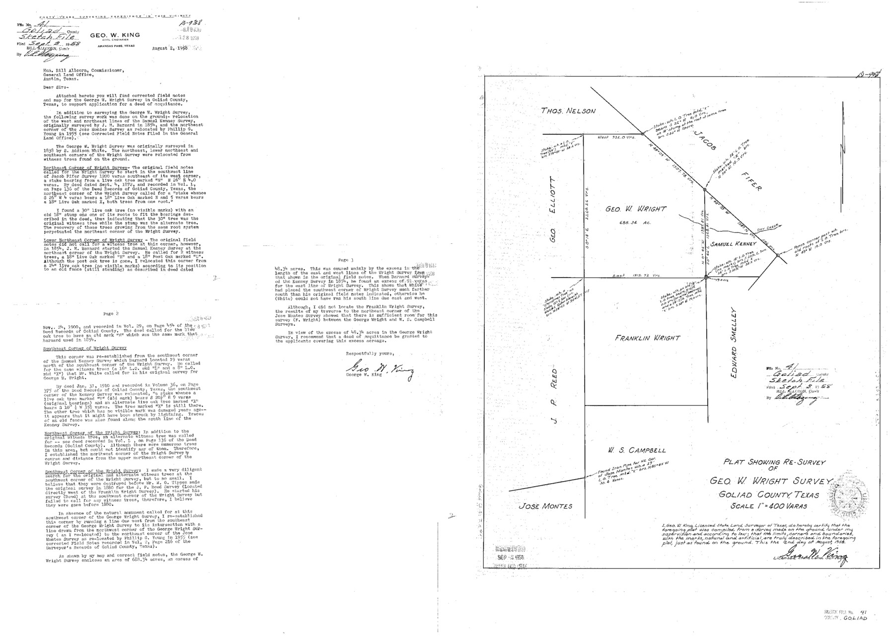
Goliad County Sketch File 41
Plat Showing Re-Survey of Geo. W. Wright Survey Goliad County, Texas
-
Map/Doc
11573
-
Collection
General Map Collection
-
Object Dates
1958/8/2 (Creation Date)
1958/9/3 (File Date)
1854 (Survey Date)
1955 (Survey Date)
1838 (Survey Date)
1880 (Survey Date)
-
People and Organizations
George W. King (Surveyor/Engineer)
J.H. Barnard (Surveyor/Engineer)
Phillip G. Young (Surveyor/Engineer)
S. Addison White (Surveyor/Engineer)
M.G. Tippen (Surveyor/Engineer)
-
Counties
Goliad
-
Subjects
Surveying Sketch File
-
Height x Width
25.2 x 35.3 inches
64.0 x 89.7 cm
-
Medium
paper, print
-
Scale
1:400
-
Features
Dry Creek
Part of: General Map Collection
Flight Mission No. DCL-7C, Frame 60, Kenedy County

Print $20.00
- Digital $50.00
Flight Mission No. DCL-7C, Frame 60, Kenedy County
1943
Size 15.3 x 15.3 inches
Map/Doc 86048
Wichita County Working Sketch 27

Print $20.00
- Digital $50.00
Wichita County Working Sketch 27
1984
Size 35.6 x 34.6 inches
Map/Doc 72537
Right of Way and Track Map International & Gt. Northern Ry. operated by the International & Gt. Northern Ry. Co., Gulf Division, Columbia Branch

Print $40.00
- Digital $50.00
Right of Way and Track Map International & Gt. Northern Ry. operated by the International & Gt. Northern Ry. Co., Gulf Division, Columbia Branch
1917
Size 24.9 x 56.5 inches
Map/Doc 64594
Tom Green County Rolled Sketch 22

Print $20.00
- Digital $50.00
Tom Green County Rolled Sketch 22
1966
Size 38.0 x 43.6 inches
Map/Doc 10006
Map of Calhoun County

Print $20.00
- Digital $50.00
Map of Calhoun County
1863
Size 23.0 x 19.5 inches
Map/Doc 887
Hansford County Sketch File 10

Print $6.00
- Digital $50.00
Hansford County Sketch File 10
1931
Size 8.2 x 8.5 inches
Map/Doc 24969
Jeff Davis County Rolled Sketch 20

Print $20.00
- Digital $50.00
Jeff Davis County Rolled Sketch 20
1944
Size 22.7 x 19.6 inches
Map/Doc 7724
Presidio County Sketch File 72

Print $6.00
- Digital $50.00
Presidio County Sketch File 72
1943
Size 13.3 x 8.8 inches
Map/Doc 34679
Texas Coordinate File 8

Print $4.00
- Digital $50.00
Texas Coordinate File 8
Size 11.3 x 8.7 inches
Map/Doc 75318
Erath County Sketch File A

Print $4.00
- Digital $50.00
Erath County Sketch File A
Size 8.6 x 11.0 inches
Map/Doc 22249
Houston Dis. Cochino Bayou

Print $2.00
- Digital $50.00
Houston Dis. Cochino Bayou
1847
Size 11.3 x 8.2 inches
Map/Doc 184

You may also like
[Dallam County Map]
![93157, [Dallam County Map], Twichell Survey Records](https://historictexasmaps.com/wmedia_w700/maps/93157-1.tif.jpg)
Print $40.00
- Digital $50.00
[Dallam County Map]
Size 51.1 x 65.2 inches
Map/Doc 93157
Carte d'Amerique, Divisee en ses Principaux Pays, Dressee sur les Memoires les plus recents, et sur differents Voyages, et assujettie aux observations Astronomiques de Mrs. de l'Academie Royale des Sciences

Print $40.00
- Digital $50.00
Carte d'Amerique, Divisee en ses Principaux Pays, Dressee sur les Memoires les plus recents, et sur differents Voyages, et assujettie aux observations Astronomiques de Mrs. de l'Academie Royale des Sciences
1787
Size 43.5 x 51.3 inches
Map/Doc 96430
Pecos County Rolled Sketch 136

Print $20.00
- Digital $50.00
Pecos County Rolled Sketch 136
1952
Size 24.7 x 17.6 inches
Map/Doc 7272
[Surveys in the Jefferson District: G. A. Patillo's league, Big Sandy, Sabine Bay]
![69727, [Surveys in the Jefferson District: G. A. Patillo's league, Big Sandy, Sabine Bay], General Map Collection](https://historictexasmaps.com/wmedia_w700/maps/69727-1.tif.jpg)
Print $20.00
- Digital $50.00
[Surveys in the Jefferson District: G. A. Patillo's league, Big Sandy, Sabine Bay]
1846
Size 14.4 x 20.9 inches
Map/Doc 69727
Marion County Rolled Sketch 9B

Print $20.00
- Digital $50.00
Marion County Rolled Sketch 9B
2001
Size 22.5 x 22.4 inches
Map/Doc 76420
Nueces County Rolled Sketch 100

Print $20.00
- Digital $50.00
Nueces County Rolled Sketch 100
Size 30.6 x 40.7 inches
Map/Doc 10209
J. H. Colton's map of the state of Louisiana and eastern part of Texas compiled from United States Surveys, and other authentic sources, showing the counties, townships, sections. Fractional sections, settlement rights, railroads, &c.

Print $20.00
J. H. Colton's map of the state of Louisiana and eastern part of Texas compiled from United States Surveys, and other authentic sources, showing the counties, townships, sections. Fractional sections, settlement rights, railroads, &c.
1863
Size 35.8 x 43.3 inches
Map/Doc 93603
[Edwards Co.]
![66811, [Edwards Co.], General Map Collection](https://historictexasmaps.com/wmedia_w700/maps/66811.tif.jpg)
Print $20.00
- Digital $50.00
[Edwards Co.]
1910
Size 38.8 x 36.2 inches
Map/Doc 66811
Hall County Sketch File 35

Print $22.00
- Digital $50.00
Hall County Sketch File 35
1913
Size 11.2 x 8.8 inches
Map/Doc 24884
Map Showing Lands Surveyed for Tom Pinkston, W. D. Twichell and H. Y. Quarles in Stephens County, Texas

Print $20.00
- Digital $50.00
Map Showing Lands Surveyed for Tom Pinkston, W. D. Twichell and H. Y. Quarles in Stephens County, Texas
1919
Size 19.7 x 21.2 inches
Map/Doc 91892
Erath County Working Sketch 16

Print $20.00
- Digital $50.00
Erath County Working Sketch 16
1961
Size 20.9 x 26.5 inches
Map/Doc 69097
[Stone, Kyle and Kyle Block M6]
![90394, [Stone, Kyle and Kyle Block M6], Twichell Survey Records](https://historictexasmaps.com/wmedia_w700/maps/90394-1.tif.jpg)
Print $20.00
- Digital $50.00
[Stone, Kyle and Kyle Block M6]
Size 19.7 x 22.5 inches
Map/Doc 90394