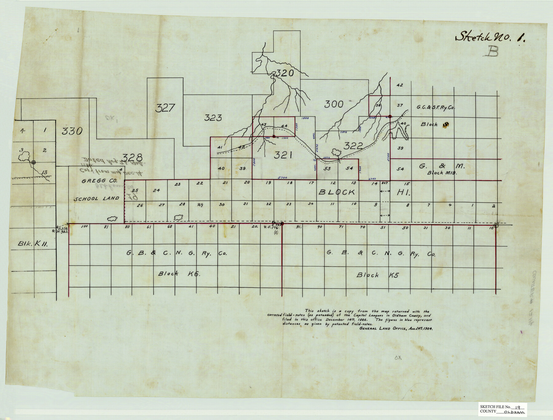
Oldham County Sketch File 19
[Sketch of Capitol Leagues northwest from Vega]
-
Map/Doc
12116
-
Collection
General Map Collection
-
Object Dates
8/24/1904 (Creation Date)
-
Counties
Oldham
-
Subjects
Surveying Sketch File
-
Height x Width
18.2 x 24.0 inches
46.2 x 61.0 cm
-
Medium
paper, manuscript
Part of: General Map Collection
Hudspeth County Rolled Sketch 74

Print $40.00
- Digital $50.00
Hudspeth County Rolled Sketch 74
1992
Size 49.5 x 38.1 inches
Map/Doc 9237
Brewster County Rolled Sketch 74

Print $20.00
- Digital $50.00
Brewster County Rolled Sketch 74
1941
Size 22.8 x 15.8 inches
Map/Doc 5240
Galveston County Boundary File 32a

Print $10.00
- Digital $50.00
Galveston County Boundary File 32a
Size 11.4 x 8.9 inches
Map/Doc 53666
Montague County Working Sketch 4

Print $20.00
- Digital $50.00
Montague County Working Sketch 4
1920
Size 25.3 x 22.0 inches
Map/Doc 71070
Callahan County Boundary File 1

Print $120.00
- Digital $50.00
Callahan County Boundary File 1
Size 14.2 x 8.6 inches
Map/Doc 51025
Wise County Sketch File 23

Print $4.00
- Digital $50.00
Wise County Sketch File 23
1859
Size 7.9 x 12.9 inches
Map/Doc 40568
Flight Mission No. CUG-3P, Frame 78, Kleberg County

Print $20.00
- Digital $50.00
Flight Mission No. CUG-3P, Frame 78, Kleberg County
1956
Size 18.5 x 22.2 inches
Map/Doc 86253
Val Verde County Sketch File F

Print $42.00
- Digital $50.00
Val Verde County Sketch File F
1906
Size 40.1 x 16.9 inches
Map/Doc 10423
Colton's "New Medium" Map of the State of Texas, the Indian Territory, etc. from the latest & most authentic sources

Print $20.00
- Digital $50.00
Colton's "New Medium" Map of the State of Texas, the Indian Territory, etc. from the latest & most authentic sources
1884
Size 25.4 x 29.5 inches
Map/Doc 96524
Flight Mission No. BRE-3P, Frame 97, Nueces County

Print $20.00
- Digital $50.00
Flight Mission No. BRE-3P, Frame 97, Nueces County
1956
Size 18.4 x 22.2 inches
Map/Doc 86828
Brewster County Sketch File C-1

Print $14.00
- Digital $50.00
Brewster County Sketch File C-1
1911
Size 11.2 x 8.9 inches
Map/Doc 15719
Aransas County Sketch File 14a

Print $40.00
- Digital $50.00
Aransas County Sketch File 14a
1891
Size 16.7 x 15.8 inches
Map/Doc 10821
You may also like
Flight Mission No. DQO-2K, Frame 143, Galveston County

Print $20.00
- Digital $50.00
Flight Mission No. DQO-2K, Frame 143, Galveston County
1952
Size 18.8 x 22.5 inches
Map/Doc 85040
Kent County Working Sketch 3a

Print $20.00
- Digital $50.00
Kent County Working Sketch 3a
1948
Size 24.5 x 18.6 inches
Map/Doc 70009
Harris County Rolled Sketch 88

Print $20.00
- Digital $50.00
Harris County Rolled Sketch 88
1937
Size 34.8 x 22.8 inches
Map/Doc 6127
Zavala County Rolled Sketch 31

Print $20.00
- Digital $50.00
Zavala County Rolled Sketch 31
1883
Size 37.4 x 27.1 inches
Map/Doc 8332
[Surveys in Austin's Colony by Horatio Chriesman along Mill and Cummins Creeks]
![68, [Surveys in Austin's Colony by Horatio Chriesman along Mill and Cummins Creeks], General Map Collection](https://historictexasmaps.com/wmedia_w700/maps/68.tif.jpg)
Print $20.00
- Digital $50.00
[Surveys in Austin's Colony by Horatio Chriesman along Mill and Cummins Creeks]
1830
Size 30.7 x 25.7 inches
Map/Doc 68
Presidio County Rolled Sketch 126

Print $20.00
- Digital $50.00
Presidio County Rolled Sketch 126
1986
Size 27.8 x 39.4 inches
Map/Doc 7397
Nolan County Working Sketch 1

Print $20.00
- Digital $50.00
Nolan County Working Sketch 1
1928
Size 17.9 x 17.5 inches
Map/Doc 71292
Hudspeth County Working Sketch 1

Print $40.00
- Digital $50.00
Hudspeth County Working Sketch 1
1911
Size 26.5 x 53.3 inches
Map/Doc 69023
Tarrant County Sketch File 27

Print $4.00
- Digital $50.00
Tarrant County Sketch File 27
Size 8.0 x 9.6 inches
Map/Doc 37741
Map of Capitol Leagues Situated in Hockley and Lamb Counties, Texas

Print $20.00
- Digital $50.00
Map of Capitol Leagues Situated in Hockley and Lamb Counties, Texas
Size 18.5 x 26.1 inches
Map/Doc 92205
Mills County Sketch File 18

Print $4.00
- Digital $50.00
Mills County Sketch File 18
1872
Size 12.1 x 8.1 inches
Map/Doc 31668
Ochiltree County

Print $20.00
- Digital $50.00
Ochiltree County
1908
Size 40.9 x 37.1 inches
Map/Doc 16782