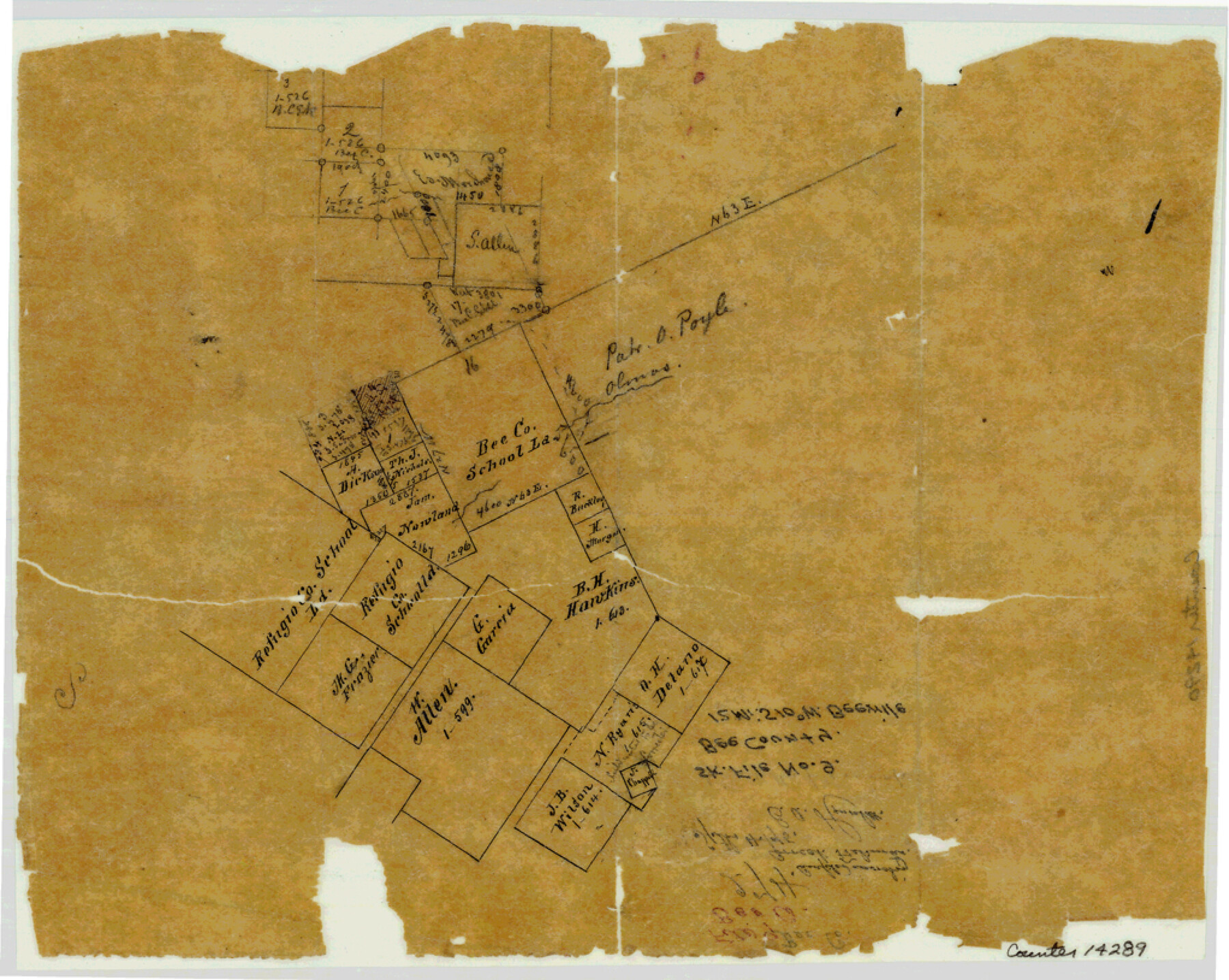
Bee County Sketch File 9
[Sketch of surveys around Bee County School Land southwest of Beeville]
-
Map/Doc
14289
-
Collection
General Map Collection
-
Object Dates
1875/9/4 (File Date)
-
Counties
Bee
-
Subjects
Surveying Sketch File
-
Height x Width
8.1 x 10.2 inches
20.6 x 25.9 cm
-
Medium
paper, manuscript
-
Features
Olmos Creek
Part of: General Map Collection
Flight Mission No. CLL-1N, Frame 34, Willacy County

Print $20.00
- Digital $50.00
Flight Mission No. CLL-1N, Frame 34, Willacy County
1954
Size 18.4 x 22.2 inches
Map/Doc 87015
St. L. S-W. Ry. of Texas Map of Lufkin Branch in Cherokee County Texas

Print $40.00
- Digital $50.00
St. L. S-W. Ry. of Texas Map of Lufkin Branch in Cherokee County Texas
1912
Size 23.4 x 121.6 inches
Map/Doc 64016
Edwards County Working Sketch 74

Print $20.00
- Digital $50.00
Edwards County Working Sketch 74
1959
Size 23.6 x 38.4 inches
Map/Doc 68950
Gregg County Working Sketch 21

Print $20.00
- Digital $50.00
Gregg County Working Sketch 21
1966
Size 25.5 x 32.1 inches
Map/Doc 63288
[Surveys in the Fannin District: Bois d'Arc Creek, Sulphur Creek]
![263, [Surveys in the Fannin District: Bois d'Arc Creek, Sulphur Creek], General Map Collection](https://historictexasmaps.com/wmedia_w700/maps/263.tif.jpg)
Print $2.00
- Digital $50.00
[Surveys in the Fannin District: Bois d'Arc Creek, Sulphur Creek]
1844
Size 7.9 x 7.9 inches
Map/Doc 263

Bosque County Working Sketch 33

Print $20.00
- Digital $50.00
Bosque County Working Sketch 33
2016
Size 37.0 x 25.0 inches
Map/Doc 93980
Coleman County

Print $20.00
- Digital $50.00
Coleman County
1862
Size 22.5 x 21.6 inches
Map/Doc 3414
Gulf Intracoastal Waterway - Aransas Bay to Corpus Christi Bay - Modified Route Main Channel

Print $20.00
- Digital $50.00
Gulf Intracoastal Waterway - Aransas Bay to Corpus Christi Bay - Modified Route Main Channel
1960
Size 31.3 x 42.7 inches
Map/Doc 61902
Jack County Working Sketch 3

Print $20.00
- Digital $50.00
Jack County Working Sketch 3
1940
Size 18.8 x 26.0 inches
Map/Doc 66429

Presidio County Working Sketch Graphic Index, South Part, Sheet 2 (Sketches 45 to Most Recent)

Print $20.00
- Digital $50.00
Presidio County Working Sketch Graphic Index, South Part, Sheet 2 (Sketches 45 to Most Recent)
1975
Size 32.4 x 37.9 inches
Map/Doc 76671
You may also like
San Saba County Sketch File 16

Print $20.00
- Digital $50.00
San Saba County Sketch File 16
1902
Size 16.9 x 18.8 inches
Map/Doc 12294
Flight Mission No. BQR-22K, Frame 46, Brazoria County

Print $20.00
- Digital $50.00
Flight Mission No. BQR-22K, Frame 46, Brazoria County
1953
Size 18.6 x 22.4 inches
Map/Doc 84130
Morris County Rolled Sketch 2A

Print $20.00
- Digital $50.00
Morris County Rolled Sketch 2A
Size 24.0 x 18.8 inches
Map/Doc 10257
Hall County Sketch File 14

Print $20.00
- Digital $50.00
Hall County Sketch File 14
1882
Size 20.9 x 32.9 inches
Map/Doc 11607
Childress County Boundary File 1

Print $2.00
- Digital $50.00
Childress County Boundary File 1
Size 8.9 x 3.8 inches
Map/Doc 51305
Leveland and Adjacent Subdivisions of League 28, Hood County School Land Hockley County, Texas

Print $40.00
- Digital $50.00
Leveland and Adjacent Subdivisions of League 28, Hood County School Land Hockley County, Texas
Size 42.4 x 50.4 inches
Map/Doc 89848
Jack County Sketch File 13

Print $4.00
- Digital $50.00
Jack County Sketch File 13
Size 10.3 x 8.0 inches
Map/Doc 27537
Refugio County Sketch File 7

Print $4.00
- Digital $50.00
Refugio County Sketch File 7
1875
Size 12.1 x 7.6 inches
Map/Doc 35251
Lubbock Irrigation Co. San Augustine County School Land Lubbock County, Texas

Print $20.00
- Digital $50.00
Lubbock Irrigation Co. San Augustine County School Land Lubbock County, Texas
Size 37.5 x 37.9 inches
Map/Doc 89894
Shelby County Working Sketch 29

Print $20.00
- Digital $50.00
Shelby County Working Sketch 29
2000
Size 19.6 x 29.9 inches
Map/Doc 63883
[Old Coastal Chart of Texas Coast showing passes with depth readings]
![4662, [Old Coastal Chart of Texas Coast showing passes with depth readings], General Map Collection](https://historictexasmaps.com/wmedia_w700/maps/4662-1.tif.jpg)
Print $40.00
- Digital $50.00
[Old Coastal Chart of Texas Coast showing passes with depth readings]
Size 25.4 x 48.6 inches
Map/Doc 4662
Right of Way and Track Map International & Gt Northern Ry. operated by the International & Gt. Northern Ry. Co., San Antonio Division

Print $40.00
- Digital $50.00
Right of Way and Track Map International & Gt Northern Ry. operated by the International & Gt. Northern Ry. Co., San Antonio Division
1917
Size 26.2 x 58.6 inches
Map/Doc 64788