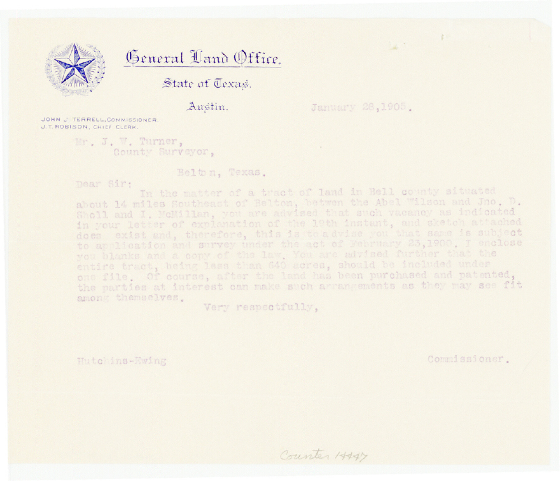
Bell County Sketch File 32
[Surveyor's sketch and statement regarding surveys on Little River]
-
Map/Doc
14447
-
Collection
General Map Collection
-
Object Dates
1905/1/19 (Creation Date)
-
People and Organizations
J.W. Turner (Surveyor/Engineer)
-
Counties
Bell
-
Subjects
Surveying Sketch File
-
Height x Width
7.6 x 8.8 inches
19.3 x 22.4 cm
-
Medium
multi-page, multi-format
-
Features
Little River
Branch [Creek]
Part of: General Map Collection
Flight Mission No. CUG-1P, Frame 171, Kleberg County

Print $20.00
- Digital $50.00
Flight Mission No. CUG-1P, Frame 171, Kleberg County
1956
Size 18.5 x 22.1 inches
Map/Doc 86178
Hidalgo County Working Sketch 8

Print $40.00
- Digital $50.00
Hidalgo County Working Sketch 8
1963
Size 25.7 x 72.8 inches
Map/Doc 66185
Hutchinson County Sketch File 15

Print $20.00
- Digital $50.00
Hutchinson County Sketch File 15
Size 20.7 x 26.7 inches
Map/Doc 11813
Walker County Working Sketch 19

Print $3.00
- Digital $50.00
Walker County Working Sketch 19
Size 9.3 x 16.1 inches
Map/Doc 72299
Burleson County Working Sketch 27

Print $20.00
- Digital $50.00
Burleson County Working Sketch 27
1981
Size 23.8 x 12.2 inches
Map/Doc 67746
Brazos Santiago, Texas

Print $20.00
- Digital $50.00
Brazos Santiago, Texas
1867
Size 25.1 x 18.3 inches
Map/Doc 72988
Flight Mission No. CUG-1P, Frame 103, Kleberg County

Print $20.00
- Digital $50.00
Flight Mission No. CUG-1P, Frame 103, Kleberg County
1956
Size 18.5 x 22.6 inches
Map/Doc 86153
Flight Mission No. CRC-4R, Frame 184, Chambers County

Print $20.00
- Digital $50.00
Flight Mission No. CRC-4R, Frame 184, Chambers County
1956
Size 18.6 x 22.3 inches
Map/Doc 84935
Dallas County Boundary File 9

Print $6.00
- Digital $50.00
Dallas County Boundary File 9
2008
Map/Doc 88850
Map of Mexico and Central America engraved to illustrate Mitchell's new intermediate geography

Print $20.00
- Digital $50.00
Map of Mexico and Central America engraved to illustrate Mitchell's new intermediate geography
1885
Size 9.0 x 12.2 inches
Map/Doc 93523
Bowie County Working Sketch 17

Print $20.00
- Digital $50.00
Bowie County Working Sketch 17
1962
Size 24.5 x 20.0 inches
Map/Doc 67421
Hunt County Rolled Sketch 1

Print $20.00
- Digital $50.00
Hunt County Rolled Sketch 1
Size 28.3 x 18.4 inches
Map/Doc 6266
You may also like
Bell County, Texas

Print $20.00
- Digital $50.00
Bell County, Texas
1879
Size 23.7 x 29.0 inches
Map/Doc 516
San Patricio County Working Sketch 9

Print $40.00
- Digital $50.00
San Patricio County Working Sketch 9
1937
Size 52.8 x 44.0 inches
Map/Doc 63771
Hutchinson County Rolled Sketch 8

Print $20.00
- Digital $50.00
Hutchinson County Rolled Sketch 8
Size 32.0 x 29.1 inches
Map/Doc 6279
Raymond Marshall Farm

Print $3.00
- Digital $50.00
Raymond Marshall Farm
Size 9.8 x 12.6 inches
Map/Doc 92310

Chambers County Sketch File 38

Print $20.00
- Digital $50.00
Chambers County Sketch File 38
Size 25.1 x 35.8 inches
Map/Doc 11068
Red River County Working Sketch 16

Print $20.00
- Digital $50.00
Red River County Working Sketch 16
1953
Size 21.8 x 23.4 inches
Map/Doc 71999
Flight Mission No. DIX-3P, Frame 133, Aransas County

Print $20.00
- Digital $50.00
Flight Mission No. DIX-3P, Frame 133, Aransas County
1956
Size 17.8 x 21.1 inches
Map/Doc 83763

"G" Sketch from Gaines County

Print $20.00
- Digital $50.00
"G" Sketch from Gaines County
1902
Size 31.7 x 21.7 inches
Map/Doc 90839
English Field Notes of the Spanish Archives - Book 3

English Field Notes of the Spanish Archives - Book 3
1835
Map/Doc 96529
Moore County Working Sketch 6

Print $20.00
- Digital $50.00
Moore County Working Sketch 6
1921
Size 16.0 x 14.5 inches
Map/Doc 71188