Blanco County Sketch File 51
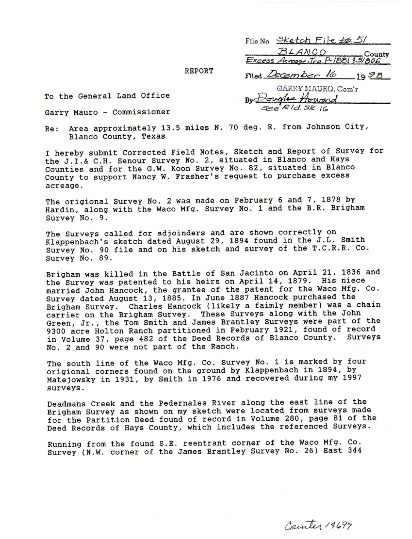
[Surveyor's report regarding excess acreage for the J.I. & C.H. Senour survey no. 2 and G.W. Koon survey no. 82]
-
Map/Doc
14697
-
Collection
General Map Collection
-
Object Dates
1998/8/14 (Creation Date)
1998/12/16 (File Date)
-
People and Organizations
Charles Ottmers (Surveyor/Engineer)
-
Counties
Blanco Hays
-
Subjects
Surveying Sketch File
-
Height x Width
11.1 x 8.5 inches
28.2 x 21.6 cm
-
Medium
paper, print
-
Comments
See Blanco County Rolled Sketch 16 (5152) for sketch.
-
Features
Holton Ranch
Deadmans Creek
Pedernales River
Related maps
Blanco County Rolled Sketch 16

Print $20.00
- Digital $50.00
Blanco County Rolled Sketch 16
Size 18.8 x 19.4 inches
Map/Doc 5152
Part of: General Map Collection
[Blanco County]
![3307, [Blanco County], General Map Collection](https://historictexasmaps.com/wmedia_w700/maps/3307-2.tif.jpg)
Print $20.00
- Digital $50.00
[Blanco County]
1872
Size 19.1 x 16.0 inches
Map/Doc 3307
Shelby County

Print $40.00
- Digital $50.00
Shelby County
1897
Size 43.9 x 49.3 inches
Map/Doc 16814
Old Miscellaneous File 32

Print $4.00
- Digital $50.00
Old Miscellaneous File 32
1854
Size 11.0 x 8.6 inches
Map/Doc 75751
Edwards County Sketch File 37

Print $4.00
- Digital $50.00
Edwards County Sketch File 37
1926
Size 11.3 x 9.0 inches
Map/Doc 21771
Liberty County Working Sketch 43

Print $20.00
- Digital $50.00
Liberty County Working Sketch 43
1953
Size 30.6 x 43.7 inches
Map/Doc 70502
McCulloch County Working Sketch 12

Print $20.00
- Digital $50.00
McCulloch County Working Sketch 12
1982
Size 37.5 x 20.1 inches
Map/Doc 70687
Brewster County Working Sketch 97

Print $20.00
- Digital $50.00
Brewster County Working Sketch 97
1978
Size 31.7 x 47.0 inches
Map/Doc 67697
Nueces County Sketch File 76

Print $54.00
- Digital $50.00
Nueces County Sketch File 76
1992
Size 11.0 x 8.6 inches
Map/Doc 33032
[San Antonio & Aransas Pass Railway Co.]
![64260, [San Antonio & Aransas Pass Railway Co.], General Map Collection](https://historictexasmaps.com/wmedia_w700/maps/64260.tif.jpg)
Print $20.00
- Digital $50.00
[San Antonio & Aransas Pass Railway Co.]
Size 18.5 x 29.4 inches
Map/Doc 64260
Presidio County Sketch File 37

Print $16.00
- Digital $50.00
Presidio County Sketch File 37
Size 14.3 x 8.7 inches
Map/Doc 34491
Matagorda County Sketch File 27

Print $60.00
- Digital $50.00
Matagorda County Sketch File 27
1908
Size 11.8 x 15.7 inches
Map/Doc 30803
McCulloch County Rolled Sketch 5

Print $20.00
- Digital $50.00
McCulloch County Rolled Sketch 5
Size 25.7 x 20.9 inches
Map/Doc 6716
You may also like
Liberty County Sketch File 36a

Print $4.00
- Digital $50.00
Liberty County Sketch File 36a
Size 8.6 x 5.6 inches
Map/Doc 29974
Northeast Part of Webb County

Print $40.00
- Digital $50.00
Northeast Part of Webb County
1986
Size 37.7 x 50.0 inches
Map/Doc 95668
[Surveys in Henderson County, Nacogdoches/Houston District]
![69735, [Surveys in Henderson County, Nacogdoches/Houston District], General Map Collection](https://historictexasmaps.com/wmedia_w700/maps/69735.tif.jpg)
Print $2.00
- Digital $50.00
[Surveys in Henderson County, Nacogdoches/Houston District]
Size 11.0 x 7.9 inches
Map/Doc 69735

Text (Possibly Legislative) Describing the Boundaries of Washington County, Undated

Print $20.00
Text (Possibly Legislative) Describing the Boundaries of Washington County, Undated
2020
Size 20.0 x 21.7 inches
Map/Doc 96407
Stonewall County Working Sketch 4

Print $20.00
- Digital $50.00
Stonewall County Working Sketch 4
1919
Size 28.7 x 23.8 inches
Map/Doc 63998
Maps of Gulf Intracoastal Waterway, Texas - Sabine River to the Rio Grande and connecting waterways including ship channels

Print $20.00
- Digital $50.00
Maps of Gulf Intracoastal Waterway, Texas - Sabine River to the Rio Grande and connecting waterways including ship channels
1966
Size 14.4 x 20.6 inches
Map/Doc 61996
Right-of-Way and Track Map, Texas State Railroad operated by the T. and N. O. R.R. Co.

Print $40.00
- Digital $50.00
Right-of-Way and Track Map, Texas State Railroad operated by the T. and N. O. R.R. Co.
1917
Size 24.8 x 56.3 inches
Map/Doc 64173
Dimmit County Sketch File 24

Print $4.00
- Digital $50.00
Dimmit County Sketch File 24
1885
Size 13.0 x 8.7 inches
Map/Doc 21140
Irion County Rolled Sketch 23

Print $40.00
- Digital $50.00
Irion County Rolled Sketch 23
Size 42.9 x 49.1 inches
Map/Doc 10302
Galveston County NRC Article 33.136 Location Key Sheet

Print $20.00
- Digital $50.00
Galveston County NRC Article 33.136 Location Key Sheet
1994
Size 27.0 x 21.8 inches
Map/Doc 77024
Tarrant County Working Sketch 17

Print $20.00
- Digital $50.00
Tarrant County Working Sketch 17
1983
Size 24.6 x 20.7 inches
Map/Doc 62434