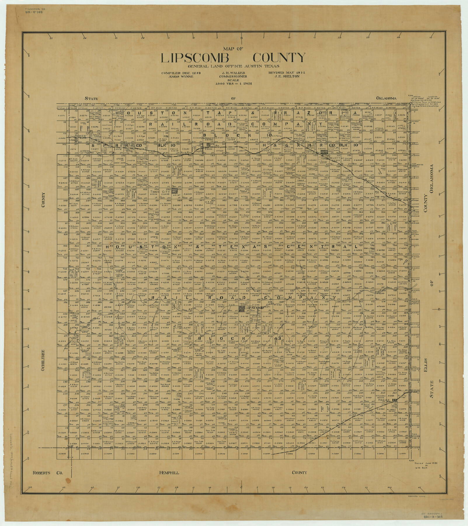
Map of Lipscomb County
RM-3-148
-
Map/Doc
1883
-
Collection
General Map Collection
-
Object Dates
12/1899 (Creation Date)
5/1932 (Revision Date)
6/1932 (Tracing Date)
-
People and Organizations
J.H. Walker (GLO Commissioner)
Amos Wynne (Compiler)
J.E. Shelton (Draftsman)
W.M. Beck (Tracer)
-
Counties
Lipscomb
-
Subjects
County
-
Height x Width
45.1 x 39.6 inches
114.6 x 100.6 cm
Part of: General Map Collection
Fisher County Working Sketch 5

Print $20.00
- Digital $50.00
Fisher County Working Sketch 5
1926
Size 23.0 x 25.6 inches
Map/Doc 69139
Map of Crockett Co.

Print $20.00
- Digital $50.00
Map of Crockett Co.
1894
Size 32.6 x 44.1 inches
Map/Doc 4725
Aransas County Rolled Sketch 27

Print $20.00
- Digital $50.00
Aransas County Rolled Sketch 27
1983
Size 24.9 x 35.4 inches
Map/Doc 5059
Cooke County Boundary File 1b

Print $28.00
- Digital $50.00
Cooke County Boundary File 1b
Size 12.6 x 7.4 inches
Map/Doc 51835
San Augustine Co.

Print $40.00
- Digital $50.00
San Augustine Co.
1949
Size 48.9 x 32.2 inches
Map/Doc 95632
Hood County Sketch File 7

Print $6.00
- Digital $50.00
Hood County Sketch File 7
Size 12.9 x 7.9 inches
Map/Doc 26581
Map of Brassos [sic] & Bosque Surveys
![146, Map of Brassos [sic] & Bosque Surveys, General Map Collection](https://historictexasmaps.com/wmedia_w700/maps/146.tif.jpg)
Print $20.00
- Digital $50.00
Map of Brassos [sic] & Bosque Surveys
1841
Size 27.7 x 18.9 inches
Map/Doc 146
Dimmit County Working Sketch Graphic Index - sheet B

Print $40.00
- Digital $50.00
Dimmit County Working Sketch Graphic Index - sheet B
1976
Size 41.5 x 49.9 inches
Map/Doc 76525
Leon County Rolled Sketch 27A

Print $40.00
- Digital $50.00
Leon County Rolled Sketch 27A
Size 50.5 x 47.8 inches
Map/Doc 9437
Corpus Christi Bay, Texas

Print $40.00
- Digital $50.00
Corpus Christi Bay, Texas
1867
Size 33.0 x 48.7 inches
Map/Doc 73467
Zapata County Working Sketch 22

Print $20.00
- Digital $50.00
Zapata County Working Sketch 22
1984
Size 31.8 x 40.1 inches
Map/Doc 62073
San Saba County Working Sketch 8

Print $20.00
- Digital $50.00
San Saba County Working Sketch 8
1979
Size 13.3 x 17.2 inches
Map/Doc 63796
You may also like
Sabine Pass and Lake

Print $20.00
- Digital $50.00
Sabine Pass and Lake
1958
Size 47.1 x 27.5 inches
Map/Doc 69823
Flight Mission No. DCL-3C, Frame 156, Kenedy County

Print $20.00
- Digital $50.00
Flight Mission No. DCL-3C, Frame 156, Kenedy County
1943
Size 18.5 x 22.3 inches
Map/Doc 85804
Brewster County Rolled Sketch 101

Print $40.00
- Digital $50.00
Brewster County Rolled Sketch 101
1927
Size 74.4 x 42.4 inches
Map/Doc 9196
Brewster County Working Sketch 39

Print $20.00
- Digital $50.00
Brewster County Working Sketch 39
1944
Size 26.8 x 37.5 inches
Map/Doc 67573
Anderson County Sketch File 16

Print $6.00
- Digital $50.00
Anderson County Sketch File 16
1849
Size 8.6 x 6.5 inches
Map/Doc 12783
Frio County Rolled Sketch 20

Print $40.00
- Digital $50.00
Frio County Rolled Sketch 20
1956
Size 31.0 x 59.4 inches
Map/Doc 8910
Morris County Rolled Sketch 2A

Print $20.00
- Digital $50.00
Morris County Rolled Sketch 2A
Size 36.7 x 25.1 inches
Map/Doc 10259
Llano County Sketch File 4

Print $6.00
- Digital $50.00
Llano County Sketch File 4
1869
Size 12.4 x 8.0 inches
Map/Doc 30353
Flight Mission No. BRA-6M, Frame 73, Jefferson County

Print $20.00
- Digital $50.00
Flight Mission No. BRA-6M, Frame 73, Jefferson County
1953
Size 18.6 x 22.3 inches
Map/Doc 85417
Haskell County Sketch File 10

Print $8.00
- Digital $50.00
Haskell County Sketch File 10
Size 13.0 x 8.2 inches
Map/Doc 26136
[William Steele Survey near Copano Bay]
![60284, [William Steele Survey near Copano Bay], General Map Collection](https://historictexasmaps.com/wmedia_w700/maps/60284-1.tif.jpg)
Print $3.00
- Digital $50.00
[William Steele Survey near Copano Bay]
1927
Size 15.5 x 9.5 inches
Map/Doc 60284
Flight Mission No. CRC-3R, Frame 201, Chambers County

Print $20.00
- Digital $50.00
Flight Mission No. CRC-3R, Frame 201, Chambers County
1956
Size 18.6 x 22.4 inches
Map/Doc 84856