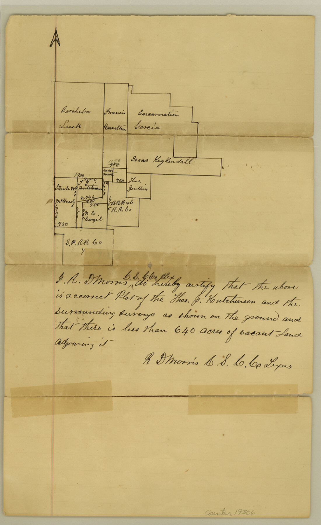
Cooke County Sketch File 37
[Sketch of surveys around Barsheba Lusk survey]
-
Map/Doc
19306
-
Collection
General Map Collection
-
Object Dates
1881/5/11 (File Date)
-
People and Organizations
R.D. Morris (Surveyor/Engineer)
Rhoads Fisher (GLO Clerk)
-
Counties
Cooke
-
Subjects
Surveying Sketch File
-
Height x Width
13.1 x 8.0 inches
33.3 x 20.3 cm
-
Medium
paper, manuscript
Part of: General Map Collection
Knox County Working Sketch 20

Print $20.00
- Digital $50.00
Knox County Working Sketch 20
2012
Size 40.2 x 36.9 inches
Map/Doc 93389
San Saba County Boundary File 77a

Print $51.00
- Digital $50.00
San Saba County Boundary File 77a
Size 17.3 x 10.8 inches
Map/Doc 58591
Pecos County Sketch File 1A

Print $20.00
- Digital $50.00
Pecos County Sketch File 1A
1919
Size 34.3 x 23.7 inches
Map/Doc 12155
Rio Grande Rectification Project, El Paso and Juarez Valley

Print $20.00
- Digital $50.00
Rio Grande Rectification Project, El Paso and Juarez Valley
1935
Size 10.7 x 29.4 inches
Map/Doc 60867
Ector County Working Sketch 10

Print $20.00
- Digital $50.00
Ector County Working Sketch 10
1953
Size 25.4 x 39.0 inches
Map/Doc 68853
Fannin County Sketch File 6

Print $20.00
- Digital $50.00
Fannin County Sketch File 6
1857
Size 17.0 x 14.5 inches
Map/Doc 11469
Johnson County Working Sketch 34

Print $20.00
- Digital $50.00
Johnson County Working Sketch 34
2008
Size 20.0 x 21.2 inches
Map/Doc 88890
Williamson County Sketch File 4

Print $26.00
- Digital $50.00
Williamson County Sketch File 4
1849
Size 15.9 x 10.4 inches
Map/Doc 40304
Kerr County Rolled Sketch 27

Print $20.00
- Digital $50.00
Kerr County Rolled Sketch 27
1983
Size 33.1 x 33.5 inches
Map/Doc 6506
Flight Mission No. DQN-1K, Frame 114, Calhoun County

Print $20.00
- Digital $50.00
Flight Mission No. DQN-1K, Frame 114, Calhoun County
1953
Size 18.5 x 22.3 inches
Map/Doc 84180
Gray County Sketch File 6

Print $20.00
- Digital $50.00
Gray County Sketch File 6
1882
Size 26.3 x 21.4 inches
Map/Doc 11575
Medina County Working Sketch 17

Print $20.00
- Digital $50.00
Medina County Working Sketch 17
1979
Size 26.8 x 34.5 inches
Map/Doc 70932
You may also like
Reeves County Working Sketch 6

Print $20.00
- Digital $50.00
Reeves County Working Sketch 6
1943
Size 14.1 x 18.4 inches
Map/Doc 63449
Panola County Working Sketch 23

Print $20.00
- Digital $50.00
Panola County Working Sketch 23
1951
Map/Doc 71432
Eastland County Working Sketch 3

Print $20.00
- Digital $50.00
Eastland County Working Sketch 3
1917
Size 16.5 x 20.2 inches
Map/Doc 68784
Flight Mission No. DIX-3P, Frame 169, Aransas County

Print $20.00
- Digital $50.00
Flight Mission No. DIX-3P, Frame 169, Aransas County
1956
Size 17.8 x 18.3 inches
Map/Doc 83775
Chambers County Sketch File 34

Print $10.00
- Digital $50.00
Chambers County Sketch File 34
1951
Size 14.3 x 8.8 inches
Map/Doc 17620
Upton County Working Sketch 34

Print $40.00
- Digital $50.00
Upton County Working Sketch 34
1956
Size 29.6 x 49.1 inches
Map/Doc 69530
Survey Gulf to Beaumont and Orange, Texas

Print $20.00
- Digital $50.00
Survey Gulf to Beaumont and Orange, Texas
1929
Size 29.3 x 41.7 inches
Map/Doc 3089
Wilbarger County Working Sketch 13

Print $20.00
- Digital $50.00
Wilbarger County Working Sketch 13
1954
Size 25.9 x 24.0 inches
Map/Doc 72551
Texas, San Antonio Bay, Guadalupe Bay

Print $40.00
- Digital $50.00
Texas, San Antonio Bay, Guadalupe Bay
1934
Size 28.8 x 48.4 inches
Map/Doc 69999
Galveston County Sketch File 71

Print $59.00
- Digital $50.00
Galveston County Sketch File 71
1994
Size 11.0 x 17.0 inches
Map/Doc 23941
Real County Working Sketch 62

Print $20.00
- Digital $50.00
Real County Working Sketch 62
1966
Size 26.4 x 23.2 inches
Map/Doc 71954
Flight Mission No. CRC-4R, Frame 104, Chambers County

Print $20.00
- Digital $50.00
Flight Mission No. CRC-4R, Frame 104, Chambers County
1956
Size 18.6 x 22.4 inches
Map/Doc 84901