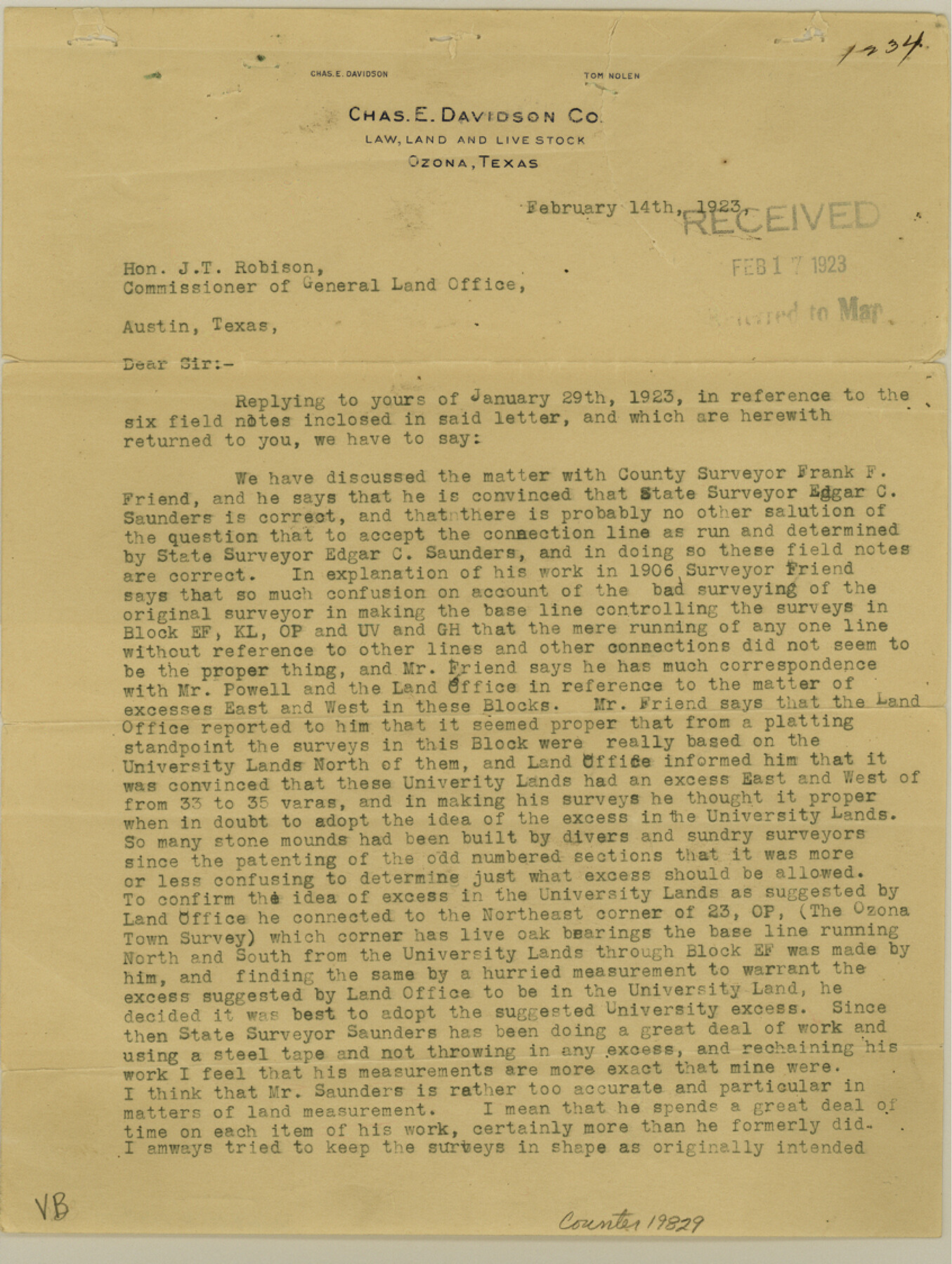
Crockett County Sketch File 55
[Letter regarding field notes]
-
Map/Doc
19829
-
Collection
General Map Collection
-
Object Dates
1923/2/14 (Creation Date)
1923/2/17 (File Date)
1906 (Survey Date)
-
People and Organizations
Charles E. Davidson and Company (Surveyor/Engineer)
Frank F. Friend (Surveyor/Engineer)
Edgar C. Saunders (Surveyor/Engineer)
-
Counties
Crockett
-
Subjects
Surveying Sketch File
-
Height x Width
11.2 x 8.5 inches
28.4 x 21.6 cm
-
Medium
paper, print
Related maps
Crockett County Sketch File 56

Print $20.00
- Digital $50.00
Crockett County Sketch File 56
Size 19.6 x 19.0 inches
Map/Doc 11224
Part of: General Map Collection
Sketch of a road from Fort Croghan to Phantom Hill, Texas

Print $20.00
- Digital $50.00
Sketch of a road from Fort Croghan to Phantom Hill, Texas
1852
Size 34.7 x 12.2 inches
Map/Doc 2007
Aransas County Working Sketch 2

Print $3.00
- Digital $50.00
Aransas County Working Sketch 2
1926
Size 16.3 x 9.7 inches
Map/Doc 67169
Wood County Boundary File 97

Print $2.00
- Digital $50.00
Wood County Boundary File 97
Size 9.4 x 4.5 inches
Map/Doc 60195
Dickens County Working Sketch 11

Print $40.00
- Digital $50.00
Dickens County Working Sketch 11
1969
Size 52.6 x 37.8 inches
Map/Doc 68659
Railroad Track Map, H&TCRRCo., Falls County, Texas

Print $4.00
- Digital $50.00
Railroad Track Map, H&TCRRCo., Falls County, Texas
1918
Size 11.8 x 18.6 inches
Map/Doc 62844
Kimble County Sketch File C

Print $4.00
- Digital $50.00
Kimble County Sketch File C
Size 14.9 x 7.5 inches
Map/Doc 28965
Flight Mission No. DIX-5P, Frame 151, Aransas County

Print $20.00
- Digital $50.00
Flight Mission No. DIX-5P, Frame 151, Aransas County
1956
Size 17.8 x 18.2 inches
Map/Doc 83813
Leon County Sketch File 21

Print $20.00
- Digital $50.00
Leon County Sketch File 21
1931
Size 18.2 x 22.8 inches
Map/Doc 11991
Pecos County Sketch File 85

Print $19.00
- Digital $50.00
Pecos County Sketch File 85
1948
Size 14.6 x 9.2 inches
Map/Doc 33955
Hutchinson County Rolled Sketch 43

Print $40.00
- Digital $50.00
Hutchinson County Rolled Sketch 43
1992
Size 40.5 x 49.4 inches
Map/Doc 6312
Cameron County Working Sketch Graphic Index

Print $20.00
- Digital $50.00
Cameron County Working Sketch Graphic Index
1976
Size 32.0 x 39.4 inches
Map/Doc 76486
Harris County Rolled Sketch 86

Print $20.00
- Digital $50.00
Harris County Rolled Sketch 86
1933
Size 33.0 x 32.2 inches
Map/Doc 73576
You may also like
Brazoria County Working Sketch 39

Print $40.00
- Digital $50.00
Brazoria County Working Sketch 39
1981
Size 74.6 x 44.1 inches
Map/Doc 67524
Runnels County Boundary File 2

Print $36.00
- Digital $50.00
Runnels County Boundary File 2
Size 14.4 x 8.8 inches
Map/Doc 58517
Johnson's New Map of the State of Texas

Print $20.00
- Digital $50.00
Johnson's New Map of the State of Texas
1859
Size 18.6 x 26.8 inches
Map/Doc 89254
Brewster County Sketch File N-18

Print $14.00
- Digital $50.00
Brewster County Sketch File N-18
1942
Size 14.2 x 8.9 inches
Map/Doc 15690
Colorado County Sketch File 29

Print $6.00
- Digital $50.00
Colorado County Sketch File 29
1842
Size 11.2 x 9.0 inches
Map/Doc 18974
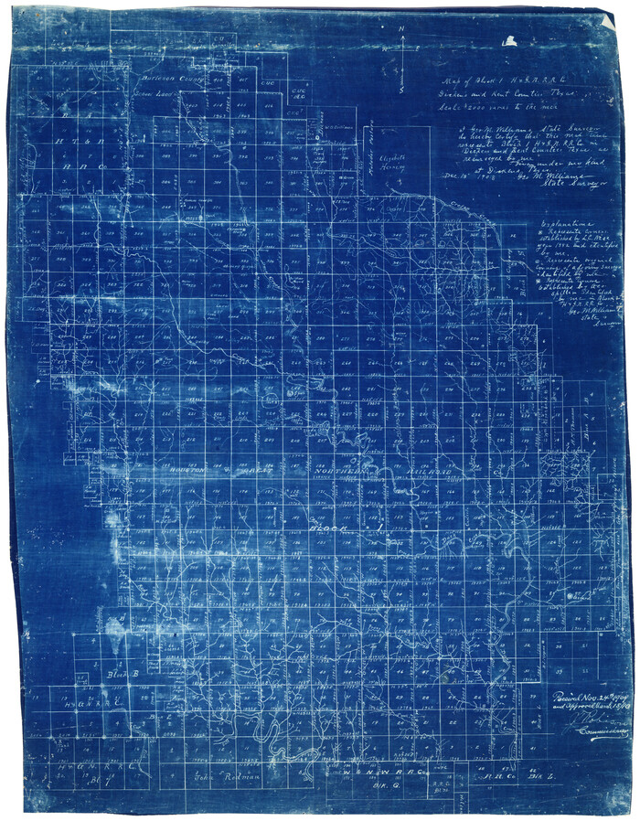
Map of Block 1, H. & G. N. R. R. Co., Dickens and Kent Counties Texas
Print $20.00
- Digital $50.00
Map of Block 1, H. & G. N. R. R. Co., Dickens and Kent Counties Texas
1908
Size 32.0 x 24.2 inches
Map/Doc 10780
Burleson County Working Sketch 1

Print $20.00
- Digital $50.00
Burleson County Working Sketch 1
1928
Size 23.4 x 17.4 inches
Map/Doc 67720
Flight Mission No. DIX-10P, Frame 63, Aransas County

Print $20.00
- Digital $50.00
Flight Mission No. DIX-10P, Frame 63, Aransas County
1956
Size 18.7 x 22.3 inches
Map/Doc 83924
Hood County Sketch File 3

Print $4.00
- Digital $50.00
Hood County Sketch File 3
1877
Size 12.7 x 8.1 inches
Map/Doc 26573
Howard McCauley Irrigated Farm North Half Section 2, Block D4

Print $20.00
- Digital $50.00
Howard McCauley Irrigated Farm North Half Section 2, Block D4
1946
Size 32.0 x 19.4 inches
Map/Doc 92342
Rusk County Sketch File 33

Print $10.00
Rusk County Sketch File 33
1949
Size 11.5 x 8.8 inches
Map/Doc 35568
Flight Mission No. CGI-3N, Frame 102, Cameron County

Print $20.00
- Digital $50.00
Flight Mission No. CGI-3N, Frame 102, Cameron County
1954
Size 18.6 x 22.2 inches
Map/Doc 84582