Floyd County Sketch File 13
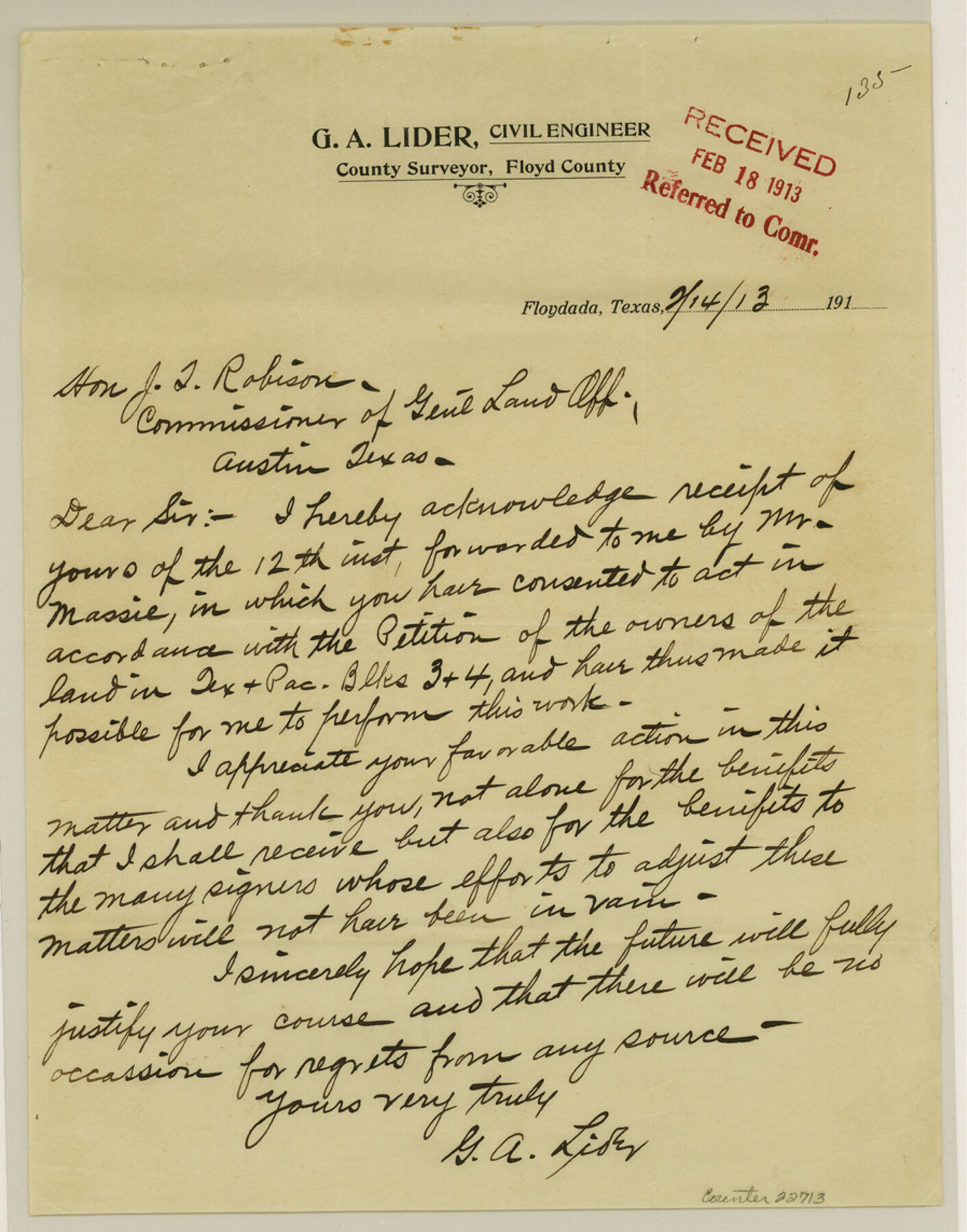
[Correspondence with G. A. Lider, County Surveyor]
-
Map/Doc
22713
-
Collection
General Map Collection
-
Object Dates
1913/4/22 (Creation Date)
-
People and Organizations
George A. Lider (Surveyor/Engineer)
W.D. Twichell (Surveyor/Engineer)
E. von Rosenberg (GLO Commissioner)
-
Counties
Floyd Briscoe Hall Motley
-
Subjects
Surveying Sketch File
-
Height x Width
11.4 x 9.0 inches
29.0 x 22.9 cm
-
Medium
multi-page, multi-format
-
Features
Pease River
Quitaque River
Quintanna
North Pease River
Tom Ball Creek
Pole Canon
Related maps
Briscoe County Rolled Sketch 14

Print $40.00
- Digital $50.00
Briscoe County Rolled Sketch 14
1913
Size 36.0 x 48.9 inches
Map/Doc 8529
Briscoe County Rolled Sketch 14A

Print $40.00
- Digital $50.00
Briscoe County Rolled Sketch 14A
1913
Size 34.6 x 48.1 inches
Map/Doc 8530
Part of: General Map Collection
Presidio County Working Sketch 62

Print $3.00
- Digital $50.00
Presidio County Working Sketch 62
1958
Size 12.6 x 9.5 inches
Map/Doc 71739
Menard County Sketch File 13

Print $4.00
- Digital $50.00
Menard County Sketch File 13
1892
Size 12.8 x 8.2 inches
Map/Doc 31506
Ochiltree County

Print $20.00
- Digital $50.00
Ochiltree County
1958
Size 44.4 x 35.5 inches
Map/Doc 95603
Culberson County Rolled Sketch 39

Print $20.00
- Digital $50.00
Culberson County Rolled Sketch 39
Size 20.5 x 28.7 inches
Map/Doc 78465
McMullen County Rolled Sketch 18

Print $20.00
- Digital $50.00
McMullen County Rolled Sketch 18
Size 18.8 x 27.5 inches
Map/Doc 6734

Recharge zone of the Edwards Aquifer hydrologically associated with Barton Springs in the Austin Area, Texas

Print $20.00
- Digital $50.00
Recharge zone of the Edwards Aquifer hydrologically associated with Barton Springs in the Austin Area, Texas
1986
Size 41.5 x 29.3 inches
Map/Doc 60400
Sterling County Sketch File 25

Print $4.00
- Digital $50.00
Sterling County Sketch File 25
1892
Size 11.1 x 8.9 inches
Map/Doc 37192

Mitchell County Rolled Sketch 3

Print $40.00
- Digital $50.00
Mitchell County Rolled Sketch 3
1940
Size 39.6 x 49.0 inches
Map/Doc 9524
El Paso County Rolled Sketch Z57

Print $20.00
- Digital $50.00
El Paso County Rolled Sketch Z57
1915
Size 36.5 x 47.2 inches
Map/Doc 8871
Map of Runnels County

Print $20.00
- Digital $50.00
Map of Runnels County
1887
Size 24.7 x 19.9 inches
Map/Doc 4000
You may also like
Flight Mission No. DCL-7C, Frame 21, Kenedy County

Print $20.00
- Digital $50.00
Flight Mission No. DCL-7C, Frame 21, Kenedy County
1943
Size 15.3 x 15.2 inches
Map/Doc 86013
Brazos River Conservation and Reclamation District Official Boundary Line Survey, Parmer County

Print $20.00
- Digital $50.00
Brazos River Conservation and Reclamation District Official Boundary Line Survey, Parmer County
Size 24.7 x 16.8 inches
Map/Doc 91656
Newton County Rolled Sketch 27

Print $20.00
- Digital $50.00
Newton County Rolled Sketch 27
1961
Size 36.0 x 27.3 inches
Map/Doc 6856
Louisiana and Texas Intracoastal Waterway

Print $20.00
- Digital $50.00
Louisiana and Texas Intracoastal Waterway
1929
Size 13.8 x 19.7 inches
Map/Doc 83340
Hale County Working Sketch 2

Print $20.00
- Digital $50.00
Hale County Working Sketch 2
1916
Size 13.5 x 13.1 inches
Map/Doc 63322
Sabine River, Gladewater Sheet

Print $20.00
- Digital $50.00
Sabine River, Gladewater Sheet
1933
Size 38.5 x 30.9 inches
Map/Doc 65138

Jeff Davis County Sketch File 18

Print $71.00
- Digital $50.00
Jeff Davis County Sketch File 18
Size 9.7 x 12.9 inches
Map/Doc 27951
Mason County Sketch File 18

Print $4.00
- Digital $50.00
Mason County Sketch File 18
1901
Size 14.0 x 8.6 inches
Map/Doc 30709
Foard County Sketch File 18

Print $6.00
- Digital $50.00
Foard County Sketch File 18
1888
Size 13.0 x 8.5 inches
Map/Doc 22834
Hardin County Rolled Sketch 5

Print $20.00
- Digital $50.00
Hardin County Rolled Sketch 5
1937
Size 21.5 x 18.8 inches
Map/Doc 6078
Panola County Working Sketch 15

Print $40.00
- Digital $50.00
Panola County Working Sketch 15
1945
Map/Doc 71424