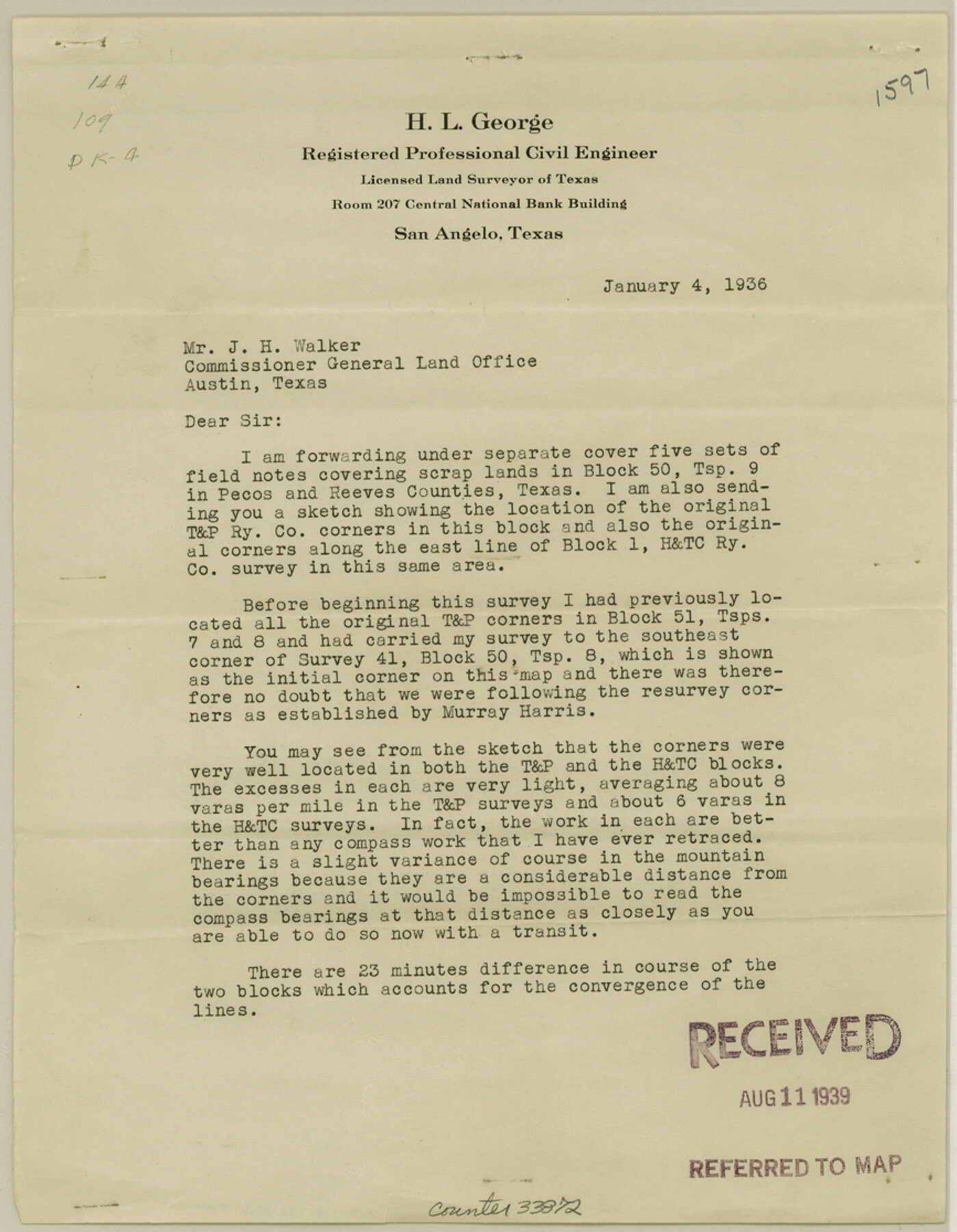
Pecos County Sketch File 71
[Explanation of T. & P. RR. Co. Block 50, Township 9]
-
Map/Doc
33872
-
Collection
General Map Collection
-
Object Dates
3/11/1936 (Creation Date)
8/11/1939 (File Date)
1/4/1936 (Correspondence Date)
3/11/1936 (Correspondence Date)
-
People and Organizations
H.L. George (Surveyor/Engineer)
Murray Harris (Surveyor/Engineer)
-
Counties
Pecos Reeves
-
Subjects
Surveying Sketch File
-
Height x Width
11.2 x 8.7 inches
28.5 x 22.1 cm
-
Medium
paper, typed
Part of: General Map Collection
Anderson County Sketch File 29

Print $4.00
- Digital $50.00
Anderson County Sketch File 29
1873
Size 10.4 x 8.2 inches
Map/Doc 12814
Freestone County Working Sketch 31

Print $20.00
- Digital $50.00
Freestone County Working Sketch 31
1995
Size 42.8 x 33.9 inches
Map/Doc 78205
Reagan County Rolled Sketch 26

Print $20.00
- Digital $50.00
Reagan County Rolled Sketch 26
1951
Size 32.7 x 42.7 inches
Map/Doc 9820
Plan of the City of Galveston, Texas

Print $20.00
- Digital $50.00
Plan of the City of Galveston, Texas
1845
Size 18.4 x 27.8 inches
Map/Doc 62970
Kimble County Rolled Sketch 30

Print $20.00
- Digital $50.00
Kimble County Rolled Sketch 30
Size 26.0 x 20.4 inches
Map/Doc 6520
Flight Mission No. BRA-16M, Frame 97, Jefferson County

Print $20.00
- Digital $50.00
Flight Mission No. BRA-16M, Frame 97, Jefferson County
1953
Size 18.5 x 22.4 inches
Map/Doc 85709
Liberty County Sketch File 51

Print $4.00
- Digital $50.00
Liberty County Sketch File 51
Size 7.9 x 13.8 inches
Map/Doc 30017
Edwards County Sketch File 43

Print $20.00
- Digital $50.00
Edwards County Sketch File 43
1947
Size 17.4 x 18.2 inches
Map/Doc 11441
Hemphill County Sketch file 6b

Print $20.00
- Digital $50.00
Hemphill County Sketch file 6b
1903
Size 13.7 x 24.3 inches
Map/Doc 11752
Bell County Sketch File 5

Print $4.00
- Digital $50.00
Bell County Sketch File 5
1849
Size 12.9 x 8.5 inches
Map/Doc 14371
Map of Grimes County
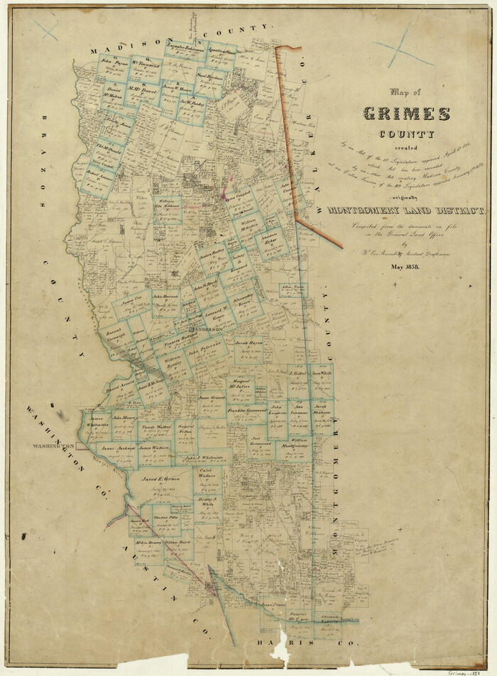
Print $20.00
- Digital $50.00
Map of Grimes County
1858
Size 29.1 x 21.4 inches
Map/Doc 3605
Marion County

Print $20.00
- Digital $50.00
Marion County
1943
Size 24.3 x 41.2 inches
Map/Doc 77365
You may also like
Hardin County Working Sketch 4

Print $3.00
- Digital $50.00
Hardin County Working Sketch 4
1906
Size 11.0 x 16.8 inches
Map/Doc 63402
Presidio County Working Sketch 113

Print $40.00
- Digital $50.00
Presidio County Working Sketch 113
1981
Size 48.9 x 37.1 inches
Map/Doc 71790
Shackelford County Boundary File 6

Print $6.00
- Digital $50.00
Shackelford County Boundary File 6
Size 11.4 x 8.8 inches
Map/Doc 58668
Lipscomb County Boundary File 4

Print $14.00
- Digital $50.00
Lipscomb County Boundary File 4
Size 11.1 x 8.6 inches
Map/Doc 56320
Gregg County Rolled Sketch 28

Print $77.00
- Digital $50.00
Gregg County Rolled Sketch 28
1934
Size 10.1 x 15.2 inches
Map/Doc 45639
Edwards County Working Sketch 122

Print $20.00
- Digital $50.00
Edwards County Working Sketch 122
1976
Size 25.8 x 33.9 inches
Map/Doc 68998
Dickens County Boundary File 4

Print $52.00
- Digital $50.00
Dickens County Boundary File 4
Size 14.2 x 8.7 inches
Map/Doc 52546
Martin County Boundary File 2a

Print $6.00
- Digital $50.00
Martin County Boundary File 2a
Size 14.1 x 8.8 inches
Map/Doc 56776
Intracoastal Waterway in Texas - Corpus Christi to Point Isabel including Arroyo Colorado to Mo. Pac. R.R. Bridge Near Harlingen

Print $20.00
- Digital $50.00
Intracoastal Waterway in Texas - Corpus Christi to Point Isabel including Arroyo Colorado to Mo. Pac. R.R. Bridge Near Harlingen
1933
Size 27.8 x 40.9 inches
Map/Doc 61864
Nueces County Rolled Sketch 133

Print $26.00
Nueces County Rolled Sketch 133
2001
Size 24.8 x 36.8 inches
Map/Doc 7168
[Surveying Sketch of L. Smith, Sidney Shepherd, Kenneth Hyman, et al in Montgomery County]
![625, [Surveying Sketch of L. Smith, Sidney Shepherd, Kenneth Hyman, et al in Montgomery County], Maddox Collection](https://historictexasmaps.com/wmedia_w700/maps/00625.tif.jpg)
Print $2.00
- Digital $50.00
[Surveying Sketch of L. Smith, Sidney Shepherd, Kenneth Hyman, et al in Montgomery County]
Size 7.3 x 10.6 inches
Map/Doc 625
Harris County NRC Article 33.136 Sketch 12

Print $30.00
- Digital $50.00
Harris County NRC Article 33.136 Sketch 12
2007
Size 24.0 x 17.5 inches
Map/Doc 94627