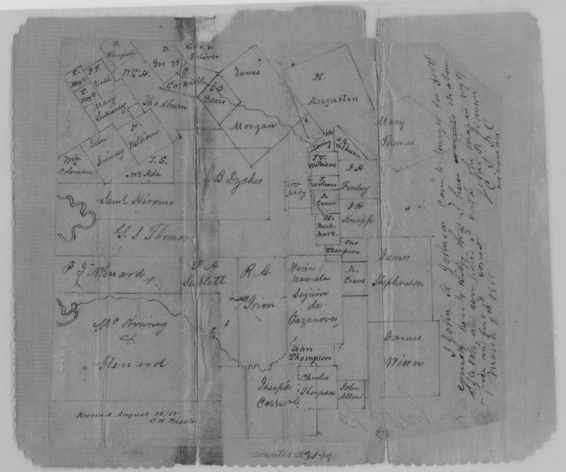
Polk County Sketch File 11a
[Sketch in southeast corner of county]
-
Map/Doc
34144
-
Collection
General Map Collection
-
Object Dates
8/30/1858 (File Date)
3/9/1858 (Survey Date)
-
People and Organizations
John R. Johnson (Surveyor/Engineer)
-
Counties
Polk Hardin Liberty
-
Subjects
Surveying Sketch File
-
Height x Width
8.1 x 9.7 inches
20.6 x 24.6 cm
-
Medium
paper, manuscript
Part of: General Map Collection
Gaines County Sketch File 13

Print $40.00
- Digital $50.00
Gaines County Sketch File 13
1954
Size 8.9 x 20.4 inches
Map/Doc 23200
Archer County Sketch File 25

Print $40.00
- Digital $50.00
Archer County Sketch File 25
Size 22.3 x 46.6 inches
Map/Doc 10348
Hansford County Boundary File 3

Print $10.00
- Digital $50.00
Hansford County Boundary File 3
Size 13.6 x 8.7 inches
Map/Doc 54270
Frio County Working Sketch 4

Print $20.00
- Digital $50.00
Frio County Working Sketch 4
1924
Size 26.4 x 27.2 inches
Map/Doc 69278
Upton County Sketch File 41

Print $20.00
- Digital $50.00
Upton County Sketch File 41
1964
Size 33.8 x 26.0 inches
Map/Doc 12525
Flight Mission No. CGI-3N, Frame 122, Cameron County

Print $20.00
- Digital $50.00
Flight Mission No. CGI-3N, Frame 122, Cameron County
1954
Size 18.6 x 22.2 inches
Map/Doc 84595
Kinney County

Print $40.00
- Digital $50.00
Kinney County
1909
Size 48.4 x 42.7 inches
Map/Doc 16868
Yoakum County Sketch File 16

Print $20.00
- Digital $50.00
Yoakum County Sketch File 16
1939
Size 15.0 x 19.4 inches
Map/Doc 12709


Atascosa County

Print $20.00
- Digital $50.00
Atascosa County
1948
Size 47.2 x 46.3 inches
Map/Doc 95421
Kimble County Working Sketch 63

Print $20.00
- Digital $50.00
Kimble County Working Sketch 63
1964
Size 31.2 x 34.2 inches
Map/Doc 70131
You may also like
Blanco County Sketch File 34

Print $4.00
- Digital $50.00
Blanco County Sketch File 34
1879
Size 12.7 x 8.2 inches
Map/Doc 14637
[Texas & Pacific Railway through Callahan County]
![64237, [Texas & Pacific Railway through Callahan County], General Map Collection](https://historictexasmaps.com/wmedia_w700/maps/64237.tif.jpg)
Print $20.00
- Digital $50.00
[Texas & Pacific Railway through Callahan County]
1918
Size 21.8 x 9.2 inches
Map/Doc 64237

Floyd County Sketch File 19

Print $6.00
- Digital $50.00
Floyd County Sketch File 19
1913
Size 9.8 x 8.4 inches
Map/Doc 22769
Liberty County Sketch File 24

Print $6.00
- Digital $50.00
Liberty County Sketch File 24
Size 10.2 x 7.9 inches
Map/Doc 29936
Stonewall County Sketch File 16

Print $16.00
- Digital $50.00
Stonewall County Sketch File 16
1902
Size 12.8 x 8.3 inches
Map/Doc 37266
Mason County Working Sketch 8

Print $20.00
- Digital $50.00
Mason County Working Sketch 8
1946
Size 22.9 x 32.3 inches
Map/Doc 70844
Carson County Boundary File 9

Print $74.00
- Digital $50.00
Carson County Boundary File 9
Size 9.0 x 8.9 inches
Map/Doc 51175
Williamson County Sketch File 19

Print $24.00
- Digital $50.00
Williamson County Sketch File 19
Size 12.8 x 8.0 inches
Map/Doc 40345
Baylor County Sketch File 8

Print $44.00
- Digital $50.00
Baylor County Sketch File 8
1887
Size 13.0 x 8.6 inches
Map/Doc 14137
Flight Mission No. DQO-3K, Frame 78, Galveston County

Print $20.00
- Digital $50.00
Flight Mission No. DQO-3K, Frame 78, Galveston County
1952
Size 18.8 x 22.6 inches
Map/Doc 85083
Fannin County Working Sketch 7

Print $20.00
- Digital $50.00
Fannin County Working Sketch 7
1952
Size 25.4 x 28.5 inches
Map/Doc 69161