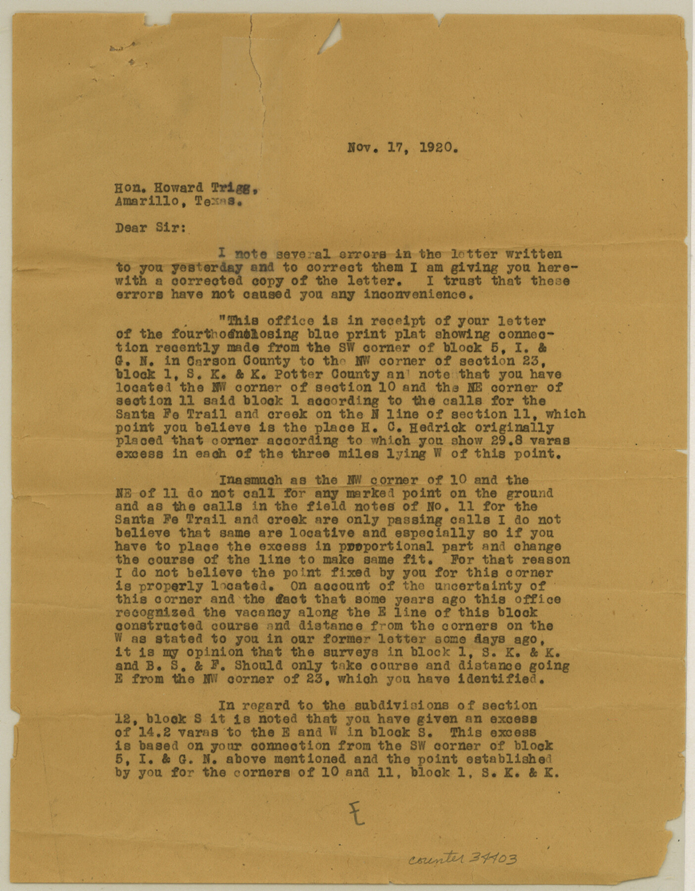
Potter County Sketch File 17
[Correspondence with Howard T. Trigg]
-
Map/Doc
34403
-
Collection
General Map Collection
-
Object Dates
10/25/1920 (Creation Date)
11/17/1920 (Correspondence Date)
10/25/1920 (Correspondence Date)
11/4/1920 (Correspondence Date)
1887 (Survey Date)
10/11/1920 (Correspondence Date)
6/29/1875 (Survey Date)
1900 (Survey Date)
-
People and Organizations
Howard T. Trigg (Surveyor/Engineer)
H.C. Hedrick (Surveyor/Engineer)
Omohondro (Surveyor/Engineer)
James Gray (Surveyor/Engineer)
W.D. Twichell (Surveyor/Engineer)
-
Counties
Potter Carson
-
Subjects
Surveying Sketch File
-
Height x Width
11.2 x 8.7 inches
28.4 x 22.1 cm
-
Medium
paper, print
-
Features
Santa Fe Trail
Part of: General Map Collection
Bastrop County Working Sketch 2

Print $20.00
- Digital $50.00
Bastrop County Working Sketch 2
1913
Size 14.0 x 13.6 inches
Map/Doc 67302
Kinney County Rolled Sketch 14

Print $20.00
- Digital $50.00
Kinney County Rolled Sketch 14
1956
Size 19.5 x 25.8 inches
Map/Doc 6543
Armstrong County Sketch File A

Print $46.00
- Digital $50.00
Armstrong County Sketch File A
1902
Size 8.6 x 20.0 inches
Map/Doc 13665
El Paso County Boundary File 25

Print $10.00
- Digital $50.00
El Paso County Boundary File 25
Size 13.0 x 8.9 inches
Map/Doc 53226
Pecos County Rolled Sketch 147

Print $449.00
- Digital $50.00
Pecos County Rolled Sketch 147
1957
Size 10.1 x 15.4 inches
Map/Doc 48414
Jasper County

Print $40.00
- Digital $50.00
Jasper County
1946
Size 49.8 x 43.9 inches
Map/Doc 95542
Young County Working Sketch 2

Print $20.00
- Digital $50.00
Young County Working Sketch 2
1918
Size 28.1 x 33.7 inches
Map/Doc 62025
Jim Hogg County Rolled Sketch 6

Print $40.00
- Digital $50.00
Jim Hogg County Rolled Sketch 6
1943
Size 51.9 x 38.4 inches
Map/Doc 9322
Pecos County Working Sketch 66

Print $20.00
- Digital $50.00
Pecos County Working Sketch 66
1955
Size 25.8 x 21.2 inches
Map/Doc 71538
Flight Mission No. BQR-9K, Frame 45, Brazoria County

Print $20.00
- Digital $50.00
Flight Mission No. BQR-9K, Frame 45, Brazoria County
1952
Size 18.7 x 22.3 inches
Map/Doc 84049
Intracoastal Waterway in Texas - Corpus Christi to Point Isabel including Arroyo Colorado to Mo. Pac. R.R. Bridge Near Harlingen

Print $20.00
- Digital $50.00
Intracoastal Waterway in Texas - Corpus Christi to Point Isabel including Arroyo Colorado to Mo. Pac. R.R. Bridge Near Harlingen
1933
Size 27.7 x 40.9 inches
Map/Doc 61859
Glasscock County

Print $20.00
- Digital $50.00
Glasscock County
1933
Size 47.0 x 39.2 inches
Map/Doc 1839
You may also like
Brazoria County Working Sketch 17

Print $20.00
- Digital $50.00
Brazoria County Working Sketch 17
1948
Size 17.0 x 19.0 inches
Map/Doc 67502
Texas City Channel, Texas, Channel and Turning Basin Dredging - Sheet 6

Print $20.00
- Digital $50.00
Texas City Channel, Texas, Channel and Turning Basin Dredging - Sheet 6
1958
Size 28.6 x 40.6 inches
Map/Doc 61836
Falls County Sketch File 16a

Print $20.00
- Digital $50.00
Falls County Sketch File 16a
1871
Size 30.6 x 21.0 inches
Map/Doc 11466
Reeves County Working Sketch 6

Print $20.00
- Digital $50.00
Reeves County Working Sketch 6
1943
Size 14.1 x 18.4 inches
Map/Doc 63449
Hudspeth County Rolled Sketch 66

Print $20.00
- Digital $50.00
Hudspeth County Rolled Sketch 66
1973
Size 12.1 x 18.7 inches
Map/Doc 6261
Hood County Sketch File 22

Print $6.00
- Digital $50.00
Hood County Sketch File 22
Size 15.7 x 9.3 inches
Map/Doc 26615
Chambers County Sketch File 34

Print $10.00
- Digital $50.00
Chambers County Sketch File 34
1951
Size 14.3 x 8.8 inches
Map/Doc 17620
Presidio County Rolled Sketch 85

Print $20.00
- Digital $50.00
Presidio County Rolled Sketch 85
1930
Size 28.3 x 27.3 inches
Map/Doc 7371
Wood County Boundary File 5

Print $20.00
- Digital $50.00
Wood County Boundary File 5
Size 10.8 x 8.1 inches
Map/Doc 60170
Uvalde County Working Sketch 41

Print $20.00
- Digital $50.00
Uvalde County Working Sketch 41
1975
Size 15.6 x 27.4 inches
Map/Doc 72111
Map of Schleicher Co.

Print $20.00
- Digital $50.00
Map of Schleicher Co.
1891
Size 24.4 x 32.5 inches
Map/Doc 63024
General Highway Map. Detail of Cities and Towns in Cherokee County, Texas [Jacksonville, Rusk, Alto, Wells, and vicinities of these cities]
![79407, General Highway Map. Detail of Cities and Towns in Cherokee County, Texas [Jacksonville, Rusk, Alto, Wells, and vicinities of these cities], Texas State Library and Archives](https://historictexasmaps.com/wmedia_w700/maps/79407.tif.jpg)
Print $20.00
General Highway Map. Detail of Cities and Towns in Cherokee County, Texas [Jacksonville, Rusk, Alto, Wells, and vicinities of these cities]
1961
Size 18.2 x 24.9 inches
Map/Doc 79407