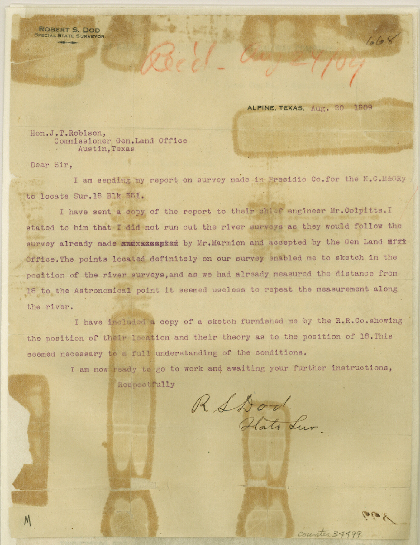
Presidio County Sketch File 37A
[Report on work from Astronomical Point to section 18, Block 351]
-
Map/Doc
34499
-
Collection
General Map Collection
-
Object Dates
8/24/1909 (File Date)
8/20/1909 (Correspondence Date)
-
People and Organizations
R.S. Dod (Surveyor/Engineer)
Marmion (Surveyor/Engineer)
Emory (Surveyor/Engineer)
S.A. Thompson (Surveyor/Engineer)
-
Counties
Presidio
-
Subjects
Surveying Sketch File
-
Height x Width
11.4 x 8.8 inches
29.0 x 22.4 cm
-
Medium
paper, print
-
Comments
See Presidio County Sketch File 37 (34491) for report, and Presidio County Rolled Sketch D (7408) for sketch.
-
Features
Presidio
Rio Grande
KCM&O
Alpine
Cigar Springs
Grande Cañon
Alamo
Alamita Creek
Big Chianti Mountain
San Jacinto Peak
El Alamo Spring
Daly Ranch
Chipadero Spring
Pointed Peak
Cienega Peak
Black Hills
Related maps
Presidio County Sketch File 37

Print $16.00
- Digital $50.00
Presidio County Sketch File 37
Size 14.3 x 8.7 inches
Map/Doc 34491
Presidio County Rolled Sketch D

Print $20.00
- Digital $50.00
Presidio County Rolled Sketch D
Size 13.7 x 22.4 inches
Map/Doc 7408
Part of: General Map Collection
Flight Mission No. BQR-12K, Frame 50, Brazoria County

Print $20.00
- Digital $50.00
Flight Mission No. BQR-12K, Frame 50, Brazoria County
1952
Size 18.7 x 22.4 inches
Map/Doc 84065
Map of a part of Laguna Madre showing subdivision for mineral development

Print $20.00
- Digital $50.00
Map of a part of Laguna Madre showing subdivision for mineral development
1948
Size 37.4 x 27.7 inches
Map/Doc 2914
Ochiltree County Sketch File 12

Print $24.00
- Digital $50.00
Ochiltree County Sketch File 12
1990
Size 11.2 x 8.5 inches
Map/Doc 33201
El Paso County Boundary File 14

Print $8.00
- Digital $50.00
El Paso County Boundary File 14
Size 13.0 x 8.6 inches
Map/Doc 53179
Flight Mission No. BRA-3M, Frame 199, Jefferson County

Print $20.00
- Digital $50.00
Flight Mission No. BRA-3M, Frame 199, Jefferson County
1953
Size 18.6 x 22.3 inches
Map/Doc 85414
Partie du Mexique

Print $20.00
- Digital $50.00
Partie du Mexique
1827
Size 20.4 x 27.8 inches
Map/Doc 94072
Galveston County Rolled Sketch WF

Print $20.00
- Digital $50.00
Galveston County Rolled Sketch WF
Size 25.2 x 34.1 inches
Map/Doc 5991
Hood County Sketch File 2

Print $4.00
- Digital $50.00
Hood County Sketch File 2
Size 9.7 x 8.2 inches
Map/Doc 26571
Smith County Sketch File 7

Print $4.00
- Digital $50.00
Smith County Sketch File 7
1848
Size 12.7 x 8.2 inches
Map/Doc 36759
Flight Mission No. DCL-5C, Frame 49, Kenedy County

Print $20.00
- Digital $50.00
Flight Mission No. DCL-5C, Frame 49, Kenedy County
1943
Size 18.5 x 22.3 inches
Map/Doc 85845
Kleberg County Rolled Sketch 10-13

Print $20.00
- Digital $50.00
Kleberg County Rolled Sketch 10-13
1952
Size 37.0 x 32.5 inches
Map/Doc 9391
Jasper County Working Sketch 21

Print $20.00
- Digital $50.00
Jasper County Working Sketch 21
1941
Size 13.1 x 21.4 inches
Map/Doc 66483
You may also like
Burnet County Rolled Sketch D

Print $20.00
- Digital $50.00
Burnet County Rolled Sketch D
1924
Size 47.3 x 40.8 inches
Map/Doc 8541
Brazos River Conservation and Reclamation District Official Boundary Line Survey

Print $20.00
- Digital $50.00
Brazos River Conservation and Reclamation District Official Boundary Line Survey
Size 37.3 x 24.7 inches
Map/Doc 90129
Jim Hogg County Working Sketch 5

Print $20.00
- Digital $50.00
Jim Hogg County Working Sketch 5
1941
Size 40.8 x 41.0 inches
Map/Doc 66591

El Paso County Rolled Sketch 49

Print $40.00
- Digital $50.00
El Paso County Rolled Sketch 49
Size 10.5 x 99.9 inches
Map/Doc 8875
Franklin County Working Sketch 1

Print $20.00
- Digital $50.00
Franklin County Working Sketch 1
1915
Size 20.4 x 11.8 inches
Map/Doc 69239
Colorado County Sketch File 34

Print $86.00
- Digital $50.00
Colorado County Sketch File 34
1996
Size 14.2 x 8.8 inches
Map/Doc 18992
Crockett County Rolled Sketch 80

Print $40.00
- Digital $50.00
Crockett County Rolled Sketch 80
1954
Size 24.8 x 55.5 inches
Map/Doc 8725
Right of Way and Track Map, International & Gt. Northern Ry. operated by the International & Gt. Northern Ry. Co. Gulf Division, Mineola Branch

Print $40.00
- Digital $50.00
Right of Way and Track Map, International & Gt. Northern Ry. operated by the International & Gt. Northern Ry. Co. Gulf Division, Mineola Branch
1917
Size 25.4 x 121.1 inches
Map/Doc 64702


Lavaca County Working Sketch 13

Print $20.00
- Digital $50.00
Lavaca County Working Sketch 13
1958
Size 23.5 x 29.1 inches
Map/Doc 70366