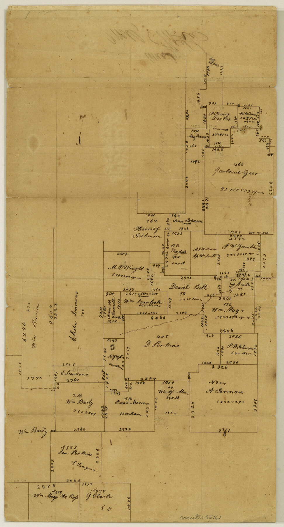
Red River County Sketch File 26
[Sketch of surveys in the northwest corner of the county]
-
Map/Doc
35161
-
Collection
General Map Collection
-
Counties
Red River
-
Subjects
Surveying Sketch File
-
Height x Width
14.7 x 7.9 inches
37.3 x 20.1 cm
-
Medium
paper, manuscript
Part of: General Map Collection
Knox County Boundary File 3

Print $54.00
- Digital $50.00
Knox County Boundary File 3
Size 8.9 x 7.7 inches
Map/Doc 65019
Galveston County Sketch File 47

Print $14.00
- Digital $50.00
Galveston County Sketch File 47
1976
Size 11.3 x 8.9 inches
Map/Doc 23454
Hardeman County Working Sketch 18

Print $20.00
- Digital $50.00
Hardeman County Working Sketch 18
2002
Size 33.5 x 36.5 inches
Map/Doc 76401
McMullen County Rolled Sketch 8

Print $20.00
- Digital $50.00
McMullen County Rolled Sketch 8
Size 26.0 x 26.3 inches
Map/Doc 6725
Crane County Sketch File 4

Print $6.00
- Digital $50.00
Crane County Sketch File 4
Size 13.6 x 10.9 inches
Map/Doc 19562
Upton County Sketch File 15

Print $20.00
- Digital $50.00
Upton County Sketch File 15
1927
Size 34.3 x 19.5 inches
Map/Doc 12513
Haskell County Sketch File 7

Print $22.00
- Digital $50.00
Haskell County Sketch File 7
Size 7.8 x 13.4 inches
Map/Doc 26128
Anderson County Sketch File 13

Print $10.00
- Digital $50.00
Anderson County Sketch File 13
1856
Size 8.1 x 8.3 inches
Map/Doc 12774
Intracoastal Waterway - Gibbstown to Port Arthur

Print $20.00
- Digital $50.00
Intracoastal Waterway - Gibbstown to Port Arthur
1960
Size 26.9 x 38.9 inches
Map/Doc 69831
Shelby County Sketch File 30

Print $4.00
- Digital $50.00
Shelby County Sketch File 30
1927
Size 14.3 x 8.8 inches
Map/Doc 36668
Terry County Rolled Sketch 4

Print $20.00
- Digital $50.00
Terry County Rolled Sketch 4
Size 38.7 x 36.8 inches
Map/Doc 9994
Flight Mission No. BRA-16M, Frame 148, Jefferson County

Print $20.00
- Digital $50.00
Flight Mission No. BRA-16M, Frame 148, Jefferson County
1953
Size 18.5 x 22.2 inches
Map/Doc 85754
You may also like
Kendall County Rolled Sketch 3

Print $9.00
- Digital $50.00
Kendall County Rolled Sketch 3
1858
Size 10.0 x 15.3 inches
Map/Doc 46424
Atascosa County Rolled Sketch 16

Print $20.00
- Digital $50.00
Atascosa County Rolled Sketch 16
1952
Size 22.7 x 38.3 inches
Map/Doc 5096
Map of Kyle, Lockhart & Southern Ry.

Print $40.00
- Digital $50.00
Map of Kyle, Lockhart & Southern Ry.
1882
Size 14.5 x 94.9 inches
Map/Doc 64285
Ride the Texas Mountain Trail [Recto]
![94164, Ride the Texas Mountain Trail [Recto], General Map Collection](https://historictexasmaps.com/wmedia_w700/maps/94164.tif.jpg)
Ride the Texas Mountain Trail [Recto]
1968
Size 18.4 x 24.3 inches
Map/Doc 94164
Duval County Working Sketch 38

Print $20.00
- Digital $50.00
Duval County Working Sketch 38
1960
Size 18.3 x 22.8 inches
Map/Doc 68762
Zavala County Sketch File 49

Print $10.00
- Digital $50.00
Zavala County Sketch File 49
1955
Size 14.5 x 9.1 inches
Map/Doc 41441
Pecos County Working Sketch 1

Print $20.00
- Digital $50.00
Pecos County Working Sketch 1
Size 16.0 x 13.0 inches
Map/Doc 71471
Culberson County Sketch File 28

Print $4.00
- Digital $50.00
Culberson County Sketch File 28
1949
Size 14.5 x 9.0 inches
Map/Doc 20280
Hudspeth County Rolled Sketch 65

Print $40.00
- Digital $50.00
Hudspeth County Rolled Sketch 65
1988
Size 70.5 x 37.7 inches
Map/Doc 9229
Kent County Sketch File 12

Print $20.00
- Digital $50.00
Kent County Sketch File 12
1911
Size 26.8 x 23.6 inches
Map/Doc 11916
Railroad Track Map, H&TCRRCo., Falls County, Texas

Print $4.00
- Digital $50.00
Railroad Track Map, H&TCRRCo., Falls County, Texas
1918
Size 11.4 x 18.7 inches
Map/Doc 62851
University Lands Blocks 29-33, Crockett County, Texas

Print $20.00
- Digital $50.00
University Lands Blocks 29-33, Crockett County, Texas
1936
Size 29.8 x 42.7 inches
Map/Doc 2443