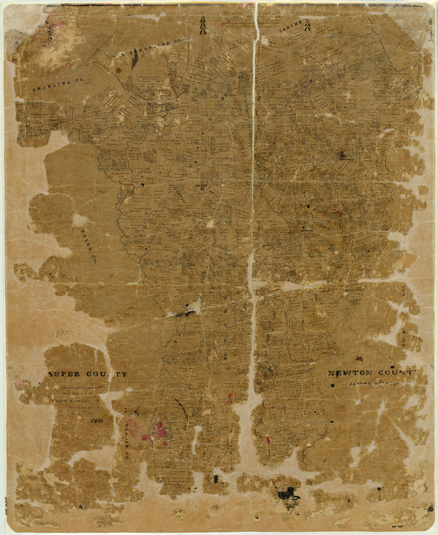
Jasper County
-
Map/Doc
3717
-
Collection
General Map Collection
-
Object Dates
1882 (Creation Date)
-
People and Organizations
George J. Thielepape (Draftsman)
-
Counties
Jasper Newton
-
Subjects
County
-
Height x Width
34.8 x 28.6 inches
88.4 x 72.6 cm
-
Features
Marcus Creek
Thickety Creek
Prairie Creek
Sandy Creek
Jasper
Walnut Run
Caney Creek
Richman Creek
Brody Creek
Spring Creek
Pine Creek
Robinson Branch [of Neches River]
White Oak Creek
Walnut Creek
Newton
Huckelberry Creek
Big Quicksand Creek
West Branch of Big Quicksand Creek
East Branch of Big Quicksand Creek
Wright Creek
Boggy Creek
Trout Creek
Big Creek
Neches River
Sabine River
Hog Creek
South Branch of Thickety Creek
Richland Creek
Martin Mill Creek
Aurelia Creek
Indian Creek
Ayish Bayou
Bear Creek
Angelina River
Tiger Creek
Jordan Branch [of Indian Creek]
William Branch [of Indian Creek]
6 Miles Creek
Beef Creek
4 Miles Branch [of Sandy Creek]
Yellow Bayou
Cat Creek
Burkville
Clear Creek
Little Cow Creek
West Fork of Cow Creek
Big Cow Creek
Plum Creek
Sackale Creek
Part of: General Map Collection
Grayson County Working Sketch 13

Print $20.00
- Digital $50.00
Grayson County Working Sketch 13
1952
Size 31.1 x 38.0 inches
Map/Doc 63252
Coke County Rolled Sketch 33

Print $20.00
- Digital $50.00
Coke County Rolled Sketch 33
2004
Size 28.9 x 40.5 inches
Map/Doc 82987
Knox County Rolled Sketch 21

Print $20.00
- Digital $50.00
Knox County Rolled Sketch 21
1955
Size 18.0 x 36.4 inches
Map/Doc 6561
McCulloch County Rolled Sketch 8

Print $40.00
- Digital $50.00
McCulloch County Rolled Sketch 8
1982
Size 51.3 x 31.4 inches
Map/Doc 10292
Hidalgo County Sketch File 6

Print $4.00
- Digital $50.00
Hidalgo County Sketch File 6
1891
Size 10.3 x 8.4 inches
Map/Doc 26403
Flight Mission No. DAG-18K, Frame 189, Matagorda County

Print $20.00
- Digital $50.00
Flight Mission No. DAG-18K, Frame 189, Matagorda County
1952
Size 18.5 x 22.3 inches
Map/Doc 86381
Map of the River Sabine from its mouth on the Gulf of Mexico in the Sea to Logan's Ferry in Latitude 31°58'24" North

Print $40.00
- Digital $50.00
Map of the River Sabine from its mouth on the Gulf of Mexico in the Sea to Logan's Ferry in Latitude 31°58'24" North
1842
Size 173.2 x 31.0 inches
Map/Doc 1744
Wise County Working Sketch 15

Print $20.00
- Digital $50.00
Wise County Working Sketch 15
1979
Size 23.3 x 24.6 inches
Map/Doc 72629
Montgomery County Working Sketch 33

Print $20.00
- Digital $50.00
Montgomery County Working Sketch 33
1950
Size 28.8 x 28.2 inches
Map/Doc 71140
Fort Bend County Rolled Sketch 3

Print $20.00
- Digital $50.00
Fort Bend County Rolled Sketch 3
1958
Size 31.4 x 31.5 inches
Map/Doc 5893
Tyler County Rolled Sketch 9

Print $20.00
- Digital $50.00
Tyler County Rolled Sketch 9
Size 43.3 x 25.6 inches
Map/Doc 8059
Collingsworth County Rolled Sketch 2A

Print $20.00
- Digital $50.00
Collingsworth County Rolled Sketch 2A
1888
Size 15.3 x 45.8 inches
Map/Doc 8638
You may also like
San Augustine County Working Sketch 9

Print $20.00
- Digital $50.00
San Augustine County Working Sketch 9
1935
Size 41.2 x 39.7 inches
Map/Doc 63696
Val Verde County Working Sketch 117

Print $20.00
- Digital $50.00
Val Verde County Working Sketch 117
1993
Size 20.8 x 36.8 inches
Map/Doc 82845
[J. Poitevent Block 2, T. T. RR. Block 2, C. C. Slaughter Block 1]
![90624, [J. Poitevent Block 2, T. T. RR. Block 2, C. C. Slaughter Block 1], Twichell Survey Records](https://historictexasmaps.com/wmedia_w700/maps/90624-1.tif.jpg)
Print $2.00
- Digital $50.00
[J. Poitevent Block 2, T. T. RR. Block 2, C. C. Slaughter Block 1]
Size 8.5 x 11.6 inches
Map/Doc 90624
McLennan County Sketch File 30

Print $4.00
- Digital $50.00
McLennan County Sketch File 30
Size 8.4 x 7.4 inches
Map/Doc 31304
Galveston County NRC Article 33.136 Sketch 77

Print $44.00
- Digital $50.00
Galveston County NRC Article 33.136 Sketch 77
2015
Size 24.0 x 36.0 inches
Map/Doc 94991
[Atlas F, Table of Contents]
![78379, [Atlas F, Table of Contents], General Map Collection](https://historictexasmaps.com/wmedia_w700/maps/78379.tif.jpg)
Print $2.00
- Digital $50.00
[Atlas F, Table of Contents]
Size 15.3 x 9.2 inches
Map/Doc 78379
Cass County Sketch File 1

Print $4.00
- Digital $50.00
Cass County Sketch File 1
1857
Size 11.6 x 8.2 inches
Map/Doc 17392
Jasper County Sketch File 8 and 9

Print $80.00
- Digital $50.00
Jasper County Sketch File 8 and 9
Size 8.2 x 6.9 inches
Map/Doc 27777
Flight Mission No. CRE-2R, Frame 155, Jackson County

Print $20.00
- Digital $50.00
Flight Mission No. CRE-2R, Frame 155, Jackson County
1956
Size 16.1 x 16.1 inches
Map/Doc 85366
McCulloch County Sketch File 4

Print $4.00
- Digital $50.00
McCulloch County Sketch File 4
1883
Size 11.1 x 8.5 inches
Map/Doc 31175
Montgomery County Working Sketch 43

Print $20.00
- Digital $50.00
Montgomery County Working Sketch 43
1956
Size 29.9 x 25.9 inches
Map/Doc 71150
Coleman County Sketch File 4a

Print $20.00
- Digital $50.00
Coleman County Sketch File 4a
1873
Size 12.4 x 20.9 inches
Map/Doc 11118