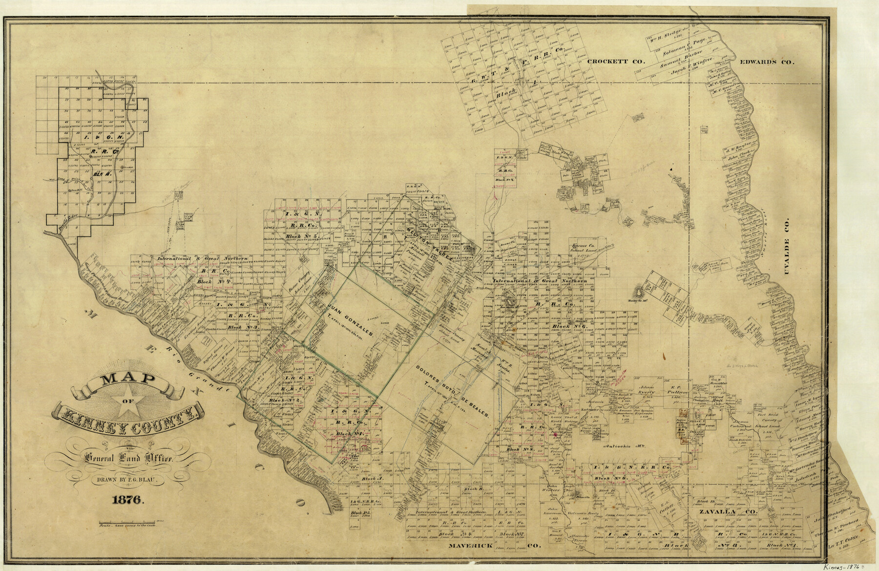
Map of Kinney County
-
Map/Doc
3776
-
Collection
General Map Collection
-
Object Dates
1876 (Creation Date)
-
People and Organizations
F.G. Blau (Draftsman)
-
Counties
Kinney
-
Subjects
County
-
Height x Width
24.8 x 37.8 inches
63.0 x 96.0 cm
-
Features
Turkey Creek
Brackett
Fort Clark
Zoquete Creek
Piedra Pinto Creek
San Pedro Creek
Sacattecosa Creek
Fort Stockton & Fort Clark Road
Fort Stockton Road
Fort Clark Road
Conical Hill
San Felipe
San Felipe Creek
Rio Grande
Stampede Creek
San Antonio Stage Road
[Road] to West Fork of Nueces River
Lindsey Creek
Las Moras Creek
Cow Creek
Salado Creek
Chacon Creek
Sycamore Creek
[Road] to Griffin Valley
Peloncillo [Mountain]
Rusk Trail
Woodhull Creek
Chaparosa Creek
Muela Creek
Gato Creek
Pope Lake [Creek]
Grass Valley Creek
West Prong of Painted Cave Creek
Devil's River
Lone Hill
West Fork of Nueces River
Griffin Creek
E[ast] P[rong] of San Pedro Arroyo
Sienegas Creek
Middle Fork [of Sycamore Creek]
West Fork [of Sycamore Creek]
West Fork [of Xoquete Creek]
West Fork [of Piedra Pinta Creek]
East Fork [of Piedra Pinta Creek]
East Fork [of Xoquete Creek]
Pinto Mountain
Painted Cave Creek
West Prong of Nueces River
Live Oak Creek
Nueces River
Turkey Creek Mountain
Olmos Mountan
Elm Creek
Arenosa Creek
[Road] to Nueces River & Fort McKavett
[Road] to Nueces River
[Road] to Fort McKavett
Las Moras Mountain
Little Pinto Mountain
Bluff Creek
Griffin Valley Creek
Part of: General Map Collection
McMullen County Working Sketch 32

Print $20.00
- Digital $50.00
McMullen County Working Sketch 32
1958
Size 28.2 x 32.5 inches
Map/Doc 70733
Coke County Boundary File 5

Print $36.00
- Digital $50.00
Coke County Boundary File 5
Size 7.7 x 37.9 inches
Map/Doc 51606
Leon County Rolled Sketch 14

Print $20.00
- Digital $50.00
Leon County Rolled Sketch 14
1976
Size 33.4 x 27.9 inches
Map/Doc 9432
Schleicher County Working Sketch 12

Print $20.00
- Digital $50.00
Schleicher County Working Sketch 12
1925
Size 23.7 x 22.2 inches
Map/Doc 63814
Terrell County Rolled Sketch JAS

Print $40.00
- Digital $50.00
Terrell County Rolled Sketch JAS
1936
Size 48.5 x 40.0 inches
Map/Doc 9988
Gregg County Boundary File 6

Print $6.00
- Digital $50.00
Gregg County Boundary File 6
Size 8.5 x 5.8 inches
Map/Doc 54001
Crockett County Sketch File 44

Print $8.00
- Digital $50.00
Crockett County Sketch File 44
1881
Size 12.8 x 8.8 inches
Map/Doc 19768

Trinity County Sketch File 24

Print $4.00
- Digital $50.00
Trinity County Sketch File 24
Size 7.5 x 10.5 inches
Map/Doc 38556
[San Antonio & Aransas Pass]
![64211, [San Antonio & Aransas Pass], General Map Collection](https://historictexasmaps.com/wmedia_w700/maps/64211.tif.jpg)
Print $2.00
- Digital $50.00
[San Antonio & Aransas Pass]
Size 11.6 x 8.2 inches
Map/Doc 64211
Duval County Working Sketch 23

Print $20.00
- Digital $50.00
Duval County Working Sketch 23
1943
Size 41.8 x 37.8 inches
Map/Doc 68747
You may also like
Jasper County Sketch File 31

Print $20.00
- Digital $50.00
Jasper County Sketch File 31
Size 21.6 x 24.7 inches
Map/Doc 11852
[Blocks J, 24, 5, 8, 2, 1 and vicinity]
![92663, [Blocks J, 24, 5, 8, 2, 1 and vicinity], Twichell Survey Records](https://historictexasmaps.com/wmedia_w700/maps/92663-1.tif.jpg)
Print $40.00
- Digital $50.00
[Blocks J, 24, 5, 8, 2, 1 and vicinity]
Size 54.0 x 32.2 inches
Map/Doc 92663
Wise County Rolled Sketch 9

Print $20.00
- Digital $50.00
Wise County Rolled Sketch 9
Size 35.2 x 24.2 inches
Map/Doc 93640
Fort Bend County Sketch File 21

Print $4.00
- Digital $50.00
Fort Bend County Sketch File 21
1882
Size 8.8 x 13.4 inches
Map/Doc 22954
Map of Perico, Dallam County, Texas

Print $20.00
- Digital $50.00
Map of Perico, Dallam County, Texas
Size 20.1 x 16.7 inches
Map/Doc 92128
Milam County Working Sketch 11

Print $20.00
- Digital $50.00
Milam County Working Sketch 11
1987
Size 43.8 x 31.9 inches
Map/Doc 71026
Brazos Island Harbor, Texas - Dredging Entrance Channel Plan

Print $20.00
- Digital $50.00
Brazos Island Harbor, Texas - Dredging Entrance Channel Plan
1990
Size 14.6 x 20.0 inches
Map/Doc 83337
Zavala County Sketch File 34

Print $4.00
- Digital $50.00
Zavala County Sketch File 34
1887
Size 13.0 x 8.5 inches
Map/Doc 41395
Shackelford County Sketch File 1

Print $4.00
- Digital $50.00
Shackelford County Sketch File 1
1877
Size 12.8 x 8.0 inches
Map/Doc 36570
Tarrant County Sketch File 26

Print $24.00
- Digital $50.00
Tarrant County Sketch File 26
1874
Size 12.7 x 8.4 inches
Map/Doc 37739
Stephens County Working Sketch 34

Print $20.00
- Digital $50.00
Stephens County Working Sketch 34
1978
Size 33.5 x 28.3 inches
Map/Doc 63977
Map of La Salle County

Print $20.00
- Digital $50.00
Map of La Salle County
1878
Size 29.8 x 24.8 inches
Map/Doc 3798