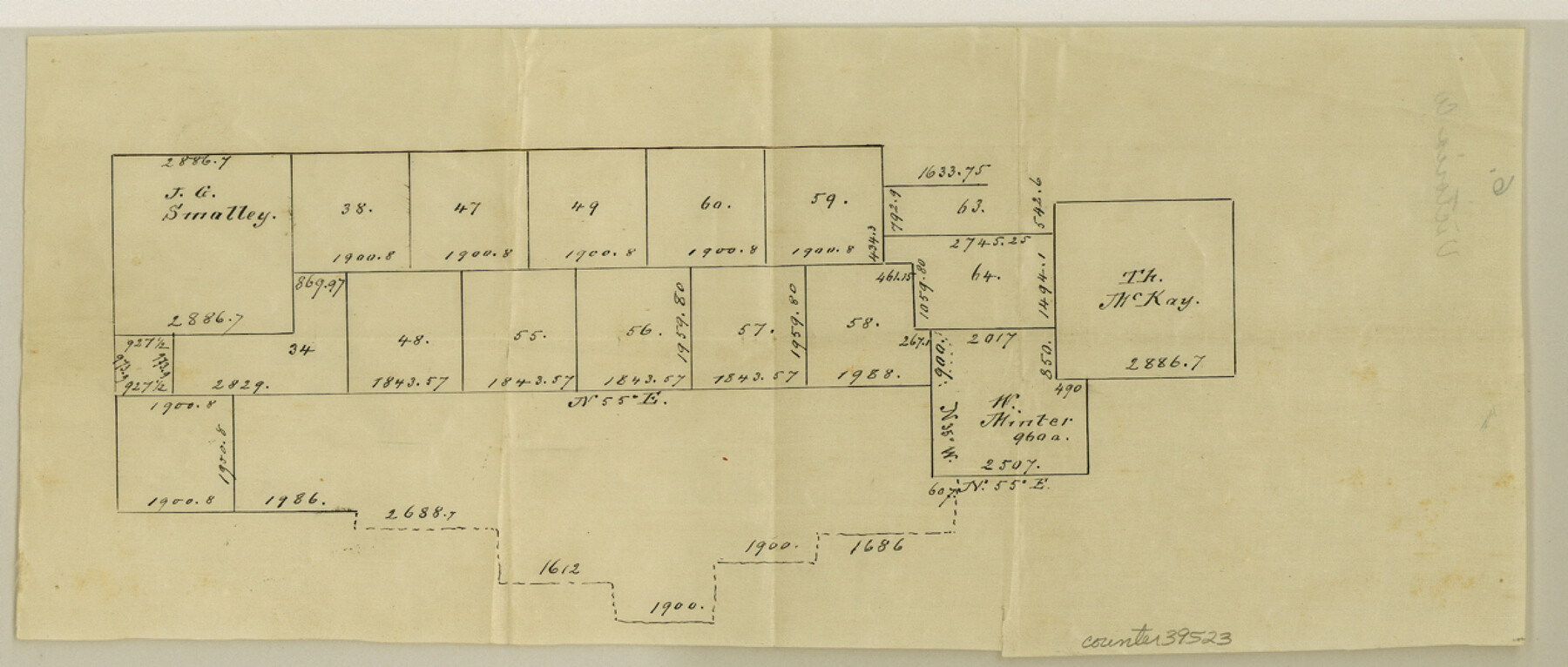
Victoria County Sketch File 6
[Skeleton sketch of surveys between the J.G. Smalley and Thomas McKay surveys in the northeast part of the county]
-
Map/Doc
39523
-
Collection
General Map Collection
-
Counties
Victoria
-
Subjects
Surveying Sketch File
-
Height x Width
5.3 x 12.5 inches
13.5 x 31.8 cm
-
Medium
paper, manuscript
Part of: General Map Collection
Bosque County, Milam District

Print $20.00
- Digital $50.00
Bosque County, Milam District
1876
Size 24.0 x 29.1 inches
Map/Doc 1519
McMullen County Working Sketch 24

Print $20.00
- Digital $50.00
McMullen County Working Sketch 24
1950
Size 31.5 x 31.0 inches
Map/Doc 70725
Flight Mission No. CRC-3R, Frame 28, Chambers County

Print $20.00
- Digital $50.00
Flight Mission No. CRC-3R, Frame 28, Chambers County
1956
Size 18.8 x 22.4 inches
Map/Doc 84803
Controlled Mosaic by Jack Amman Photogrammetric Engineers, Inc - Sheet 15

Print $20.00
- Digital $50.00
Controlled Mosaic by Jack Amman Photogrammetric Engineers, Inc - Sheet 15
1954
Size 20.0 x 24.0 inches
Map/Doc 83459
Flight Mission No. DQN-2K, Frame 81, Calhoun County

Print $20.00
- Digital $50.00
Flight Mission No. DQN-2K, Frame 81, Calhoun County
1953
Size 18.7 x 22.3 inches
Map/Doc 84273
City of San Francisco and its Vicinity, California

Print $20.00
- Digital $50.00
City of San Francisco and its Vicinity, California
1853
Size 28.1 x 20.4 inches
Map/Doc 97233
Flight Mission No. BRA-16M, Frame 54, Jefferson County

Print $20.00
- Digital $50.00
Flight Mission No. BRA-16M, Frame 54, Jefferson County
1953
Size 18.5 x 22.5 inches
Map/Doc 85671
Houston County Sketch File 43

Print $4.00
- Digital $50.00
Houston County Sketch File 43
1845
Size 5.5 x 7.8 inches
Map/Doc 26832
Outer Continental Shelf Leasing Map, Texas

Print $20.00
- Digital $50.00
Outer Continental Shelf Leasing Map, Texas
1954
Size 17.3 x 22.2 inches
Map/Doc 75832
Roberts County Working Sketch 6

Print $20.00
- Digital $50.00
Roberts County Working Sketch 6
1952
Size 29.3 x 21.9 inches
Map/Doc 63532
Edwards County Rolled Sketch 21

Print $20.00
- Digital $50.00
Edwards County Rolled Sketch 21
1948
Size 17.0 x 29.4 inches
Map/Doc 5809
Travis County Rolled Sketch 56

Print $20.00
- Digital $50.00
Travis County Rolled Sketch 56
1885
Size 16.7 x 23.2 inches
Map/Doc 8047
You may also like
Township No. 7 South Range No. 4 West of the Indian Meridian, Chickasaw Lands

Print $4.00
- Digital $50.00
Township No. 7 South Range No. 4 West of the Indian Meridian, Chickasaw Lands
1871
Size 18.2 x 22.4 inches
Map/Doc 75146
El Paso County Rolled Sketch 58

Print $20.00
- Digital $50.00
El Paso County Rolled Sketch 58
1987
Size 18.6 x 24.6 inches
Map/Doc 5851
Flight Mission No. CGI-3N, Frame 182, Cameron County

Print $20.00
- Digital $50.00
Flight Mission No. CGI-3N, Frame 182, Cameron County
1954
Size 18.7 x 22.3 inches
Map/Doc 84646
Hamilton County Working Sketch 1

Print $20.00
- Digital $50.00
Hamilton County Working Sketch 1
1914
Size 17.7 x 17.8 inches
Map/Doc 63339
Pecos County Sketch File 20

Print $20.00
- Digital $50.00
Pecos County Sketch File 20
Size 25.9 x 12.0 inches
Map/Doc 12160
Tarrant County Working Sketch 3

Print $20.00
- Digital $50.00
Tarrant County Working Sketch 3
1948
Size 26.3 x 24.9 inches
Map/Doc 62420
Orange County Working Sketch 8

Print $20.00
- Digital $50.00
Orange County Working Sketch 8
1922
Size 20.7 x 24.3 inches
Map/Doc 71340
Red River County Working Sketch 34

Print $20.00
- Digital $50.00
Red River County Working Sketch 34
1963
Size 25.8 x 33.1 inches
Map/Doc 72017
Yoakum County Working Sketch Graphic Index

Print $20.00
- Digital $50.00
Yoakum County Working Sketch Graphic Index
1932
Size 44.7 x 33.1 inches
Map/Doc 76747
Reagan County Rolled Sketch 17

Print $20.00
- Digital $50.00
Reagan County Rolled Sketch 17
Size 33.9 x 32.6 inches
Map/Doc 10623
Crane County Working Sketch 16

Print $20.00
- Digital $50.00
Crane County Working Sketch 16
1955
Size 42.8 x 22.0 inches
Map/Doc 68293
Kinney County Sketch File 36

Print $20.00
- Digital $50.00
Kinney County Sketch File 36
1946
Size 19.2 x 22.0 inches
Map/Doc 11949