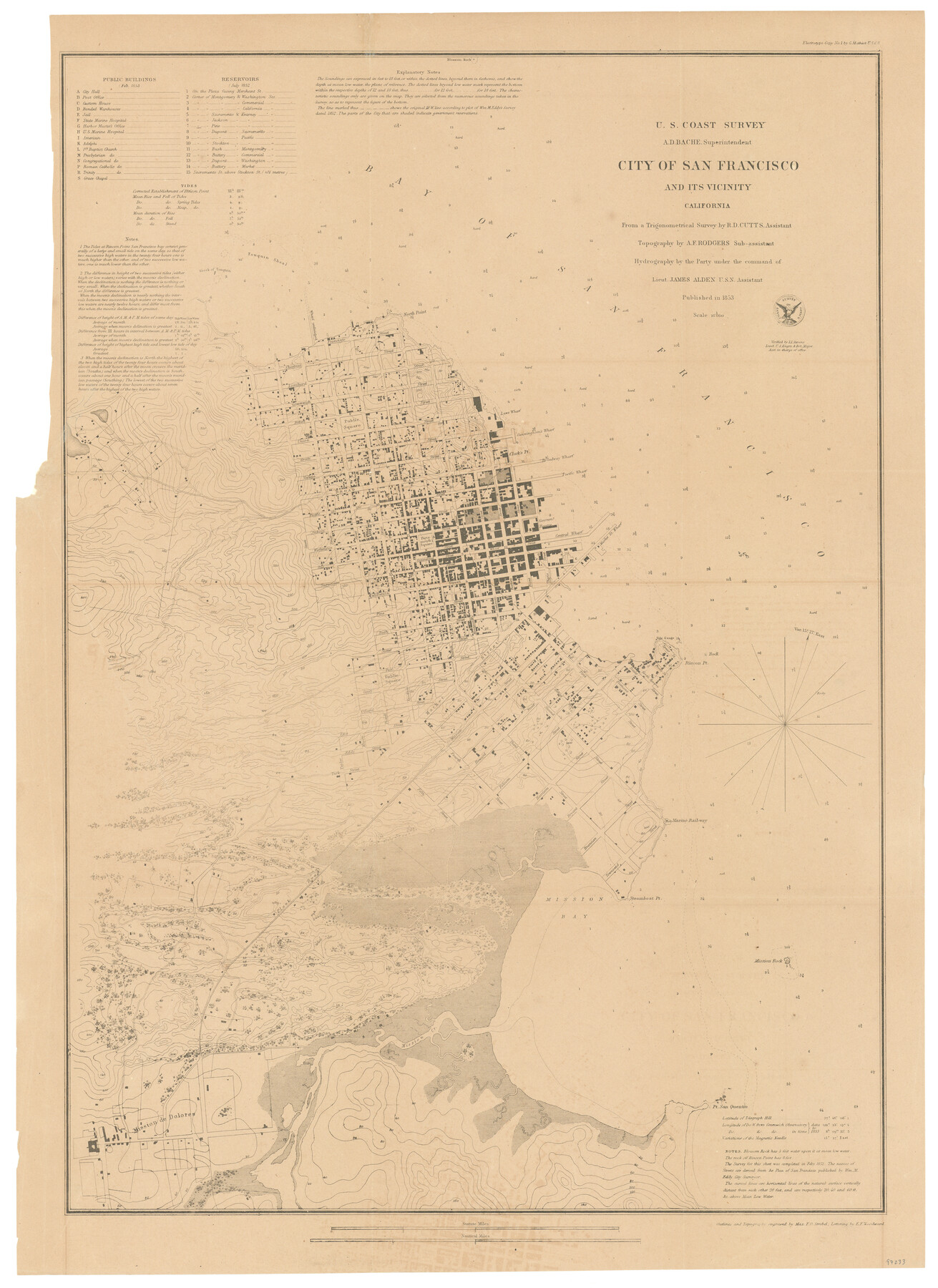
City of San Francisco and its Vicinity, California
-
Map/Doc
97233
-
Collection
General Map Collection
-
Object Dates
1853 (Creation Date)
-
People and Organizations
A.D. Bache (Superintendent)
R.D. Cutts (Surveyor/Engineer)
A.F. Rodgers (Surveyor/Engineer)
James Alden (Surveyor/Engineer)
I.I. Stevens (Surveyor/Engineer)
U.S. Coast Survey (Publisher)
-
Subjects
Coastal
-
Height x Width
28.1 x 20.4 inches
71.4 x 51.8 cm
-
Comments
Sketch from the book "Report of the Superintendent of the Coast Survey Showing the Progress of the Survey in the year 1852" (81738)
Related maps
Report of the Superintendent of the Coast Survey showing the progress of the survey during the year 1852

Report of the Superintendent of the Coast Survey showing the progress of the survey during the year 1852
1853
Map/Doc 81738
Part of: General Map Collection
Hansford County Working Sketch 9

Print $20.00
- Digital $50.00
Hansford County Working Sketch 9
1984
Size 31.5 x 38.2 inches
Map/Doc 63381
Bexar County Working Sketch 19

Print $20.00
- Digital $50.00
Bexar County Working Sketch 19
1982
Size 41.8 x 41.7 inches
Map/Doc 67335
Leon County Sketch File 2

Print $4.00
- Digital $50.00
Leon County Sketch File 2
1852
Size 8.1 x 5.1 inches
Map/Doc 29711
Jackson County Rolled Sketch 7

Print $20.00
- Digital $50.00
Jackson County Rolled Sketch 7
1940
Size 23.0 x 32.2 inches
Map/Doc 6342
Terrell County Working Sketch 82

Print $20.00
- Digital $50.00
Terrell County Working Sketch 82
1991
Size 31.7 x 24.8 inches
Map/Doc 69603
Shelby County Sketch File 22

Print $6.00
- Digital $50.00
Shelby County Sketch File 22
Size 15.4 x 10.2 inches
Map/Doc 36643
[Abstract Numbering Register - Donley through Karnes]
![82966, [Abstract Numbering Register - Donley through Karnes], General Map Collection](https://historictexasmaps.com/wmedia_w700/pdf_converted_jpg/qi_pdf_thumbnail_30613.jpg)
[Abstract Numbering Register - Donley through Karnes]
Map/Doc 82966
Map of Lee County Texas

Print $20.00
- Digital $50.00
Map of Lee County Texas
1879
Size 26.2 x 18.0 inches
Map/Doc 4578
Texas for Tourists, a highway and reference map published by the Dallas Morning News for the Texas Almanac and State Industrial Guide

Texas for Tourists, a highway and reference map published by the Dallas Morning News for the Texas Almanac and State Industrial Guide
1936
Size 20.3 x 26.4 inches
Map/Doc 94294
Eastland County Working Sketch 64

Print $40.00
- Digital $50.00
Eastland County Working Sketch 64
1983
Size 43.3 x 68.4 inches
Map/Doc 88891
Polk County Sketch File 41

Print $10.00
- Digital $50.00
Polk County Sketch File 41
Size 12.7 x 8.2 inches
Map/Doc 34292
Culberson County Working Sketch 4

Print $20.00
- Digital $50.00
Culberson County Working Sketch 4
Size 37.7 x 32.2 inches
Map/Doc 68456
You may also like
Polk County Sketch File 40

Print $4.00
- Digital $50.00
Polk County Sketch File 40
Size 10.9 x 8.5 inches
Map/Doc 34290
Kent County Sketch File 4

Print $20.00
- Digital $50.00
Kent County Sketch File 4
Size 27.5 x 28.3 inches
Map/Doc 11912
Pecos County Rolled Sketch 156

Print $40.00
- Digital $50.00
Pecos County Rolled Sketch 156
1938
Size 39.7 x 48.1 inches
Map/Doc 9738
Wichita County Sketch File 8

Print $4.00
- Digital $50.00
Wichita County Sketch File 8
1860
Size 11.7 x 8.2 inches
Map/Doc 40048
[Leagues 589-598, 627-630, part of Black Water Pasture]
![90259, [Leagues 589-598, 627-630, part of Black Water Pasture], Twichell Survey Records](https://historictexasmaps.com/wmedia_w700/maps/90259-1.tif.jpg)
Print $3.00
- Digital $50.00
[Leagues 589-598, 627-630, part of Black Water Pasture]
Size 14.5 x 11.5 inches
Map/Doc 90259
Williamson County Working Sketch 10

Print $20.00
- Digital $50.00
Williamson County Working Sketch 10
1961
Size 31.1 x 20.0 inches
Map/Doc 72570
Jasper County Working Sketch 22

Print $20.00
- Digital $50.00
Jasper County Working Sketch 22
1943
Size 21.0 x 15.4 inches
Map/Doc 66484
Dimmit County Working Sketch 33

Print $40.00
- Digital $50.00
Dimmit County Working Sketch 33
1959
Size 27.0 x 53.8 inches
Map/Doc 68694
Hardeman County Sketch File 31

Print $4.00
- Digital $50.00
Hardeman County Sketch File 31
Size 14.5 x 9.0 inches
Map/Doc 25066
Hardin County Sketch File 11

Print $8.00
- Digital $50.00
Hardin County Sketch File 11
Size 5.2 x 8.2 inches
Map/Doc 25112
Trinity County Sketch File 5b

Print $4.00
- Digital $50.00
Trinity County Sketch File 5b
1855
Size 12.6 x 8.0 inches
Map/Doc 38506
Presidio County Rolled Sketch 30

Print $40.00
- Digital $50.00
Presidio County Rolled Sketch 30
Size 40.8 x 84.9 inches
Map/Doc 9767