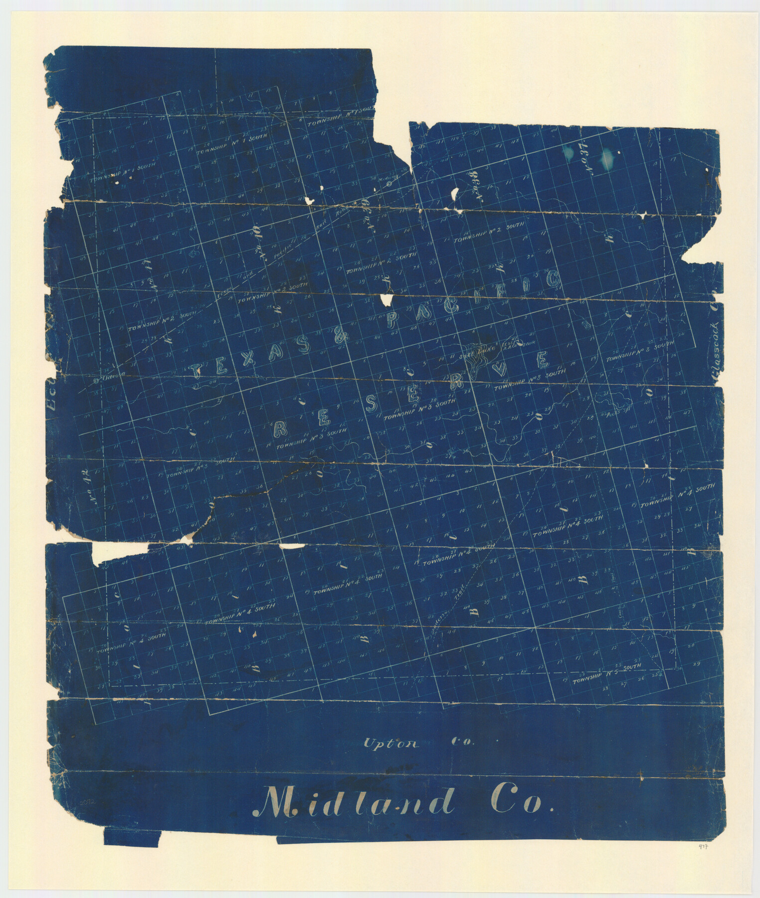
Midland County, Texas
-
Map/Doc
437
-
Collection
Maddox Collection
-
Object Dates
[1880 ca.] (Creation Date)
-
People and Organizations
General Land Office (Publisher)
-
Counties
Midland
-
Subjects
County
-
Height x Width
20.8 x 17.7 inches
52.8 x 45.0 cm
-
Medium
blueprint/diazo
-
Comments
Copy of lithograph. Conservation funded in 2011.
-
Features
Midway
T&P
Salt Lake
Odessa
Pecks Spr[ing]
Fort Concho Trail
Shafters Trail
Part of: Maddox Collection
Plat of a portion of Buchel County, Texas

Print $20.00
- Digital $50.00
Plat of a portion of Buchel County, Texas
Size 16.0 x 26.2 inches
Map/Doc 82526
Survey of Lots 1, 2, 3, 4 and 5, Block 12G Fair View Park, Austin Texas

Print $20.00
- Digital $50.00
Survey of Lots 1, 2, 3, 4 and 5, Block 12G Fair View Park, Austin Texas
1914
Size 23.1 x 11.0 inches
Map/Doc 83431
Mitchell County, Texas

Print $20.00
- Digital $50.00
Mitchell County, Texas
1870
Size 22.7 x 18.0 inches
Map/Doc 741
[Upton County Sketch]
![5043, [Upton County Sketch], Maddox Collection](https://historictexasmaps.com/wmedia_w700/maps/5043-1.tif.jpg)
Print $40.00
- Digital $50.00
[Upton County Sketch]
Size 19.2 x 60.3 inches
Map/Doc 5043
Skeleton Map of Nueces County

Print $20.00
- Digital $50.00
Skeleton Map of Nueces County
Size 35.5 x 39.4 inches
Map/Doc 592
Hansford County, Texas

Print $20.00
- Digital $50.00
Hansford County, Texas
1888
Size 22.5 x 17.8 inches
Map/Doc 731
Map showing conflict of Rusk Transportation Co. with Lazarus and I. R.R. Co. Surveys

Print $20.00
- Digital $50.00
Map showing conflict of Rusk Transportation Co. with Lazarus and I. R.R. Co. Surveys
1914
Size 28.9 x 16.6 inches
Map/Doc 75825
[Highway Map of the State of Texas]
![5039, [Highway Map of the State of Texas], Maddox Collection](https://historictexasmaps.com/wmedia_w700/maps/5039-1.tif.jpg)
Print $20.00
- Digital $50.00
[Highway Map of the State of Texas]
1923
Size 44.7 x 46.7 inches
Map/Doc 5039
[Sketch showing Miguel Perez, Juan Jose Solis and Francisco Antonio Villareal surveys in Starr County]
![75549, [Sketch showing Miguel Perez, Juan Jose Solis and Francisco Antonio Villareal surveys in Starr County], Maddox Collection](https://historictexasmaps.com/wmedia_w700/maps/75549.tif.jpg)
Print $20.00
- Digital $50.00
[Sketch showing Miguel Perez, Juan Jose Solis and Francisco Antonio Villareal surveys in Starr County]
1914
Size 20.9 x 13.6 inches
Map/Doc 75549
Rough sketch showing survey made for L.T. Eck Block 14 and part of Block 13, Fairview Park, South Austin, Texas

Print $2.00
- Digital $50.00
Rough sketch showing survey made for L.T. Eck Block 14 and part of Block 13, Fairview Park, South Austin, Texas
1914
Size 9.0 x 14.4 inches
Map/Doc 467
Camp County, Texas

Print $3.00
- Digital $50.00
Camp County, Texas
1879
Size 9.6 x 16.8 inches
Map/Doc 512

You may also like
El Paso County

Print $40.00
- Digital $50.00
El Paso County
1881
Size 51.5 x 15.7 inches
Map/Doc 89057
Reeves County Working Sketch 4a

Print $20.00
- Digital $50.00
Reeves County Working Sketch 4a
1933
Size 26.0 x 34.6 inches
Map/Doc 63447
Nueces County Rolled Sketch 76

Print $20.00
- Digital $50.00
Nueces County Rolled Sketch 76
1981
Size 18.3 x 23.6 inches
Map/Doc 6937
Crockett County Sketch File 39

Print $20.00
- Digital $50.00
Crockett County Sketch File 39
1889
Size 19.7 x 32.6 inches
Map/Doc 11221
Ochiltree County Working Sketch 1

Print $20.00
- Digital $50.00
Ochiltree County Working Sketch 1
1954
Size 16.7 x 11.6 inches
Map/Doc 71314
Hunt County Boundary File 5

Print $6.00
- Digital $50.00
Hunt County Boundary File 5
Size 11.2 x 8.9 inches
Map/Doc 55222
McCulloch County Working Sketch 12

Print $20.00
- Digital $50.00
McCulloch County Working Sketch 12
1982
Size 37.5 x 20.1 inches
Map/Doc 70687
Concho County Rolled Sketch 11

Print $20.00
- Digital $50.00
Concho County Rolled Sketch 11
1957
Size 29.5 x 34.5 inches
Map/Doc 5569
Lamar County Sketch File 14

Print $4.00
- Digital $50.00
Lamar County Sketch File 14
1873
Size 12.7 x 8.1 inches
Map/Doc 29308
Flight Mission No. CLL-1N, Frame 78, Willacy County

Print $20.00
- Digital $50.00
Flight Mission No. CLL-1N, Frame 78, Willacy County
1954
Size 18.4 x 22.1 inches
Map/Doc 87024

Flight Mission No. DQO-2K, Frame 149, Galveston County

Print $20.00
- Digital $50.00
Flight Mission No. DQO-2K, Frame 149, Galveston County
1952
Size 18.8 x 22.4 inches
Map/Doc 85046