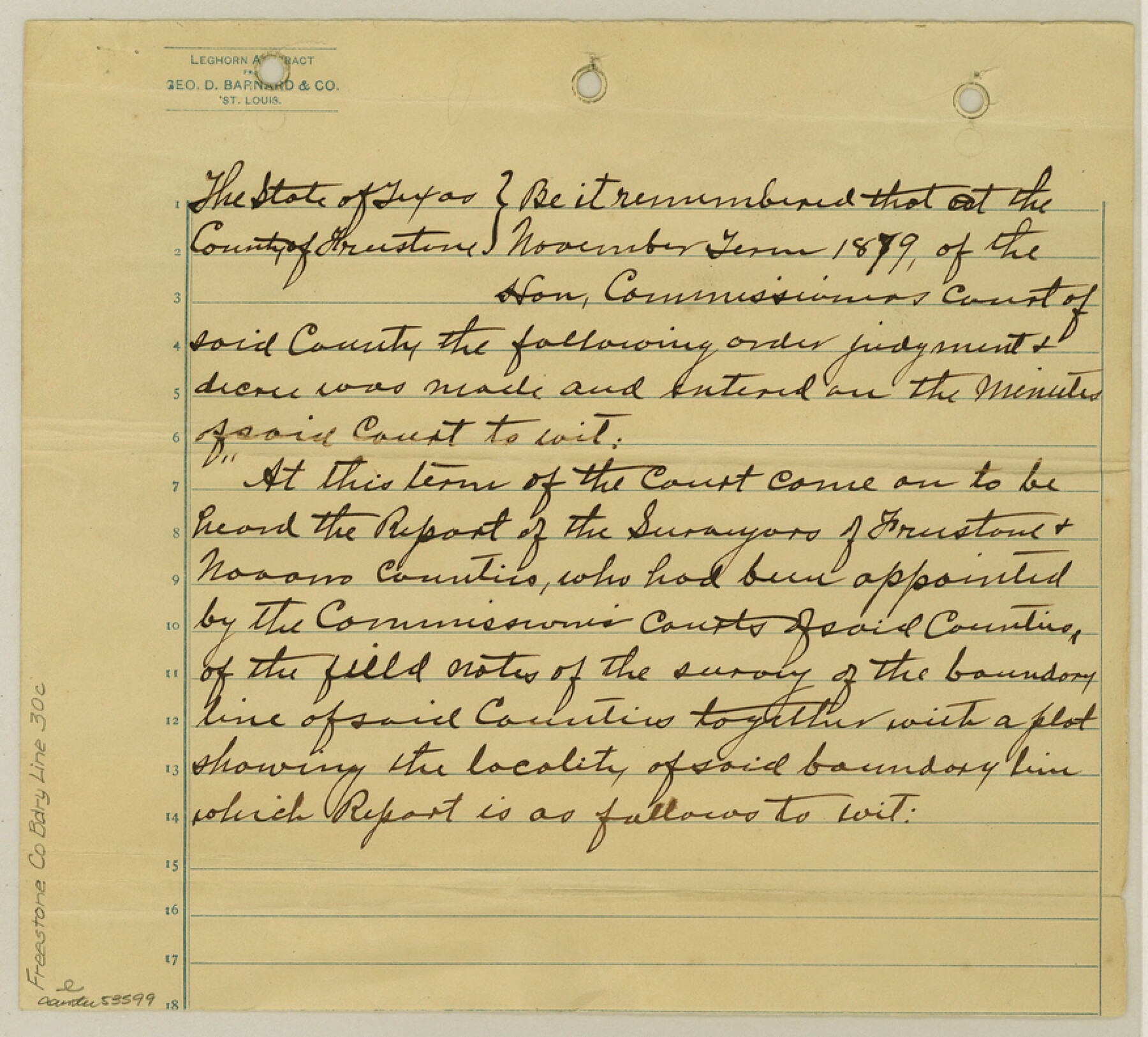
Freestone County Boundary File 30c
Report of Surveyors and Field Notes of Survey of Freestone & Navarro Boundary
-
Map/Doc
53599
-
Collection
General Map Collection
-
Counties
Freestone
-
Subjects
County Boundaries
-
Height x Width
7.9 x 8.8 inches
20.1 x 22.4 cm
Part of: General Map Collection
Trinity River, Post Oak Creek Sheet

Print $4.00
- Digital $50.00
Trinity River, Post Oak Creek Sheet
1930
Size 20.6 x 23.0 inches
Map/Doc 65227
Flight Mission No. CRK-8P, Frame 101, Refugio County

Print $20.00
- Digital $50.00
Flight Mission No. CRK-8P, Frame 101, Refugio County
1956
Size 18.7 x 22.3 inches
Map/Doc 86962
Kendall County Working Sketch 22

Print $20.00
- Digital $50.00
Kendall County Working Sketch 22
1971
Size 41.6 x 34.7 inches
Map/Doc 66694
El Paso County Sketch File 33

Print $2.00
- Digital $50.00
El Paso County Sketch File 33
1983
Size 9.0 x 14.5 inches
Map/Doc 22128
Montgomery County Sketch File 1

Print $4.00
- Digital $50.00
Montgomery County Sketch File 1
Size 11.4 x 8.0 inches
Map/Doc 31762
Freestone County Sketch File 22a

Print $20.00
- Digital $50.00
Freestone County Sketch File 22a
Size 17.8 x 18.1 inches
Map/Doc 11516
Sterling County Rolled Sketch 28

Print $20.00
- Digital $50.00
Sterling County Rolled Sketch 28
Size 28.8 x 33.4 inches
Map/Doc 7853

Liberty County Rolled Sketch 15

Print $20.00
- Digital $50.00
Liberty County Rolled Sketch 15
2015
Size 36.1 x 24.4 inches
Map/Doc 94023
Moore County Working Sketch 9

Print $20.00
- Digital $50.00
Moore County Working Sketch 9
1950
Size 38.5 x 31.8 inches
Map/Doc 71191
Montgomery County Sketch File 36a

Print $8.00
- Digital $50.00
Montgomery County Sketch File 36a
1953
Size 14.4 x 8.8 inches
Map/Doc 31912
Brazoria County Sketch File 38

Print $40.00
- Digital $50.00
Brazoria County Sketch File 38
1917
Size 17.1 x 14.5 inches
Map/Doc 15043
You may also like
Val Verde County Working Sketch 68

Print $20.00
- Digital $50.00
Val Verde County Working Sketch 68
1965
Size 37.3 x 44.2 inches
Map/Doc 72203
Amistad International Reservoir on Rio Grande 84

Print $20.00
- Digital $50.00
Amistad International Reservoir on Rio Grande 84
1949
Size 28.4 x 40.2 inches
Map/Doc 75513
Kinney County Rolled Sketch 16

Print $20.00
- Digital $50.00
Kinney County Rolled Sketch 16
1963
Size 36.4 x 43.8 inches
Map/Doc 9356
Kleberg County Rolled Sketch 10-17

Print $20.00
- Digital $50.00
Kleberg County Rolled Sketch 10-17
1951
Size 38.1 x 32.0 inches
Map/Doc 9390
Blanco County Working Sketch 41

Print $20.00
- Digital $50.00
Blanco County Working Sketch 41
1986
Size 28.4 x 25.2 inches
Map/Doc 67401
Val Verde County Rolled Sketch 73

Print $20.00
- Digital $50.00
Val Verde County Rolled Sketch 73
1960
Size 15.0 x 19.4 inches
Map/Doc 8136
Flight Mission No. DQO-2K, Frame 84, Galveston County

Print $20.00
- Digital $50.00
Flight Mission No. DQO-2K, Frame 84, Galveston County
1952
Size 18.8 x 22.5 inches
Map/Doc 85011
Controlled Mosaic by Jack Amman Photogrammetric Engineers, Inc - Sheet 52

Print $20.00
- Digital $50.00
Controlled Mosaic by Jack Amman Photogrammetric Engineers, Inc - Sheet 52
1954
Size 20.0 x 24.0 inches
Map/Doc 83511
2008 Official Travel Map Texas

Digital $50.00
2008 Official Travel Map Texas
Size 33.4 x 36.5 inches
Map/Doc 94310
Nacogdoches County Sketch File 2

Print $4.00
- Digital $50.00
Nacogdoches County Sketch File 2
1852
Size 8.0 x 6.4 inches
Map/Doc 32235
Williamson County

Print $40.00
- Digital $50.00
Williamson County
1946
Size 39.0 x 56.3 inches
Map/Doc 73326
Lavaca County Rolled Sketch 2

Print $20.00
- Digital $50.00
Lavaca County Rolled Sketch 2
1951
Size 37.0 x 26.7 inches
Map/Doc 6592