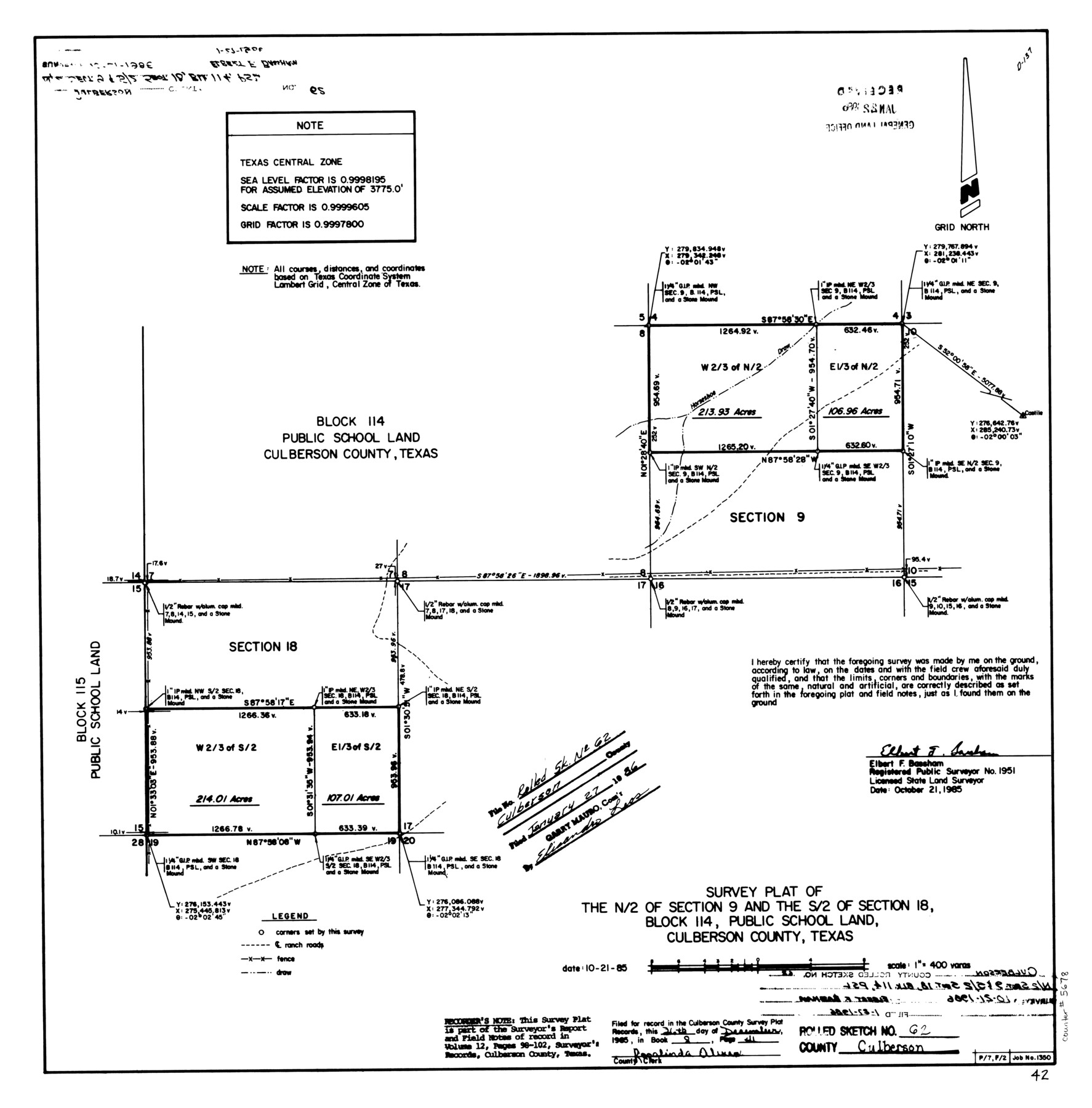
Culberson County Rolled Sketch 62
Survey plat of the N/2 of section 9 and the S/2 of section 18, Block 114, Public School Land, Culberson County, Texas
-
Map/Doc
5678
-
Collection
General Map Collection
-
Object Dates
1985/10/21 (Creation Date)
1986/1/27 (File Date)
-
People and Organizations
Elbert F. Bassham (Surveyor/Engineer)
-
Counties
Culberson
-
Subjects
Surveying Rolled Sketch
-
Height x Width
20.8 x 20.5 inches
52.8 x 52.1 cm
-
Scale
1" = 400 varas
Part of: General Map Collection
Outer Continental Shelf Leasing Maps (Texas Offshore Operations)

Print $20.00
- Digital $50.00
Outer Continental Shelf Leasing Maps (Texas Offshore Operations)
Size 17.6 x 13.6 inches
Map/Doc 75850
Map of Panola County

Print $20.00
- Digital $50.00
Map of Panola County
1897
Size 39.5 x 39.1 inches
Map/Doc 66967
Angelina County Working Sketch 19

Print $20.00
- Digital $50.00
Angelina County Working Sketch 19
1946
Size 35.8 x 39.3 inches
Map/Doc 67100
Red River County Working Sketch 60

Print $20.00
- Digital $50.00
Red River County Working Sketch 60
1973
Size 27.1 x 40.0 inches
Map/Doc 72043
Reagan County Working Sketch 29

Print $40.00
- Digital $50.00
Reagan County Working Sketch 29
1963
Size 34.3 x 66.4 inches
Map/Doc 71871
Wichita County Rolled Sketch 18

Print $20.00
- Digital $50.00
Wichita County Rolled Sketch 18
1924
Size 30.0 x 40.5 inches
Map/Doc 8253
Map of Dallas County Showing Location of Texas and Pacific Railway

Print $20.00
- Digital $50.00
Map of Dallas County Showing Location of Texas and Pacific Railway
1872
Size 25.2 x 21.4 inches
Map/Doc 64134
Scurry County Rolled Sketch 10

Print $20.00
- Digital $50.00
Scurry County Rolled Sketch 10
1966
Size 22.7 x 18.3 inches
Map/Doc 7770
Flight Mission No. DQN-5K, Frame 48, Calhoun County

Print $20.00
- Digital $50.00
Flight Mission No. DQN-5K, Frame 48, Calhoun County
1953
Size 18.7 x 22.2 inches
Map/Doc 84393
Swisher County Working Sketch 6

Print $20.00
- Digital $50.00
Swisher County Working Sketch 6
1979
Size 23.2 x 19.7 inches
Map/Doc 62417
Terrell County Working Sketch 51

Print $40.00
- Digital $50.00
Terrell County Working Sketch 51
1958
Size 63.7 x 43.6 inches
Map/Doc 62144
Dallas County Sketch File 14

Print $22.00
- Digital $50.00
Dallas County Sketch File 14
1859
Size 8.2 x 7.6 inches
Map/Doc 20428
You may also like
Grimes County Working Sketch 8

Print $20.00
- Digital $50.00
Grimes County Working Sketch 8
1976
Size 35.0 x 32.7 inches
Map/Doc 63299
Flight Mission No. DIX-6P, Frame 128, Aransas County

Print $20.00
- Digital $50.00
Flight Mission No. DIX-6P, Frame 128, Aransas County
1956
Size 19.2 x 22.6 inches
Map/Doc 83834
Wise County Sketch File 3

Print $4.00
- Digital $50.00
Wise County Sketch File 3
1856
Size 10.2 x 8.0 inches
Map/Doc 40528
Dawson County Working Sketch 3

Print $20.00
- Digital $50.00
Dawson County Working Sketch 3
1920
Size 16.1 x 14.8 inches
Map/Doc 68547
Fort Bend County Sketch File 9

Print $20.00
- Digital $50.00
Fort Bend County Sketch File 9
Size 18.8 x 16.5 inches
Map/Doc 11500
Mills County Boundary File 5

Print $8.00
- Digital $50.00
Mills County Boundary File 5
Size 14.2 x 8.7 inches
Map/Doc 57296
Angelina County Sketch File 4

Print $4.00
- Digital $50.00
Angelina County Sketch File 4
1854
Size 8.3 x 9.0 inches
Map/Doc 12926
Midland County Sketch File 1

Print $20.00
- Digital $50.00
Midland County Sketch File 1
1886
Size 25.7 x 16.1 inches
Map/Doc 12079
Reagan County Sketch File 2A

Print $6.00
- Digital $50.00
Reagan County Sketch File 2A
1882
Size 9.1 x 17.6 inches
Map/Doc 12211
Martin County Boundary File 62

Print $110.00
- Digital $50.00
Martin County Boundary File 62
Size 8.7 x 4.0 inches
Map/Doc 56782
Lake Corpus Christi and a city map of Mathis, Texas [Verso]
![94171, Lake Corpus Christi and a city map of Mathis, Texas [Verso], General Map Collection](https://historictexasmaps.com/wmedia_w700/maps/94171.tif.jpg)
Lake Corpus Christi and a city map of Mathis, Texas [Verso]
1984
Size 29.3 x 22.9 inches
Map/Doc 94171
Map of Lamar County

Print $20.00
- Digital $50.00
Map of Lamar County
1849
Size 25.7 x 26.8 inches
Map/Doc 1236