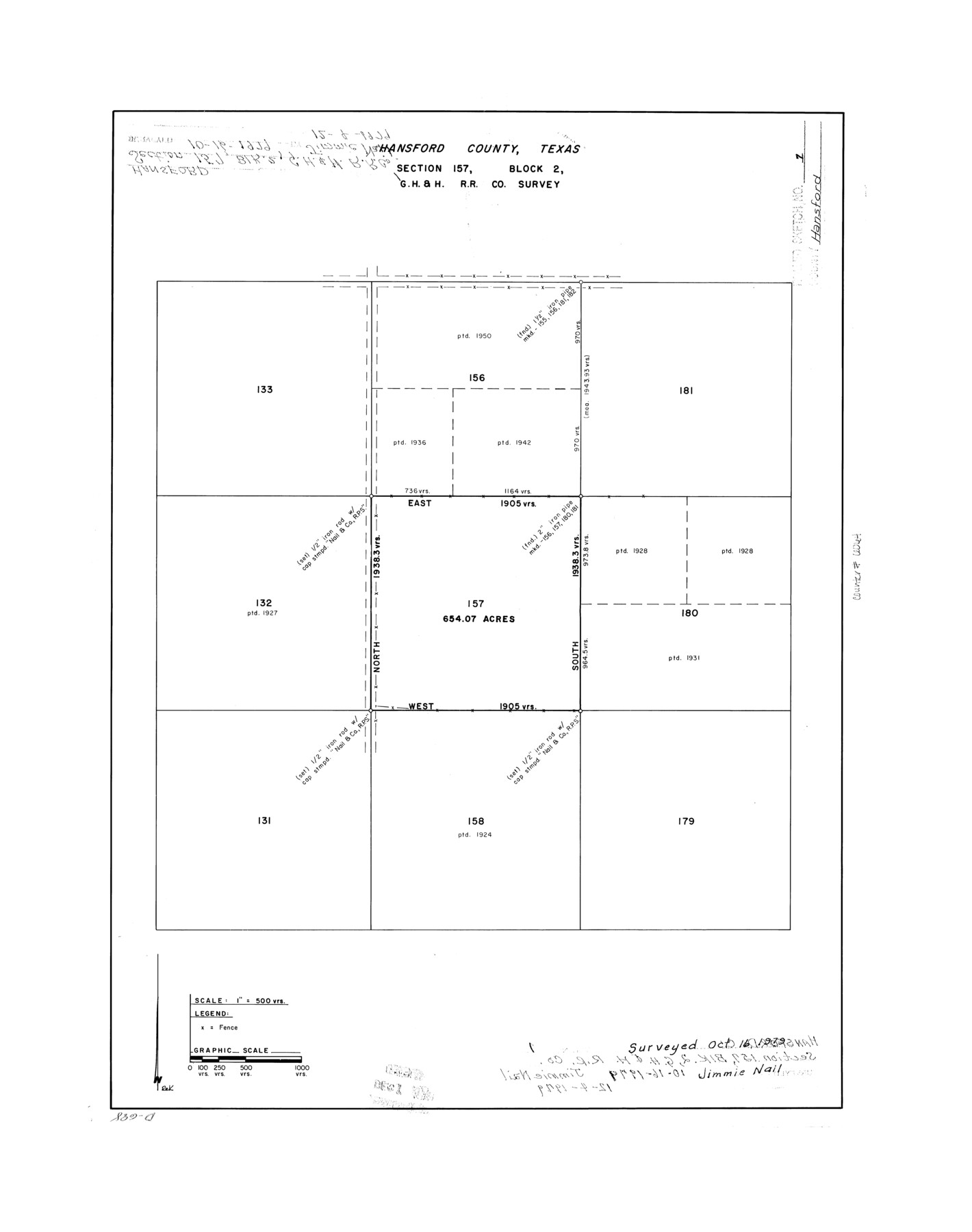
Hansford County Rolled Sketch 1
Hansford County, Texas section 157, Block 2, G. H. & H. R.R. Co. survey
-
Map/Doc
6064
-
Collection
General Map Collection
-
Object Dates
1979/10/16 (Creation Date)
1979/12/4 (File Date)
-
People and Organizations
Jimmie Nail (Surveyor/Engineer)
-
Counties
Hansford
-
Subjects
Surveying Rolled Sketch
-
Height x Width
22.3 x 17.6 inches
56.6 x 44.7 cm
-
Medium
mylar, print
-
Scale
1" = 500 varas
Part of: General Map Collection
Val Verde County Working Sketch 13

Print $20.00
- Digital $50.00
Val Verde County Working Sketch 13
1922
Size 24.8 x 25.3 inches
Map/Doc 72148
Flight Mission No. DCL-5C, Frame 30, Kenedy County

Print $20.00
- Digital $50.00
Flight Mission No. DCL-5C, Frame 30, Kenedy County
1943
Size 18.6 x 22.3 inches
Map/Doc 85842
Flight Mission No. DCL-7C, Frame 17, Kenedy County

Print $20.00
- Digital $50.00
Flight Mission No. DCL-7C, Frame 17, Kenedy County
1943
Size 15.3 x 15.2 inches
Map/Doc 86009
Jefferson County Working Sketch 35

Print $20.00
- Digital $50.00
Jefferson County Working Sketch 35
1982
Size 39.1 x 32.6 inches
Map/Doc 66579
[Surveys in the Bexar District along the San Antonio River showing the position of the missions]
![125, [Surveys in the Bexar District along the San Antonio River showing the position of the missions], General Map Collection](https://historictexasmaps.com/wmedia_w700/maps/125.tif.jpg)
Print $3.00
- Digital $50.00
[Surveys in the Bexar District along the San Antonio River showing the position of the missions]
1841
Size 11.2 x 16.0 inches
Map/Doc 125
Coleman County Sketch File 49

Print $80.00
- Digital $50.00
Coleman County Sketch File 49
1918
Size 14.2 x 8.6 inches
Map/Doc 18813
Real County Sketch File 12

Print $20.00
- Digital $50.00
Real County Sketch File 12
1932
Size 13.9 x 19.2 inches
Map/Doc 12231
Terrell County Rolled Sketch 34

Print $20.00
- Digital $50.00
Terrell County Rolled Sketch 34
1937
Size 29.3 x 25.3 inches
Map/Doc 7939
Wise County Rolled Sketch 6

Print $20.00
- Digital $50.00
Wise County Rolled Sketch 6
2000
Size 32.0 x 43.1 inches
Map/Doc 8280
Pecos County Sketch File 42

Print $30.00
- Digital $50.00
Pecos County Sketch File 42
1919
Size 9.1 x 8.0 inches
Map/Doc 33735
Smith County Rolled Sketch 6A1

Print $40.00
- Digital $50.00
Smith County Rolled Sketch 6A1
Size 49.2 x 38.6 inches
Map/Doc 10704
Trinity River, Sycamore Crossing Sheet/Denton Creek

Print $6.00
- Digital $50.00
Trinity River, Sycamore Crossing Sheet/Denton Creek
1928
Size 26.7 x 34.7 inches
Map/Doc 65224
You may also like
San Augustine County Working Sketch 2

Print $20.00
- Digital $50.00
San Augustine County Working Sketch 2
Size 28.5 x 19.1 inches
Map/Doc 63689
General Highway Map, Wharton County, Texas

Print $20.00
General Highway Map, Wharton County, Texas
1940
Size 18.5 x 24.9 inches
Map/Doc 79274
General Highway Map, Zapata County, Texas

Print $20.00
General Highway Map, Zapata County, Texas
1961
Size 18.2 x 24.8 inches
Map/Doc 79721
Vicinity of San Luis Pass, Galveston Island, Texas

Print $40.00
- Digital $50.00
Vicinity of San Luis Pass, Galveston Island, Texas
1933
Size 37.1 x 57.8 inches
Map/Doc 69943
Callahan County Working Sketch 12

Print $20.00
- Digital $50.00
Callahan County Working Sketch 12
1969
Size 25.6 x 38.5 inches
Map/Doc 67894
[Blocks CD, OP and GH in Crockett, Schleicher & Sutton Counties, Texas]
![75776, [Blocks CD, OP and GH in Crockett, Schleicher & Sutton Counties, Texas], Maddox Collection](https://historictexasmaps.com/wmedia_w700/maps/75776.tif.jpg)
Print $20.00
- Digital $50.00
[Blocks CD, OP and GH in Crockett, Schleicher & Sutton Counties, Texas]
Size 22.5 x 27.5 inches
Map/Doc 75776
Flight Mission No. CUG-3P, Frame 141, Kleberg County

Print $20.00
- Digital $50.00
Flight Mission No. CUG-3P, Frame 141, Kleberg County
1956
Size 18.4 x 22.2 inches
Map/Doc 86276
Hutchinson County Rolled Sketch 36

Print $20.00
- Digital $50.00
Hutchinson County Rolled Sketch 36
1888
Size 20.3 x 25.3 inches
Map/Doc 6293
General Highway Map, Garza County, Texas

Print $20.00
General Highway Map, Garza County, Texas
1961
Size 18.2 x 24.6 inches
Map/Doc 79478
Subdivision Map of Childress County School Land situated in Bailey and Cochran Counties, Tex.

Print $20.00
- Digital $50.00
Subdivision Map of Childress County School Land situated in Bailey and Cochran Counties, Tex.
Size 22.8 x 26.2 inches
Map/Doc 90200
[Surveys in the Bexar District along the Pedernales River]
![177, [Surveys in the Bexar District along the Pedernales River], General Map Collection](https://historictexasmaps.com/wmedia_w700/maps/177.tif.jpg)
Print $20.00
- Digital $50.00
[Surveys in the Bexar District along the Pedernales River]
1845
Size 18.7 x 11.0 inches
Map/Doc 177
Duval County Rolled Sketch 40

Print $20.00
- Digital $50.00
Duval County Rolled Sketch 40
1958
Size 22.8 x 31.1 inches
Map/Doc 5757