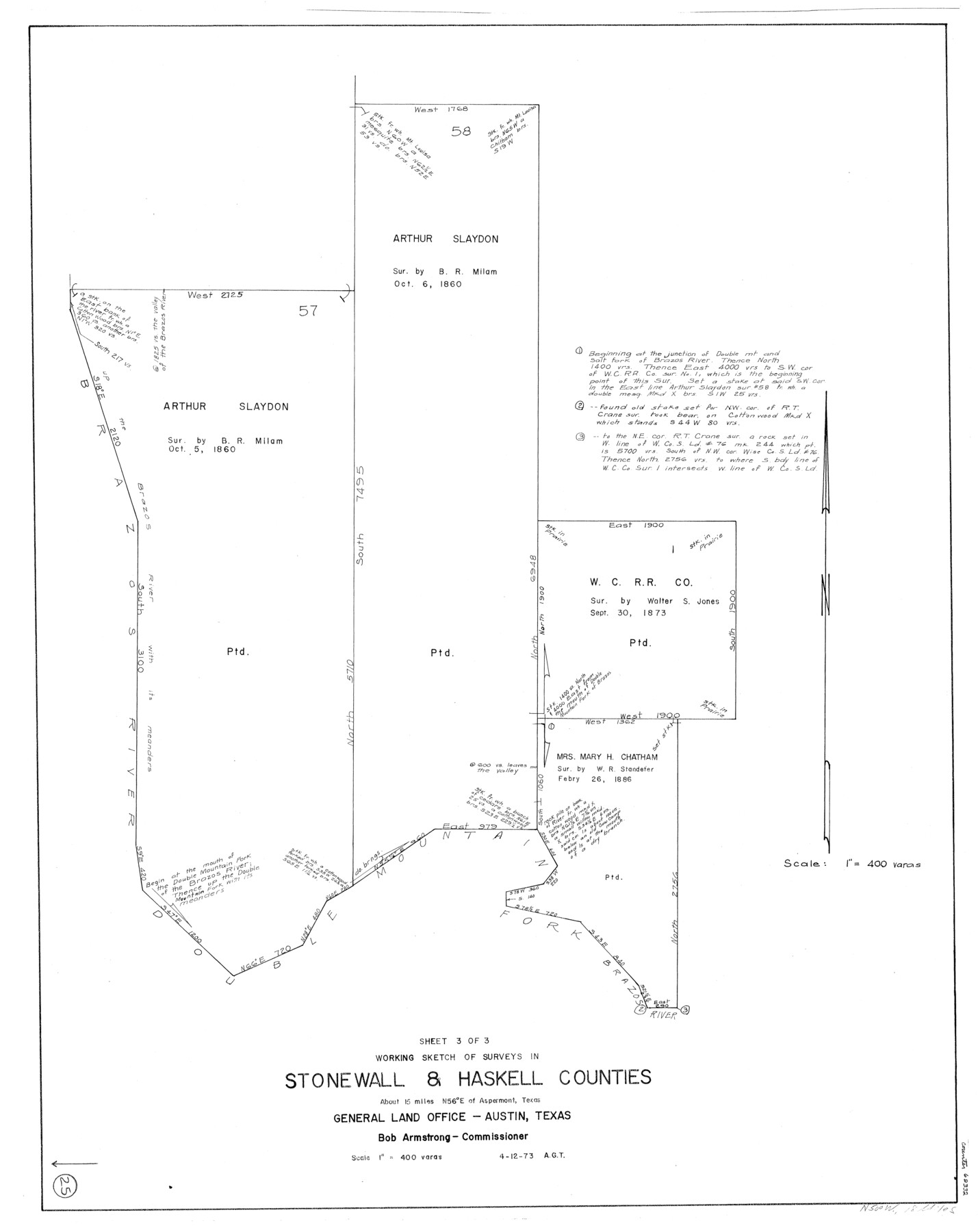
Stonewall County Working Sketch 25
-
Map/Doc
62332
-
Collection
General Map Collection
-
Object Dates
4/12/1973 (Creation Date)
-
People and Organizations
Abner G. Trigg (Draftsman)
-
Counties
Stonewall Haskell
-
Subjects
Surveying Working Sketch
-
Height x Width
29.5 x 23.4 inches
74.9 x 59.4 cm
-
Scale
1" = 400 varas
Part of: General Map Collection
Fort Bend County Working Sketch 27

Print $20.00
- Digital $50.00
Fort Bend County Working Sketch 27
1982
Size 17.2 x 19.2 inches
Map/Doc 69233
Grimes County Working Sketch 5

Print $40.00
- Digital $50.00
Grimes County Working Sketch 5
1949
Size 43.6 x 83.2 inches
Map/Doc 63296
Montague County

Print $20.00
- Digital $50.00
Montague County
1924
Size 47.0 x 34.2 inches
Map/Doc 66938
Matagorda County Working Sketch 16

Print $20.00
- Digital $50.00
Matagorda County Working Sketch 16
1960
Size 34.6 x 31.8 inches
Map/Doc 70874
Val Verde County Working Sketch 20

Print $20.00
- Digital $50.00
Val Verde County Working Sketch 20
1929
Size 30.5 x 20.2 inches
Map/Doc 72155
[Gulf Colorado & Santa Fe from 2178+36.0 to 3901+06.2]
![64697, [Gulf Colorado & Santa Fe from 2178+36.0 to 3901+06.2], General Map Collection](https://historictexasmaps.com/wmedia_w700/maps/64697-1.tif.jpg)
Print $40.00
- Digital $50.00
[Gulf Colorado & Santa Fe from 2178+36.0 to 3901+06.2]
Size 33.2 x 121.6 inches
Map/Doc 64697
Railroad Track Map, H&TCRRCo., Falls County, Texas

Print $4.00
- Digital $50.00
Railroad Track Map, H&TCRRCo., Falls County, Texas
1918
Size 11.5 x 18.4 inches
Map/Doc 62846
Medina County Sketch File 14

Print $24.00
- Digital $50.00
Medina County Sketch File 14
1914
Size 10.6 x 7.0 inches
Map/Doc 31471
Fractional Township No. 7 South Range No. 20 East of the Indian Meridian, Indian Territory

Print $20.00
- Digital $50.00
Fractional Township No. 7 South Range No. 20 East of the Indian Meridian, Indian Territory
1897
Size 19.2 x 24.2 inches
Map/Doc 75236
Jefferson County NRC Article 33.136 Sketch 9

Print $22.00
- Digital $50.00
Jefferson County NRC Article 33.136 Sketch 9
2011
Size 24.0 x 36.0 inches
Map/Doc 94517

Live Oak County Working Sketch 10

Print $20.00
- Digital $50.00
Live Oak County Working Sketch 10
1946
Size 36.2 x 41.8 inches
Map/Doc 70595
You may also like
Flight Mission No. BRA-16M, Frame 112, Jefferson County

Print $20.00
- Digital $50.00
Flight Mission No. BRA-16M, Frame 112, Jefferson County
1953
Size 18.6 x 22.2 inches
Map/Doc 85722
E. N. Gustafson's survey of Southern Portion of Lake Austin, Matagorda Co., TX

Print $20.00
- Digital $50.00
E. N. Gustafson's survey of Southern Portion of Lake Austin, Matagorda Co., TX
1926
Size 36.7 x 42.7 inches
Map/Doc 2922
Austin County Sketch File 13

Print $40.00
- Digital $50.00
Austin County Sketch File 13
Size 13.9 x 13.2 inches
Map/Doc 10877
Ward County Working Sketch 23

Print $40.00
- Digital $50.00
Ward County Working Sketch 23
1953
Size 29.1 x 59.5 inches
Map/Doc 72329
Travis County Sketch File 4

Print $9.00
- Digital $50.00
Travis County Sketch File 4
1853
Size 13.1 x 8.2 inches
Map/Doc 38275
Matagorda Light to Aransas Pass

Print $20.00
- Digital $50.00
Matagorda Light to Aransas Pass
1946
Size 35.8 x 44.5 inches
Map/Doc 73394
Nacogdoches County Working Sketch 2

Print $20.00
- Digital $50.00
Nacogdoches County Working Sketch 2
1904
Size 20.5 x 24.1 inches
Map/Doc 71218
Shackelford County Working Sketch 13

Print $20.00
- Digital $50.00
Shackelford County Working Sketch 13
1999
Size 18.6 x 16.2 inches
Map/Doc 63853
Reagan County Sketch File 13

Print $40.00
- Digital $50.00
Reagan County Sketch File 13
1931
Size 15.6 x 15.1 inches
Map/Doc 34991
Leon County Rolled Sketch 32

Print $20.00
- Digital $50.00
Leon County Rolled Sketch 32
Size 34.2 x 40.7 inches
Map/Doc 6616
Red River County Sketch File 8b

Print $6.00
- Digital $50.00
Red River County Sketch File 8b
1860
Size 8.2 x 3.7 inches
Map/Doc 35114
Menard County Working Sketch 10

Print $20.00
- Digital $50.00
Menard County Working Sketch 10
1938
Size 21.8 x 18.5 inches
Map/Doc 70957