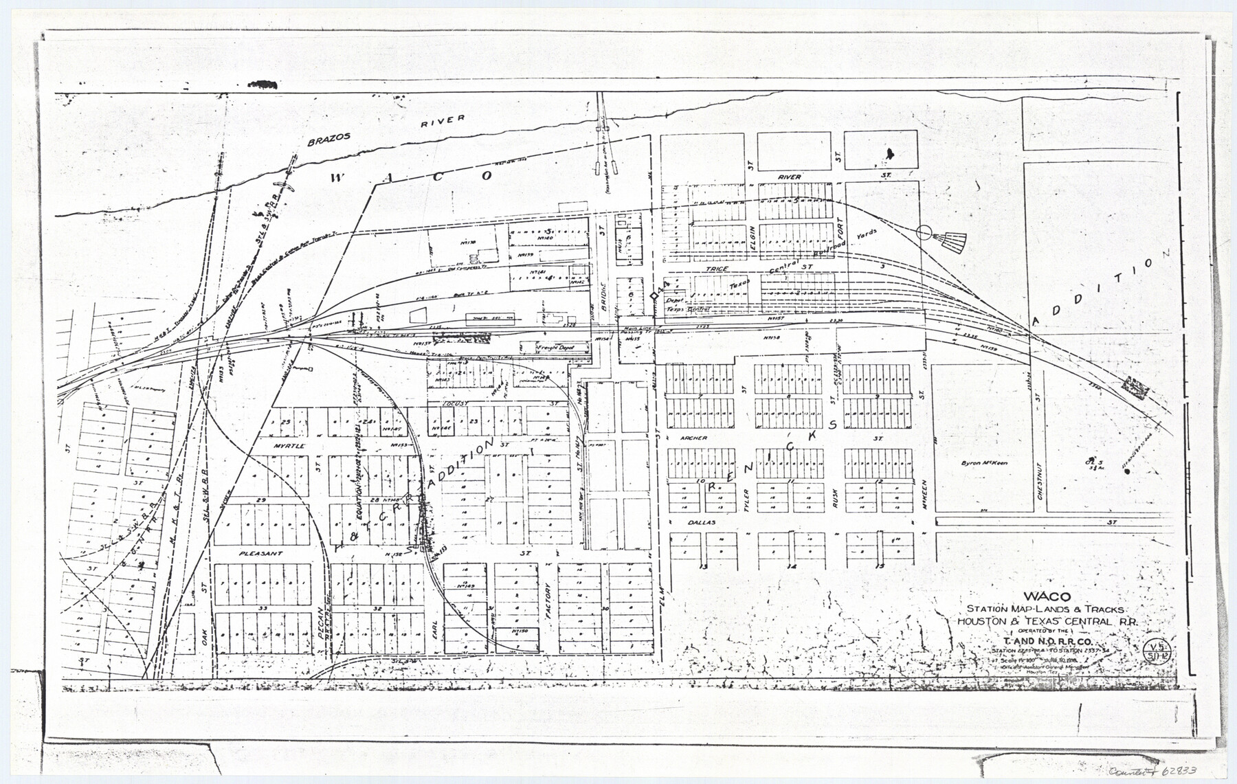
Railroad Track Map, H&TCRRCo., Falls County, Texas
Right of Way and Track Map
K-7-79 flat folder
-
Map/Doc
62833
-
Collection
General Map Collection
-
Object Dates
1918 (Creation Date)
-
Counties
Falls
-
Subjects
Railroads
-
Height x Width
11.7 x 18.5 inches
29.7 x 47.0 cm
-
Comments
Operated by the Texas and New Orleans Railroad Company, Waco Branch.
Part of: General Map Collection
Johnson County Working Sketch 22

Print $20.00
- Digital $50.00
Johnson County Working Sketch 22
1992
Size 14.6 x 18.1 inches
Map/Doc 66635
Flight Mission No. DQN-2K, Frame 160, Calhoun County

Print $20.00
- Digital $50.00
Flight Mission No. DQN-2K, Frame 160, Calhoun County
1953
Size 18.6 x 22.3 inches
Map/Doc 84322
Jones County Working Sketch 3

Print $20.00
- Digital $50.00
Jones County Working Sketch 3
1938
Size 28.7 x 25.4 inches
Map/Doc 66641
Right of Way and Track Map, Houston & Texas Central R.R. operated by the T. and N. O. R.R., Fort Worth Branch

Print $40.00
- Digital $50.00
Right of Way and Track Map, Houston & Texas Central R.R. operated by the T. and N. O. R.R., Fort Worth Branch
1918
Size 31.9 x 57.7 inches
Map/Doc 64779
Hudspeth County Sketch File 42

Print $12.00
- Digital $50.00
Hudspeth County Sketch File 42
1982
Size 14.2 x 8.7 inches
Map/Doc 27016
St. L. S.-W. Ry. of Texas, Map of Lufkin Branch in Smith County, Texas

Print $40.00
- Digital $50.00
St. L. S.-W. Ry. of Texas, Map of Lufkin Branch in Smith County, Texas
1912
Size 24.3 x 122.9 inches
Map/Doc 64692
Trinity River, Oliver Crossing Sheet/Chambers Creek

Print $6.00
- Digital $50.00
Trinity River, Oliver Crossing Sheet/Chambers Creek
1931
Size 30.1 x 28.2 inches
Map/Doc 65231
El Paso County Sketch File 42

Print $16.00
- Digital $50.00
El Paso County Sketch File 42
1996
Size 14.3 x 8.9 inches
Map/Doc 22241
Brewster County Rolled Sketch 114

Print $20.00
- Digital $50.00
Brewster County Rolled Sketch 114
1964
Size 17.3 x 11.4 inches
Map/Doc 5292
Fractional Township No. 8 South Range No. 13 East of the Indian Meridian, Indian Territory

Print $20.00
- Digital $50.00
Fractional Township No. 8 South Range No. 13 East of the Indian Meridian, Indian Territory
1896
Size 19.1 x 24.3 inches
Map/Doc 75224
Galveston County Sketch File 61a

Print $12.00
- Digital $50.00
Galveston County Sketch File 61a
1988
Size 11.2 x 8.8 inches
Map/Doc 23665
Flight Mission No. DIX-5P, Frame 106, Aransas County

Print $20.00
- Digital $50.00
Flight Mission No. DIX-5P, Frame 106, Aransas County
1956
Size 17.8 x 18.0 inches
Map/Doc 83784
You may also like
Chambers County NRC Article 33.136 Sketch 2

Print $2.00
- Digital $50.00
Chambers County NRC Article 33.136 Sketch 2
2004
Size 8.2 x 10.8 inches
Map/Doc 82998
Flight Mission No. BQR-22K, Frame 35, Brazoria County

Print $20.00
- Digital $50.00
Flight Mission No. BQR-22K, Frame 35, Brazoria County
1953
Size 18.7 x 22.5 inches
Map/Doc 84119
Baylor County Working Sketch 8

Print $20.00
- Digital $50.00
Baylor County Working Sketch 8
1955
Size 44.1 x 20.7 inches
Map/Doc 67293
Runnels County

Print $20.00
- Digital $50.00
Runnels County
1898
Size 43.3 x 36.9 inches
Map/Doc 63009
Chambers County Sketch File 23

Print $2.00
- Digital $50.00
Chambers County Sketch File 23
1878
Size 10.0 x 7.9 inches
Map/Doc 17597
Rusk County Working Sketch 37b

Print $40.00
- Digital $50.00
Rusk County Working Sketch 37b
2007
Size 50.0 x 31.0 inches
Map/Doc 87497
Flight Mission No. CLL-1N, Frame 79, Willacy County

Print $20.00
- Digital $50.00
Flight Mission No. CLL-1N, Frame 79, Willacy County
1954
Size 18.6 x 22.2 inches
Map/Doc 87025
Hemphill County Rolled Sketch 17

Print $20.00
- Digital $50.00
Hemphill County Rolled Sketch 17
1965
Size 23.5 x 39.9 inches
Map/Doc 6199
Montgomery County Working Sketch 30

Print $20.00
- Digital $50.00
Montgomery County Working Sketch 30
1946
Size 30.7 x 34.8 inches
Map/Doc 71137
[Surveys along the Bosque River]
![236, [Surveys along the Bosque River], General Map Collection](https://historictexasmaps.com/wmedia_w700/maps/236.tif.jpg)
Print $3.00
- Digital $50.00
[Surveys along the Bosque River]
1846
Size 9.4 x 12.8 inches
Map/Doc 236
Sabine Pass and mouth of the River Sabine in the sea

Print $20.00
- Digital $50.00
Sabine Pass and mouth of the River Sabine in the sea
1842
Size 24.0 x 19.1 inches
Map/Doc 93766
Map of McMullen County

Print $20.00
- Digital $50.00
Map of McMullen County
1887
Size 26.8 x 18.6 inches
Map/Doc 3866