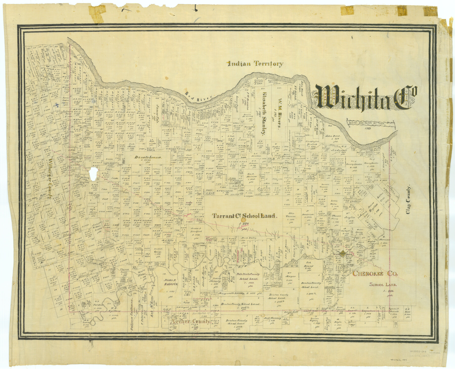
Wichita Co.
-
Map/Doc
63122
-
Collection
General Map Collection
-
Object Dates
1889 (Creation Date)
-
People and Organizations
Texas General Land Office (Publisher)
-
Counties
Wichita
-
Subjects
County
-
Height x Width
33.0 x 40.7 inches
83.8 x 103.4 cm
Part of: General Map Collection
Coryell County Sketch File 9

Print $4.00
- Digital $50.00
Coryell County Sketch File 9
1858
Size 7.2 x 8.2 inches
Map/Doc 19359
[Map of] North America
![88884, [Map of] North America, General Map Collection](https://historictexasmaps.com/wmedia_w700/maps/88884.tif.jpg)
Print $3.00
- Digital $50.00
[Map of] North America
1834
Size 11.0 x 8.5 inches
Map/Doc 88884
Harris County Sketch File 80a

Print $20.00
- Digital $50.00
Harris County Sketch File 80a
1892
Size 27.8 x 17.6 inches
Map/Doc 11667
Red River County Working Sketch 82

Print $20.00
- Digital $50.00
Red River County Working Sketch 82
1996
Size 21.9 x 30.6 inches
Map/Doc 72068
Tom Green County Working Sketch 7

Print $20.00
- Digital $50.00
Tom Green County Working Sketch 7
1949
Size 32.2 x 31.7 inches
Map/Doc 69376
[Atlas A, Table of Contents, part 1]
![78351, [Atlas A, Table of Contents, part 1], General Map Collection](https://historictexasmaps.com/wmedia_w700/maps/78351.tif.jpg)
Print $20.00
- Digital $50.00
[Atlas A, Table of Contents, part 1]
Size 14.5 x 15.0 inches
Map/Doc 78351
Hutchinson County Rolled Sketch 44-14

Print $20.00
- Digital $50.00
Hutchinson County Rolled Sketch 44-14
2002
Size 24.0 x 36.0 inches
Map/Doc 77550
Hutchinson County Sketch File 4a

Print $7.00
- Digital $50.00
Hutchinson County Sketch File 4a
Size 25.9 x 43.8 inches
Map/Doc 10625
Morris County Rolled Sketch 2A

Print $20.00
- Digital $50.00
Morris County Rolled Sketch 2A
Size 24.0 x 18.7 inches
Map/Doc 10281
Upshur County Sketch File 7

Print $4.00
- Digital $50.00
Upshur County Sketch File 7
1849
Size 8.2 x 10.2 inches
Map/Doc 38744
Hood County Working Sketch 8

Print $20.00
- Digital $50.00
Hood County Working Sketch 8
1971
Size 30.1 x 37.8 inches
Map/Doc 66202
Harris County Working Sketch 109

Print $20.00
- Digital $50.00
Harris County Working Sketch 109
1981
Size 21.4 x 27.2 inches
Map/Doc 66001
You may also like
Plat Town of Swearingen, Cottle Co., Texas

Print $20.00
- Digital $50.00
Plat Town of Swearingen, Cottle Co., Texas
1918
Size 39.8 x 30.6 inches
Map/Doc 513
Crane County Sketch File 20

Print $4.00
- Digital $50.00
Crane County Sketch File 20
1928
Size 14.4 x 9.0 inches
Map/Doc 19588
Flight Mission No. DAG-16K, Frame 74, Matagorda County

Print $20.00
- Digital $50.00
Flight Mission No. DAG-16K, Frame 74, Matagorda County
1952
Size 18.6 x 22.3 inches
Map/Doc 86320
[Map of T&P Blocks 1 and 2 in Jeff Davis and Presidio Counties]
![88959, [Map of T&P Blocks 1 and 2 in Jeff Davis and Presidio Counties], Library of Congress](https://historictexasmaps.com/wmedia_w700/maps/88959.tif.jpg)
Print $20.00
[Map of T&P Blocks 1 and 2 in Jeff Davis and Presidio Counties]
Size 22.2 x 17.3 inches
Map/Doc 88959
Erath County Rolled Sketch 2

Print $20.00
- Digital $50.00
Erath County Rolled Sketch 2
Size 21.0 x 25.9 inches
Map/Doc 5861
Guadalupe County

Print $20.00
- Digital $50.00
Guadalupe County
1977
Size 36.5 x 47.8 inches
Map/Doc 95515
Maverick County Sketch File 9

Print $8.00
- Digital $50.00
Maverick County Sketch File 9
1878
Size 5.3 x 5.6 inches
Map/Doc 31068
Fort Bend County Sketch File 28

Print $40.00
- Digital $50.00
Fort Bend County Sketch File 28
Size 13.7 x 8.6 inches
Map/Doc 22979
Blanco County Working Sketch 6b

Print $40.00
- Digital $50.00
Blanco County Working Sketch 6b
1930
Size 52.6 x 27.8 inches
Map/Doc 67366
Val Verde County Working Sketch 80

Print $20.00
- Digital $50.00
Val Verde County Working Sketch 80
1973
Size 29.1 x 46.1 inches
Map/Doc 72215
Flight Mission No. DQN-6K, Frame 8, Calhoun County

Print $20.00
- Digital $50.00
Flight Mission No. DQN-6K, Frame 8, Calhoun County
1953
Size 18.5 x 22.1 inches
Map/Doc 84430
Red River County Working Sketch 80

Print $20.00
- Digital $50.00
Red River County Working Sketch 80
1982
Size 24.1 x 29.3 inches
Map/Doc 72063