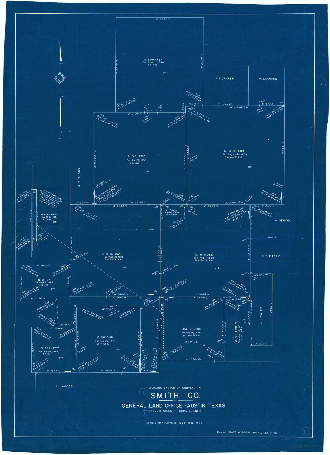
Smith County Working Sketch 10
-
Map/Doc
63895
-
Collection
General Map Collection
-
Object Dates
8/5/1952 (Creation Date)
-
People and Organizations
Otto G. Kurio (Draftsman)
-
Counties
Smith
-
Subjects
Surveying Working Sketch
-
Height x Width
33.4 x 24.2 inches
84.8 x 61.5 cm
-
Scale
1" = 400 varas
Part of: General Map Collection
Johnson County

Print $20.00
- Digital $50.00
Johnson County
1943
Size 39.8 x 37.0 inches
Map/Doc 77332
Polk County Sketch File 37

Print $18.00
- Digital $50.00
Polk County Sketch File 37
1901
Size 9.1 x 8.1 inches
Map/Doc 34259
[Sketch for Mineral Application 26501 - Sabine River, T. A. Oldhausen]
![2832, [Sketch for Mineral Application 26501 - Sabine River, T. A. Oldhausen], General Map Collection](https://historictexasmaps.com/wmedia_w700/maps/2832.tif.jpg)
Print $20.00
- Digital $50.00
[Sketch for Mineral Application 26501 - Sabine River, T. A. Oldhausen]
1931
Size 24.0 x 36.0 inches
Map/Doc 2832
Haskell County Sketch File 15

Print $24.00
- Digital $50.00
Haskell County Sketch File 15
1893
Size 13.5 x 16.5 inches
Map/Doc 26158
Map of Williamson County

Print $20.00
- Digital $50.00
Map of Williamson County
1876
Size 21.2 x 28.6 inches
Map/Doc 4152
No. 1 - Survey for a road from the Brazo Santiago to the Rio Grande

Print $20.00
- Digital $50.00
No. 1 - Survey for a road from the Brazo Santiago to the Rio Grande
1847
Size 18.3 x 27.1 inches
Map/Doc 72876

Cherokee County Working Sketch 13

Print $20.00
- Digital $50.00
Cherokee County Working Sketch 13
1957
Size 46.5 x 43.8 inches
Map/Doc 67968
Map of the Passo Cavallo

Print $20.00
- Digital $50.00
Map of the Passo Cavallo
1853
Size 18.0 x 27.0 inches
Map/Doc 73011
Cass County Working Sketch 11

Print $3.00
- Digital $50.00
Cass County Working Sketch 11
Size 14.8 x 10.3 inches
Map/Doc 67914
Map of Texas and Pacific Ry. Company's Surveys in the 80 Mile Reserve

Print $40.00
- Digital $50.00
Map of Texas and Pacific Ry. Company's Surveys in the 80 Mile Reserve
1885
Size 41.5 x 91.8 inches
Map/Doc 60313
Maps of Gulf Intracoastal Waterway, Texas - Sabine River to the Rio Grande and connecting waterways including ship channels

Print $20.00
- Digital $50.00
Maps of Gulf Intracoastal Waterway, Texas - Sabine River to the Rio Grande and connecting waterways including ship channels
1966
Size 14.5 x 22.2 inches
Map/Doc 61928
You may also like
King County Working Sketch 18-0

Print $40.00
- Digital $50.00
King County Working Sketch 18-0
Size 44.0 x 56.5 inches
Map/Doc 78212
Henderson County Sketch File 16

Print $40.00
- Digital $50.00
Henderson County Sketch File 16
1935
Size 14.9 x 16.3 inches
Map/Doc 26359
Terry County Working Sketch 4

Print $20.00
- Digital $50.00
Terry County Working Sketch 4
Size 24.9 x 29.6 inches
Map/Doc 62109
Flight Mission No. DQO-3K, Frame 20, Galveston County

Print $20.00
- Digital $50.00
Flight Mission No. DQO-3K, Frame 20, Galveston County
1952
Size 18.8 x 22.6 inches
Map/Doc 85061
Township No. 6 South Range No. 8 West of the Indian Meridian

Print $20.00
- Digital $50.00
Township No. 6 South Range No. 8 West of the Indian Meridian
1874
Size 19.2 x 24.4 inches
Map/Doc 75155
Crockett County Sketch File 4a

Print $20.00
- Digital $50.00
Crockett County Sketch File 4a
Size 28.1 x 8.2 inches
Map/Doc 11215
Duval County Sketch File 67

Print $16.00
- Digital $50.00
Duval County Sketch File 67
1949
Size 14.2 x 8.8 inches
Map/Doc 21448
Flight Mission No. DAG-22K, Frame 84, Matagorda County

Print $20.00
- Digital $50.00
Flight Mission No. DAG-22K, Frame 84, Matagorda County
1953
Size 15.7 x 15.6 inches
Map/Doc 86468
Sketch Showing Survey of Sec. 2 Public School Lands Block B-16, Ector County, Texas

Print $20.00
- Digital $50.00
Sketch Showing Survey of Sec. 2 Public School Lands Block B-16, Ector County, Texas
1930
Size 39.6 x 20.9 inches
Map/Doc 90924
Jim Wells Co.

Print $20.00
- Digital $50.00
Jim Wells Co.
1913
Size 43.7 x 22.1 inches
Map/Doc 16861

Anderson County Sketch File 17

Print $4.00
- Digital $50.00
Anderson County Sketch File 17
1871
Size 10.2 x 7.7 inches
Map/Doc 12789