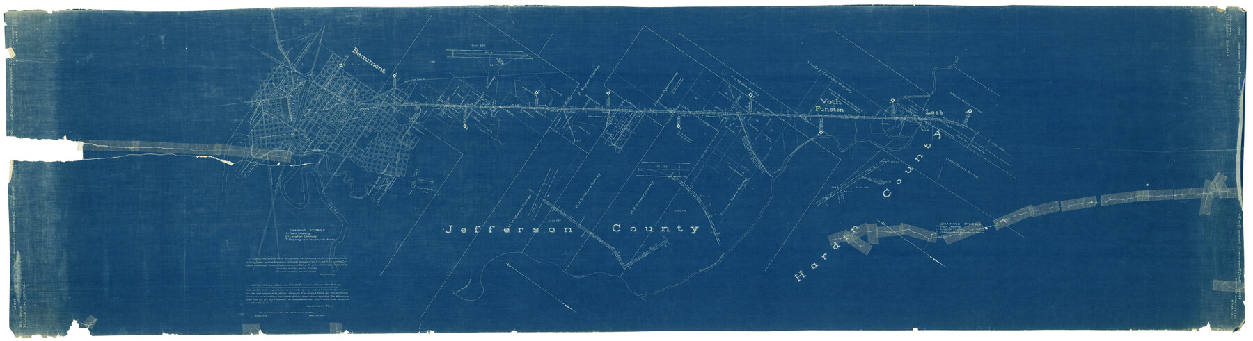
Gulf, Beaumont & Kansas City Railway
Z-2-115
-
Map/Doc
64435
-
Collection
General Map Collection
-
Object Dates
1909 (Creation Date)
-
Counties
Hardin Jefferson
-
Subjects
Railroads
-
Height x Width
25.1 x 92.5 inches
63.8 x 235.0 cm
-
Medium
blueprint/diazo
-
Comments
Help Save Texas History - Adopt Me!
-
Features
GB&KC
Beaumont
G&IS
T&NO
KCS
Neches River
Brakes Bayou
Colder Avenue
Fenman Street
Collier Ferry Road
S&ET
Pine Island Creek
Voth
Funston
North to Silsbee
Loeb
Part of: General Map Collection
Uvalde County Sketch File 14

Print $6.00
- Digital $50.00
Uvalde County Sketch File 14
1849
Size 8.5 x 11.0 inches
Map/Doc 12529
East Part of Edwards County

Print $40.00
- Digital $50.00
East Part of Edwards County
1975
Size 55.7 x 40.5 inches
Map/Doc 73138
Lee County Rolled Sketch 1

Print $40.00
- Digital $50.00
Lee County Rolled Sketch 1
1939
Size 71.0 x 42.4 inches
Map/Doc 10739
Montgomery County Rolled Sketch 38

Print $40.00
- Digital $50.00
Montgomery County Rolled Sketch 38
1962
Size 56.0 x 30.8 inches
Map/Doc 9545
Flight Mission No. BRE-4P, Frame 168, Nueces County

Print $20.00
- Digital $50.00
Flight Mission No. BRE-4P, Frame 168, Nueces County
1956
Size 18.7 x 22.6 inches
Map/Doc 86831
Wilbarger County Sketch File 3

Print $26.00
- Digital $50.00
Wilbarger County Sketch File 3
Size 7.4 x 13.9 inches
Map/Doc 40166
[Right of Way & Track Map, The Texas & Pacific Ry. Co. Main Line]
![64691, [Right of Way & Track Map, The Texas & Pacific Ry. Co. Main Line], General Map Collection](https://historictexasmaps.com/wmedia_w700/maps/64691.tif.jpg)
Print $20.00
- Digital $50.00
[Right of Way & Track Map, The Texas & Pacific Ry. Co. Main Line]
Size 10.9 x 18.6 inches
Map/Doc 64691
Parker County Sketch File 22

Print $4.00
- Digital $50.00
Parker County Sketch File 22
Size 8.7 x 6.3 inches
Map/Doc 33562
Cooke County Rolled Sketch 4

Print $20.00
- Digital $50.00
Cooke County Rolled Sketch 4
Size 18.1 x 23.1 inches
Map/Doc 5562
Runnels County Working Sketch 2

Print $20.00
- Digital $50.00
Runnels County Working Sketch 2
Size 19.8 x 29.4 inches
Map/Doc 63598
Harris County Rolled Sketch J

Print $40.00
- Digital $50.00
Harris County Rolled Sketch J
1933
Size 53.6 x 41.6 inches
Map/Doc 9122
Pecos County Sketch File 35

Print $4.00
- Digital $50.00
Pecos County Sketch File 35
Size 8.9 x 15.3 inches
Map/Doc 33716
You may also like
Sulphur River and Cuthand Creek, Hardison Lake Sheet

Print $20.00
- Digital $50.00
Sulphur River and Cuthand Creek, Hardison Lake Sheet
1919
Size 13.4 x 18.0 inches
Map/Doc 78327
Stonewall County Sketch File 19

Print $20.00
- Digital $50.00
Stonewall County Sketch File 19
Size 33.2 x 33.6 inches
Map/Doc 10392
Bee County Working Sketch Graphic Index

Print $20.00
- Digital $50.00
Bee County Working Sketch Graphic Index
1950
Size 41.6 x 45.4 inches
Map/Doc 76464
Harris County Sketch File 9

Print $4.00
- Digital $50.00
Harris County Sketch File 9
1861
Size 6.7 x 7.3 inches
Map/Doc 25340
Terrell County Working Sketch 52

Print $40.00
- Digital $50.00
Terrell County Working Sketch 52
1958
Size 49.2 x 42.5 inches
Map/Doc 62145
Reeves County Working Sketch 15

Print $40.00
- Digital $50.00
Reeves County Working Sketch 15
1961
Size 43.0 x 53.1 inches
Map/Doc 63458
Brewster County Rolled Sketch 29

Print $20.00
- Digital $50.00
Brewster County Rolled Sketch 29
1910
Size 17.5 x 18.5 inches
Map/Doc 5216
San Patricio County Rolled Sketch 42

Print $20.00
- Digital $50.00
San Patricio County Rolled Sketch 42
Size 18.6 x 37.3 inches
Map/Doc 7728
Current Miscellaneous File 10

Print $8.00
- Digital $50.00
Current Miscellaneous File 10
1916
Size 11.4 x 8.8 inches
Map/Doc 73774
Harris County Boundary File 39a

Print $12.00
- Digital $50.00
Harris County Boundary File 39a
Size 10.1 x 8.0 inches
Map/Doc 54329
Mosaic composed of aerial photographs - Texas City, Tex.

Print $20.00
- Digital $50.00
Mosaic composed of aerial photographs - Texas City, Tex.
1923
Size 15.0 x 16.8 inches
Map/Doc 97166
[J. Poitevent Blocks 1 and 2, T. & P. Blocks 31-36, Townships 3N-5N and other Blocks in vicinity]
![93195, [J. Poitevent Blocks 1 and 2, T. & P. Blocks 31-36, Townships 3N-5N and other Blocks in vicinity], Twichell Survey Records](https://historictexasmaps.com/wmedia_w700/maps/93195-1.tif.jpg)
Print $40.00
- Digital $50.00
[J. Poitevent Blocks 1 and 2, T. & P. Blocks 31-36, Townships 3N-5N and other Blocks in vicinity]
Size 50.0 x 50.1 inches
Map/Doc 93195