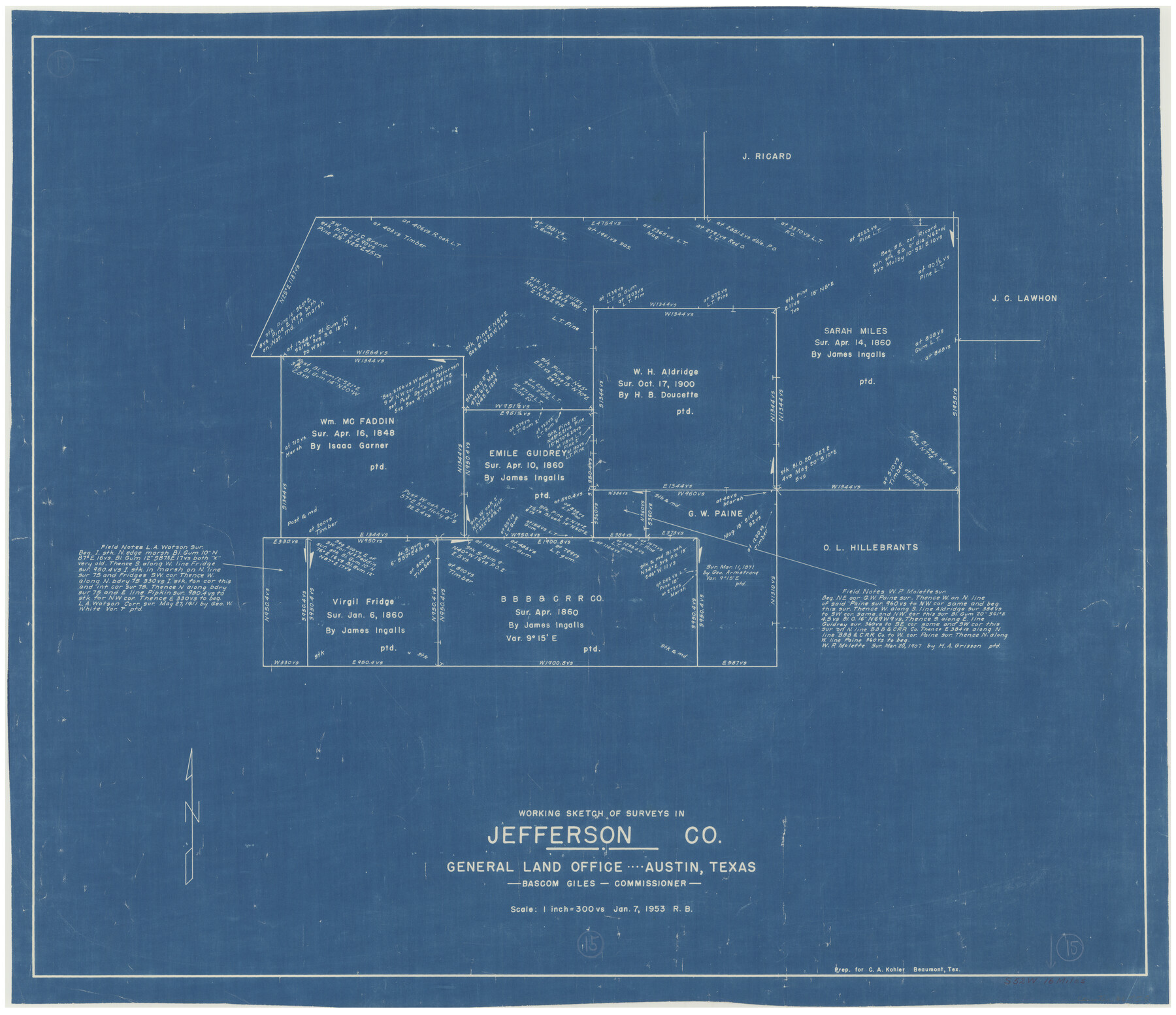
Jefferson County Working Sketch 15
-
Map/Doc
66558
-
Collection
General Map Collection
-
Object Dates
1/7/1953 (Creation Date)
-
People and Organizations
Roy Buckholts (Draftsman)
-
Counties
Jefferson
-
Subjects
Surveying Working Sketch
-
Height x Width
24.5 x 28.6 inches
62.2 x 72.6 cm
-
Scale
1" = 300 varas
Part of: General Map Collection
[Sketch for Mineral Application 27670 - Strip between Simon Sanchez leagues and Trinity River]
![65646, [Sketch for Mineral Application 27670 - Strip between Simon Sanchez leagues and Trinity River], General Map Collection](https://historictexasmaps.com/wmedia_w700/maps/65646.tif.jpg)
Print $40.00
- Digital $50.00
[Sketch for Mineral Application 27670 - Strip between Simon Sanchez leagues and Trinity River]
Size 55.5 x 17.8 inches
Map/Doc 65646
Schleicher County Working Sketch 14

Print $20.00
- Digital $50.00
Schleicher County Working Sketch 14
1928
Size 32.6 x 22.4 inches
Map/Doc 63816
Kleberg County Rolled Sketch 10

Print $20.00
- Digital $50.00
Kleberg County Rolled Sketch 10
1952
Size 42.8 x 37.3 inches
Map/Doc 9397
Jefferson County Working Sketch 42

Print $20.00
- Digital $50.00
Jefferson County Working Sketch 42
1996
Size 31.7 x 47.2 inches
Map/Doc 66586
Duval County Sketch File 35

Print $24.00
- Digital $50.00
Duval County Sketch File 35
Size 14.4 x 8.8 inches
Map/Doc 21359
Webb County Rolled Sketch EF5

Print $20.00
- Digital $50.00
Webb County Rolled Sketch EF5
1931
Size 41.4 x 32.0 inches
Map/Doc 8227
El Paso County Sketch File 19

Print $30.00
- Digital $50.00
El Paso County Sketch File 19
1905
Size 13.3 x 8.7 inches
Map/Doc 22009
University Land in Grayson County in Two Parts

Print $20.00
- Digital $50.00
University Land in Grayson County in Two Parts
Size 30.6 x 25.8 inches
Map/Doc 62965
Pecos County Sketch File 29a

Print $20.00
- Digital $50.00
Pecos County Sketch File 29a
Size 24.5 x 31.0 inches
Map/Doc 12171
Culberson County Rolled Sketch 18

Print $6.00
- Digital $50.00
Culberson County Rolled Sketch 18
1911
Size 24.1 x 34.5 inches
Map/Doc 5650
Pecos County Sketch File 31

Print $20.00
- Digital $50.00
Pecos County Sketch File 31
1931
Size 14.3 x 32.4 inches
Map/Doc 12173
Flight Mission No. DAG-24K, Frame 128, Matagorda County

Print $20.00
- Digital $50.00
Flight Mission No. DAG-24K, Frame 128, Matagorda County
1953
Size 17.2 x 22.5 inches
Map/Doc 86546
You may also like
Crockett County Sketch File 29

Print $8.00
- Digital $50.00
Crockett County Sketch File 29
1883
Size 12.5 x 8.1 inches
Map/Doc 19727
King County Working Sketch 5

Print $20.00
- Digital $50.00
King County Working Sketch 5
1943
Size 19.2 x 22.0 inches
Map/Doc 70169
Upton County Sketch File 4

Print $40.00
- Digital $50.00
Upton County Sketch File 4
1886
Size 19.5 x 9.0 inches
Map/Doc 12510

Zapata County Working Sketch 5

Print $20.00
- Digital $50.00
Zapata County Working Sketch 5
1940
Size 23.4 x 18.3 inches
Map/Doc 62056
Zapata County Rolled Sketch 26

Print $20.00
- Digital $50.00
Zapata County Rolled Sketch 26
1982
Size 43.0 x 30.7 inches
Map/Doc 8319

Lubbock County Sketch File 11

Print $20.00
- Digital $50.00
Lubbock County Sketch File 11
1914
Size 19.4 x 18.5 inches
Map/Doc 4585
Montgomery County Rolled Sketch 12

Print $20.00
- Digital $50.00
Montgomery County Rolled Sketch 12
Size 23.4 x 30.5 inches
Map/Doc 6801

Travis County Sketch File 28

Print $40.00
- Digital $50.00
Travis County Sketch File 28
Size 17.5 x 12.2 inches
Map/Doc 38341
Hutson Addition to Umbarger, sec. 76, Blk. B-5, Randall Co., Texas

Print $20.00
- Digital $50.00
Hutson Addition to Umbarger, sec. 76, Blk. B-5, Randall Co., Texas
Size 32.0 x 31.4 inches
Map/Doc 92154