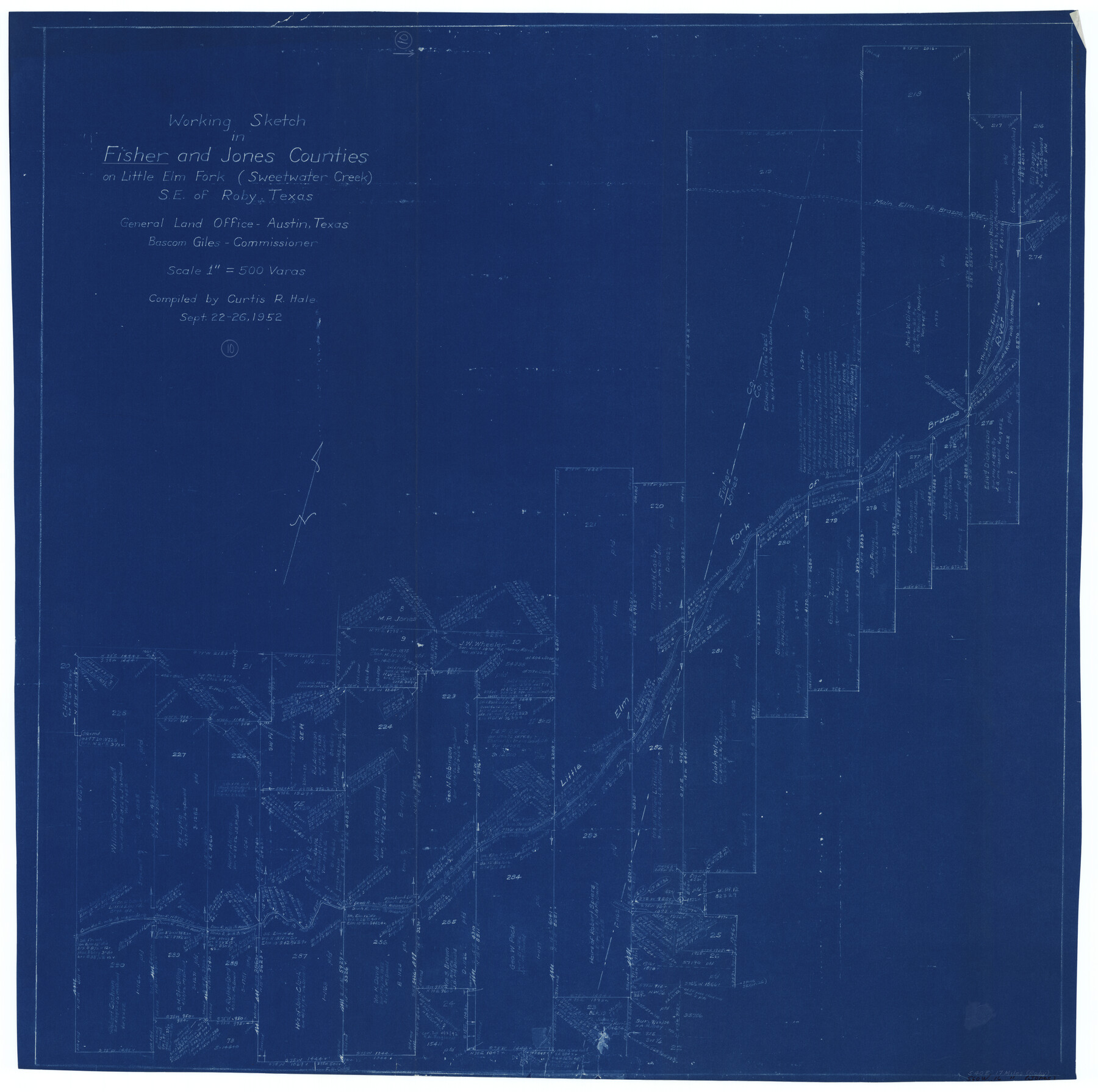
Fisher County Working Sketch 10
-
Map/Doc
69144
-
Collection
General Map Collection
-
Object Dates
9/22-26/1952 (Creation Date)
-
People and Organizations
Curtis R. Hale (Draftsman)
-
Counties
Fisher Jones
-
Subjects
Surveying Working Sketch
-
Height x Width
40.5 x 40.7 inches
102.9 x 103.4 cm
-
Scale
1" = 500 varas
Part of: General Map Collection
Pecos County Working Sketch 127

Print $40.00
- Digital $50.00
Pecos County Working Sketch 127
1974
Size 76.7 x 37.8 inches
Map/Doc 71601
Lynn County Boundary File 4

Print $4.00
- Digital $50.00
Lynn County Boundary File 4
Size 11.3 x 8.7 inches
Map/Doc 56626
Andrews County Sketch File 11

Print $40.00
- Digital $50.00
Andrews County Sketch File 11
1951
Size 12.3 x 25.8 inches
Map/Doc 10811
North Part Brewster Co.

Print $20.00
- Digital $50.00
North Part Brewster Co.
1914
Size 38.7 x 47.8 inches
Map/Doc 16948
[Surveys in Austin's Colony along the west bank of the Colorado River]
![199, [Surveys in Austin's Colony along the west bank of the Colorado River], General Map Collection](https://historictexasmaps.com/wmedia_w700/maps/199.tif.jpg)
Print $20.00
- Digital $50.00
[Surveys in Austin's Colony along the west bank of the Colorado River]
1831
Size 10.9 x 28.5 inches
Map/Doc 199
Flight Mission No. DQO-7K, Frame 82, Galveston County

Print $20.00
- Digital $50.00
Flight Mission No. DQO-7K, Frame 82, Galveston County
1952
Size 18.8 x 22.5 inches
Map/Doc 85109
Randall County Boundary File 4

Print $10.00
- Digital $50.00
Randall County Boundary File 4
Size 14.4 x 8.9 inches
Map/Doc 58129
Index sheet to accompany map of survey for connecting the inland waters along margin of the Gulf of Mexico from Donaldsonville in Louisiana to the Rio Grande River in Texas

Print $20.00
- Digital $50.00
Index sheet to accompany map of survey for connecting the inland waters along margin of the Gulf of Mexico from Donaldsonville in Louisiana to the Rio Grande River in Texas
Size 18.2 x 27.5 inches
Map/Doc 72691
Flight Mission No. CUG-3P, Frame 193, Kleberg County

Print $20.00
- Digital $50.00
Flight Mission No. CUG-3P, Frame 193, Kleberg County
1956
Size 18.4 x 22.3 inches
Map/Doc 86297
Dallas County Sketch File 21

Print $22.00
- Digital $50.00
Dallas County Sketch File 21
1888
Size 14.2 x 8.9 inches
Map/Doc 20443
Armstrong County Sketch File A

Print $46.00
- Digital $50.00
Armstrong County Sketch File A
1902
Size 8.6 x 20.0 inches
Map/Doc 13665
Val Verde County Working Sketch 68

Print $20.00
- Digital $50.00
Val Verde County Working Sketch 68
1965
Size 37.3 x 44.2 inches
Map/Doc 72203
You may also like
Reeves County Working Sketch 21

Print $20.00
- Digital $50.00
Reeves County Working Sketch 21
1964
Size 32.7 x 27.0 inches
Map/Doc 63464
Flight Mission No. BQY-4M, Frame 114, Harris County

Print $20.00
- Digital $50.00
Flight Mission No. BQY-4M, Frame 114, Harris County
1953
Size 18.7 x 22.5 inches
Map/Doc 85281
Outer Continental Shelf Leasing Maps (Louisiana Offshore Operations)

Print $20.00
- Digital $50.00
Outer Continental Shelf Leasing Maps (Louisiana Offshore Operations)
1959
Size 17.9 x 13.8 inches
Map/Doc 76104
Real County Working Sketch 69

Print $20.00
- Digital $50.00
Real County Working Sketch 69
1942
Size 42.4 x 35.4 inches
Map/Doc 71961
[Hutchinson County, Blocks R, XO, M-22, M-25]
![91152, [Hutchinson County, Blocks R, XO, M-22, M-25], Twichell Survey Records](https://historictexasmaps.com/wmedia_w700/maps/91152-1.tif.jpg)
Print $20.00
- Digital $50.00
[Hutchinson County, Blocks R, XO, M-22, M-25]
Size 28.5 x 25.9 inches
Map/Doc 91152
Kaufman County Boundary File 7

Print $16.00
- Digital $50.00
Kaufman County Boundary File 7
Size 13.9 x 8.7 inches
Map/Doc 55969
Map of Swisher Addition

Print $20.00
- Digital $50.00
Map of Swisher Addition
1910
Size 18.0 x 13.3 inches
Map/Doc 646
Flight Mission No. CRC-3R, Frame 93, Chambers County

Print $20.00
- Digital $50.00
Flight Mission No. CRC-3R, Frame 93, Chambers County
1956
Size 18.5 x 22.5 inches
Map/Doc 84831
Sketch showing the Chas. M. Roberts 53 1/2 acres about 16 miles N of Houston, east of I.&G.N. R.R.

Print $2.00
- Digital $50.00
Sketch showing the Chas. M. Roberts 53 1/2 acres about 16 miles N of Houston, east of I.&G.N. R.R.
Size 8.0 x 5.9 inches
Map/Doc 374
Duval County Working Sketch 15

Print $20.00
- Digital $50.00
Duval County Working Sketch 15
1938
Size 23.3 x 22.7 inches
Map/Doc 68728
Brazoria County Sketch File 40

Print $8.00
- Digital $50.00
Brazoria County Sketch File 40
1935
Size 14.3 x 8.9 inches
Map/Doc 15049
Flight Mission No. DQO-2K, Frame 147, Galveston County

Print $20.00
- Digital $50.00
Flight Mission No. DQO-2K, Frame 147, Galveston County
1952
Size 18.8 x 22.6 inches
Map/Doc 85044