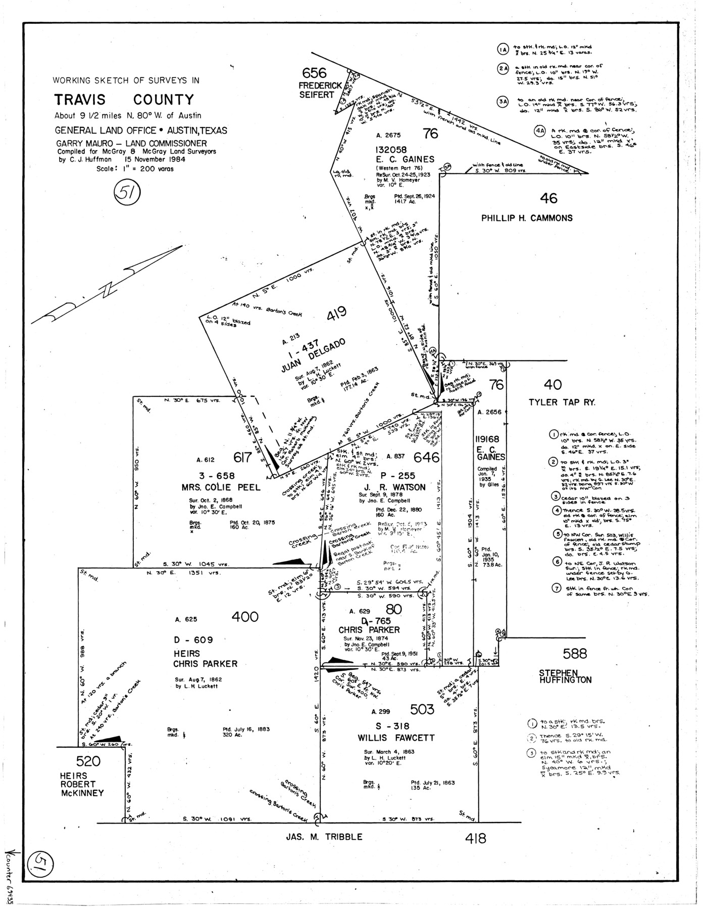
Travis County Working Sketch 51
-
Map/Doc
69435
-
Collection
General Map Collection
-
Object Dates
11/15/1984 (Creation Date)
-
People and Organizations
C.J. Huffman (Draftsman)
-
Counties
Travis
-
Subjects
Surveying Working Sketch
-
Height x Width
25.4 x 19.7 inches
64.5 x 50.0 cm
-
Scale
1" = 200 varas
Part of: General Map Collection
Map of Texas and Pacific Ry. Company's Surveys in the 80 Mile Reserve

Print $40.00
- Digital $50.00
Map of Texas and Pacific Ry. Company's Surveys in the 80 Mile Reserve
1885
Map/Doc 2241
Hardin County Working Sketch 28

Print $20.00
- Digital $50.00
Hardin County Working Sketch 28
1956
Size 18.8 x 18.9 inches
Map/Doc 63426
Jeff Davis County Working Sketch 9

Print $20.00
- Digital $50.00
Jeff Davis County Working Sketch 9
1943
Size 28.5 x 27.3 inches
Map/Doc 66504
Williamson County

Print $40.00
- Digital $50.00
Williamson County
1946
Size 40.1 x 57.7 inches
Map/Doc 63130
San Jacinto County Rolled Sketch 4

Print $20.00
- Digital $50.00
San Jacinto County Rolled Sketch 4
Size 24.3 x 32.6 inches
Map/Doc 7557
Colorado River, Wharton Sheet

Print $6.00
- Digital $50.00
Colorado River, Wharton Sheet
1941
Size 27.3 x 35.7 inches
Map/Doc 65314
Edwards County Working Sketch 25

Print $20.00
- Digital $50.00
Edwards County Working Sketch 25
1942
Size 22.6 x 20.8 inches
Map/Doc 68901
Caddo Lake and Subdivision

Print $20.00
- Digital $50.00
Caddo Lake and Subdivision
1918
Size 35.0 x 29.8 inches
Map/Doc 93283
La Salle County Working Sketch 45

Print $20.00
- Digital $50.00
La Salle County Working Sketch 45
1980
Size 35.5 x 30.7 inches
Map/Doc 70346
Coleman County Sketch File 26a

Print $3.00
- Digital $50.00
Coleman County Sketch File 26a
Size 10.6 x 15.8 inches
Map/Doc 11120
Cochran County Sketch File 2

Print $22.00
- Digital $50.00
Cochran County Sketch File 2
1907
Size 4.4 x 13.6 inches
Map/Doc 18539
Castro County Sketch File A

Print $20.00
- Digital $50.00
Castro County Sketch File A
1903
Size 25.8 x 19.4 inches
Map/Doc 11064
You may also like
Blanco County Sketch File 40

Print $4.00
- Digital $50.00
Blanco County Sketch File 40
Size 8.9 x 14.1 inches
Map/Doc 14652
Bell County Sketch File 9

Print $4.00
- Digital $50.00
Bell County Sketch File 9
Size 10.0 x 8.2 inches
Map/Doc 14379
Yoakum County Rolled Sketch 7

Print $20.00
- Digital $50.00
Yoakum County Rolled Sketch 7
2012
Size 25.9 x 18.7 inches
Map/Doc 93291
[BIock D13, north part H. & G. N. Block 2]
![90378, [BIock D13, north part H. & G. N. Block 2], Twichell Survey Records](https://historictexasmaps.com/wmedia_w700/maps/90378-1.tif.jpg)
Print $20.00
- Digital $50.00
[BIock D13, north part H. & G. N. Block 2]
Size 14.9 x 20.5 inches
Map/Doc 90378
Hall County Sketch File 32a

Print $56.00
- Digital $50.00
Hall County Sketch File 32a
1911
Size 14.4 x 8.6 inches
Map/Doc 24846
Galveston Island, showing division into lots

Print $40.00
- Digital $50.00
Galveston Island, showing division into lots
1839
Size 76.9 x 33.3 inches
Map/Doc 2036
Southern Pacific Lines in Texas and Louisiana (G. H. & S. A. Ry.) Circuit Plan of Automatic Block Signals, Automatic Train Control and Flatonia Interlocking Plant No. 3

Print $40.00
- Digital $50.00
Southern Pacific Lines in Texas and Louisiana (G. H. & S. A. Ry.) Circuit Plan of Automatic Block Signals, Automatic Train Control and Flatonia Interlocking Plant No. 3
1927
Size 43.5 x 215.5 inches
Map/Doc 90044
Pecos County Working Sketch 85

Print $20.00
- Digital $50.00
Pecos County Working Sketch 85
1962
Size 45.4 x 35.7 inches
Map/Doc 71557
Pecos County Sketch File 115

Print $18.00
- Digital $50.00
Pecos County Sketch File 115
Size 7.5 x 8.8 inches
Map/Doc 34083

Garza County Rolled Sketch 6B

Print $20.00
- Digital $50.00
Garza County Rolled Sketch 6B
Size 27.6 x 36.4 inches
Map/Doc 5996
Taylor County Sketch File 15

Print $12.00
- Digital $50.00
Taylor County Sketch File 15
1881
Size 10.1 x 8.1 inches
Map/Doc 37805