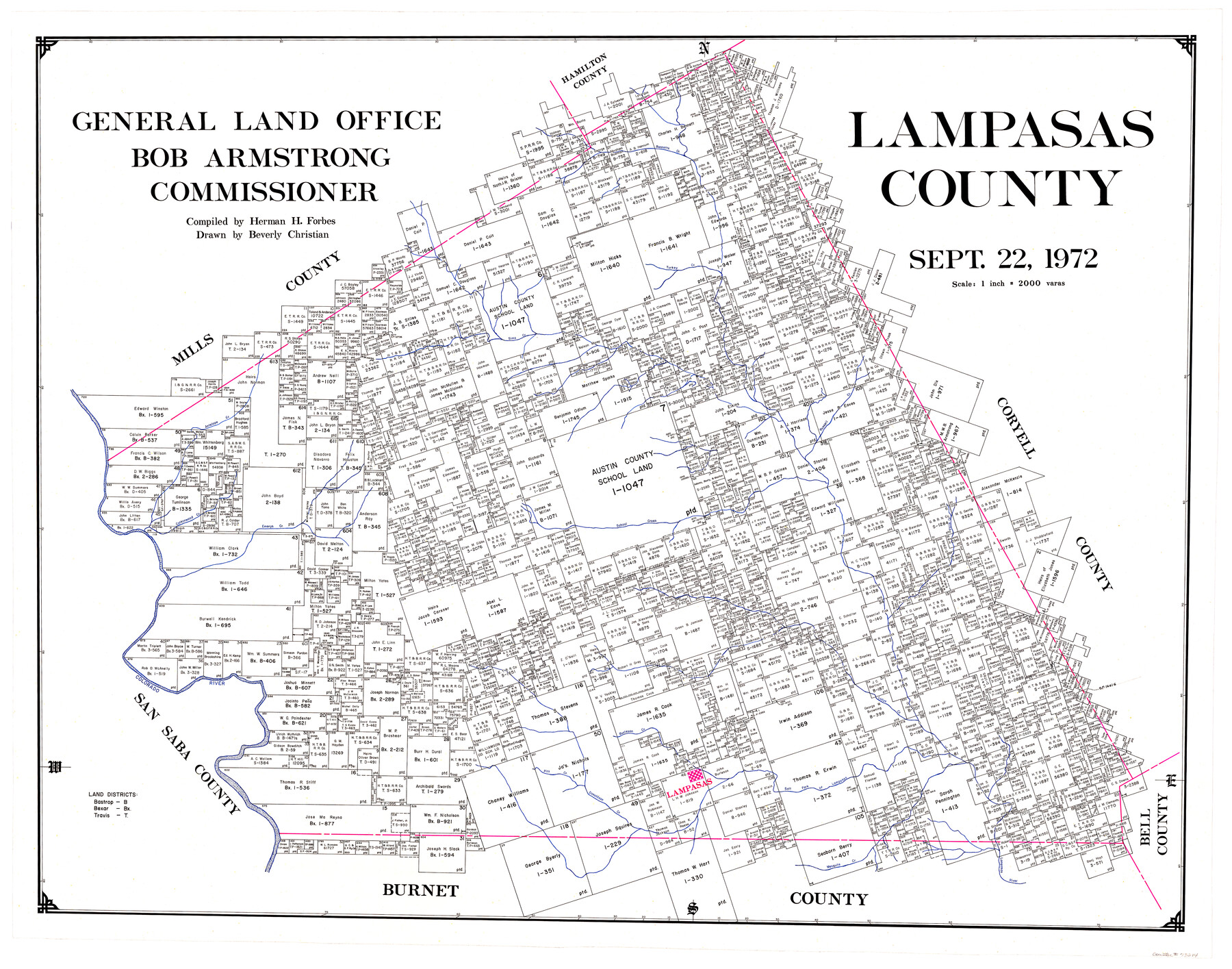
Lampasas County
-
Map/Doc
73214
-
Collection
General Map Collection
-
Object Dates
1972/9/22 (Creation Date)
-
People and Organizations
Texas General Land Office (Publisher)
Herman H. Forbes Jr. (Compiler)
Beverly Christian (Draftsman)
Bob Armstrong (GLO Commissioner)
-
Counties
Lampasas
-
Subjects
County
-
Height x Width
34.4 x 43.4 inches
87.4 x 110.2 cm
-
Comments
Leroy lettered.
-
Features
Colorado River
Mesquite Creek
Lampasas River
Salt Fork of Lampasas River
Lampasas
Donaldson Creek
Pitt Creek
Burleson Creek
Lucys Creek
Bennetts Creek
Falls Creek
School Creek
Emerys Creek
Cottonwood Creek
Antelope Creek
Russell Creek
Sims Creek
Turkey Creek
Part of: General Map Collection
Louisiana and Texas Intracoastal Waterway, Sabine River Galveston Bay Section Survey

Print $20.00
- Digital $50.00
Louisiana and Texas Intracoastal Waterway, Sabine River Galveston Bay Section Survey
1927
Size 30.7 x 43.0 inches
Map/Doc 61838
Zapata County Working Sketch 15

Print $20.00
- Digital $50.00
Zapata County Working Sketch 15
1969
Size 38.2 x 38.7 inches
Map/Doc 62066
Schleicher County Sketch File 24a

Print $20.00
- Digital $50.00
Schleicher County Sketch File 24a
Size 16.1 x 16.4 inches
Map/Doc 12303
Outer Continental Shelf Leasing Maps (Louisiana Offshore Operations)

Print $20.00
- Digital $50.00
Outer Continental Shelf Leasing Maps (Louisiana Offshore Operations)
1955
Size 17.8 x 11.6 inches
Map/Doc 76083
Aransas County Rolled Sketch 19A

Print $20.00
- Digital $50.00
Aransas County Rolled Sketch 19A
1979
Size 32.0 x 24.8 inches
Map/Doc 76068
Knox County Working Sketch 10

Print $20.00
- Digital $50.00
Knox County Working Sketch 10
Size 30.1 x 22.7 inches
Map/Doc 70252
Orange County Working Sketch 6

Print $20.00
- Digital $50.00
Orange County Working Sketch 6
1922
Size 16.2 x 20.1 inches
Map/Doc 71338
Rains County Boundary File 71

Print $6.00
- Digital $50.00
Rains County Boundary File 71
Size 8.7 x 3.5 inches
Map/Doc 58094
Right of Way Map Fort Worth & Denver City Railroad through Hardeman County

Print $40.00
- Digital $50.00
Right of Way Map Fort Worth & Denver City Railroad through Hardeman County
1885
Size 23.8 x 121.2 inches
Map/Doc 64424
Bee County Rolled Sketch 1

Print $20.00
- Digital $50.00
Bee County Rolled Sketch 1
2022
Size 24.4 x 36.0 inches
Map/Doc 97029
[Missouri, Kansas & Texas Line Map through Bastrop County]
![64030, [Missouri, Kansas & Texas Line Map through Bastrop County], General Map Collection](https://historictexasmaps.com/wmedia_w700/maps/64030.tif.jpg)
Print $40.00
- Digital $50.00
[Missouri, Kansas & Texas Line Map through Bastrop County]
1916
Size 25.5 x 74.8 inches
Map/Doc 64030
Ward County Working Sketch 42

Print $20.00
- Digital $50.00
Ward County Working Sketch 42
1970
Size 42.2 x 41.3 inches
Map/Doc 72348
You may also like
Freestone County Sketch File 6

Print $4.00
- Digital $50.00
Freestone County Sketch File 6
1858
Size 10.3 x 8.8 inches
Map/Doc 23050
Bastrop County Working Sketch 6

Print $20.00
- Digital $50.00
Bastrop County Working Sketch 6
1923
Size 37.5 x 31.2 inches
Map/Doc 67306
Flight Mission No. CLL-4N, Frame 34, Willacy County

Print $20.00
- Digital $50.00
Flight Mission No. CLL-4N, Frame 34, Willacy County
1954
Size 18.4 x 22.2 inches
Map/Doc 87107
Map of Dallas County

Print $20.00
- Digital $50.00
Map of Dallas County
1861
Size 23.5 x 20.0 inches
Map/Doc 3467
The Judicial District/County of Panola. June 24, 1841

Print $20.00
The Judicial District/County of Panola. June 24, 1841
2020
Size 19.3 x 21.7 inches
Map/Doc 96341
Val Verde County Working Sketch 69

Print $20.00
- Digital $50.00
Val Verde County Working Sketch 69
1965
Size 35.6 x 37.3 inches
Map/Doc 72204
[Sketch of part of G. & M. Block 5]
![93072, [Sketch of part of G. & M. Block 5], Twichell Survey Records](https://historictexasmaps.com/wmedia_w700/maps/93072-1.tif.jpg)
Print $2.00
- Digital $50.00
[Sketch of part of G. & M. Block 5]
Size 3.9 x 6.6 inches
Map/Doc 93072
Stonewall County Working Sketch 13

Print $20.00
- Digital $50.00
Stonewall County Working Sketch 13
1951
Size 31.9 x 33.7 inches
Map/Doc 62320
Zapata County Working Sketch 23

Print $20.00
- Digital $50.00
Zapata County Working Sketch 23
1982
Size 45.8 x 42.9 inches
Map/Doc 62074
[Sections Q, L Tech Memorial Park]
![92303, [Sections Q, L Tech Memorial Park], Twichell Survey Records](https://historictexasmaps.com/wmedia_w700/maps/92303-1.tif.jpg)
Print $20.00
- Digital $50.00
[Sections Q, L Tech Memorial Park]
1956
Size 13.0 x 17.8 inches
Map/Doc 92303
Montgomery County Working Sketch 61

Print $20.00
- Digital $50.00
Montgomery County Working Sketch 61
1963
Size 25.6 x 19.9 inches
Map/Doc 71168
Carte Geo-Hydrographique du Golfe du Mexique et de ses Isles construite d'après les mémoires les plus recens, et assujeties, pour l'emplacement de ces principales positions aux latitudes et longitudes

Print $20.00
- Digital $50.00
Carte Geo-Hydrographique du Golfe du Mexique et de ses Isles construite d'après les mémoires les plus recens, et assujeties, pour l'emplacement de ces principales positions aux latitudes et longitudes
1771
Size 15.0 x 20.5 inches
Map/Doc 94108