Old Miscellaneous File 20
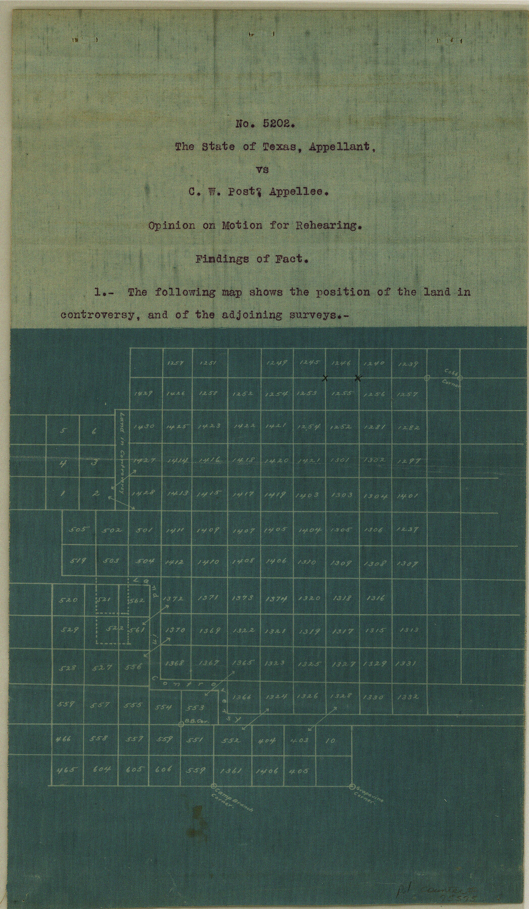
Court Opinion in Case No. 5202, The State of Texas vs. C. W. Post regarding position of surveys
-
Map/Doc
75575
-
Collection
General Map Collection
-
Object Dates
1913/10/22 (Creation Date)
1984/12/13 (File Date)
-
Subjects
Legal
-
Height x Width
13.6 x 7.9 inches
34.5 x 20.1 cm
Part of: General Map Collection
A General Map of the Southern British Colonies, in America. comprehending North and South Carolina, Georgia, East and West Florida, with the Neighbouring Indian Countries

Print $20.00
- Digital $50.00
A General Map of the Southern British Colonies, in America. comprehending North and South Carolina, Georgia, East and West Florida, with the Neighbouring Indian Countries
1776
Size 21.3 x 26.4 inches
Map/Doc 97403
Orange County Sketch File 4

Print $34.00
- Digital $50.00
Orange County Sketch File 4
1852
Size 8.2 x 7.7 inches
Map/Doc 33301
El Paso County Sketch File 22

Print $22.00
- Digital $50.00
El Paso County Sketch File 22
1888
Size 14.2 x 9.0 inches
Map/Doc 22031
Flight Mission No. BRA-6M, Frame 143, Jefferson County

Print $20.00
- Digital $50.00
Flight Mission No. BRA-6M, Frame 143, Jefferson County
1953
Size 18.5 x 22.2 inches
Map/Doc 85444
Galveston County Rolled Sketch 17

Print $20.00
- Digital $50.00
Galveston County Rolled Sketch 17
1940
Size 40.4 x 35.4 inches
Map/Doc 9079
Nueces County Rolled Sketch 86

Print $167.00
Nueces County Rolled Sketch 86
1983
Size 18.2 x 24.7 inches
Map/Doc 6978
University Lands Blocks 1-13 & Block 58, Crockett, Reagan & Upton Counties

Print $20.00
- Digital $50.00
University Lands Blocks 1-13 & Block 58, Crockett, Reagan & Upton Counties
1936
Size 37.3 x 42.0 inches
Map/Doc 2445
Maps of Gulf Intracoastal Waterway, Texas - Sabine River to the Rio Grande and connecting waterways including ship channels

Print $20.00
- Digital $50.00
Maps of Gulf Intracoastal Waterway, Texas - Sabine River to the Rio Grande and connecting waterways including ship channels
1966
Size 14.7 x 21.0 inches
Map/Doc 61992
Texas Intracoastal Waterway, Aransas Bay to Aransas Pass

Print $20.00
- Digital $50.00
Texas Intracoastal Waterway, Aransas Bay to Aransas Pass
1962
Size 26.8 x 38.7 inches
Map/Doc 73438
Crosby County Working Sketch 2

Print $20.00
- Digital $50.00
Crosby County Working Sketch 2
Size 18.2 x 18.0 inches
Map/Doc 68436
Aransas County NRC Article 33.136 Sketch 9

Print $24.00
- Digital $50.00
Aransas County NRC Article 33.136 Sketch 9
2013
Size 24.0 x 36.0 inches
Map/Doc 94469
Tyler County Working Sketch 19

Print $20.00
- Digital $50.00
Tyler County Working Sketch 19
1967
Size 47.8 x 42.9 inches
Map/Doc 69489
You may also like
Val Verde County Working Sketch 64

Print $20.00
- Digital $50.00
Val Verde County Working Sketch 64
1959
Size 19.0 x 43.0 inches
Map/Doc 72199
Austin, State Capital of Texas

Digital $50.00
Austin, State Capital of Texas
1887
Size 23.0 x 32.1 inches
Map/Doc 90092
Marion County Boundary File 61

Print $6.00
- Digital $50.00
Marion County Boundary File 61
Size 12.8 x 8.2 inches
Map/Doc 56816
Harris County Working Sketch 112

Print $20.00
- Digital $50.00
Harris County Working Sketch 112
1982
Size 31.0 x 38.1 inches
Map/Doc 66004
Bexar County Sketch File 41

Print $4.00
- Digital $50.00
Bexar County Sketch File 41
Size 8.3 x 5.3 inches
Map/Doc 14516

Howard County Sketch File 7

Print $20.00
- Digital $50.00
Howard County Sketch File 7
Size 21.7 x 13.8 inches
Map/Doc 11795
Nueces County Sketch File 33

Print $20.00
- Digital $50.00
Nueces County Sketch File 33
1908
Size 22.0 x 19.2 inches
Map/Doc 42188
Flight Mission No. DIX-5P, Frame 114, Aransas County

Print $20.00
- Digital $50.00
Flight Mission No. DIX-5P, Frame 114, Aransas County
1956
Size 17.4 x 17.6 inches
Map/Doc 83793
Jeff Davis County Sketch File 17

Print $6.00
- Digital $50.00
Jeff Davis County Sketch File 17
1884
Size 8.8 x 7.3 inches
Map/Doc 27948
Van Zandt County Sketch File 16b

Print $2.00
- Digital $50.00
Van Zandt County Sketch File 16b
Size 12.8 x 8.3 inches
Map/Doc 39416
Flight Mission No. BRE-1P, Frame 57, Nueces County

Print $20.00
- Digital $50.00
Flight Mission No. BRE-1P, Frame 57, Nueces County
1956
Size 18.5 x 22.2 inches
Map/Doc 86646