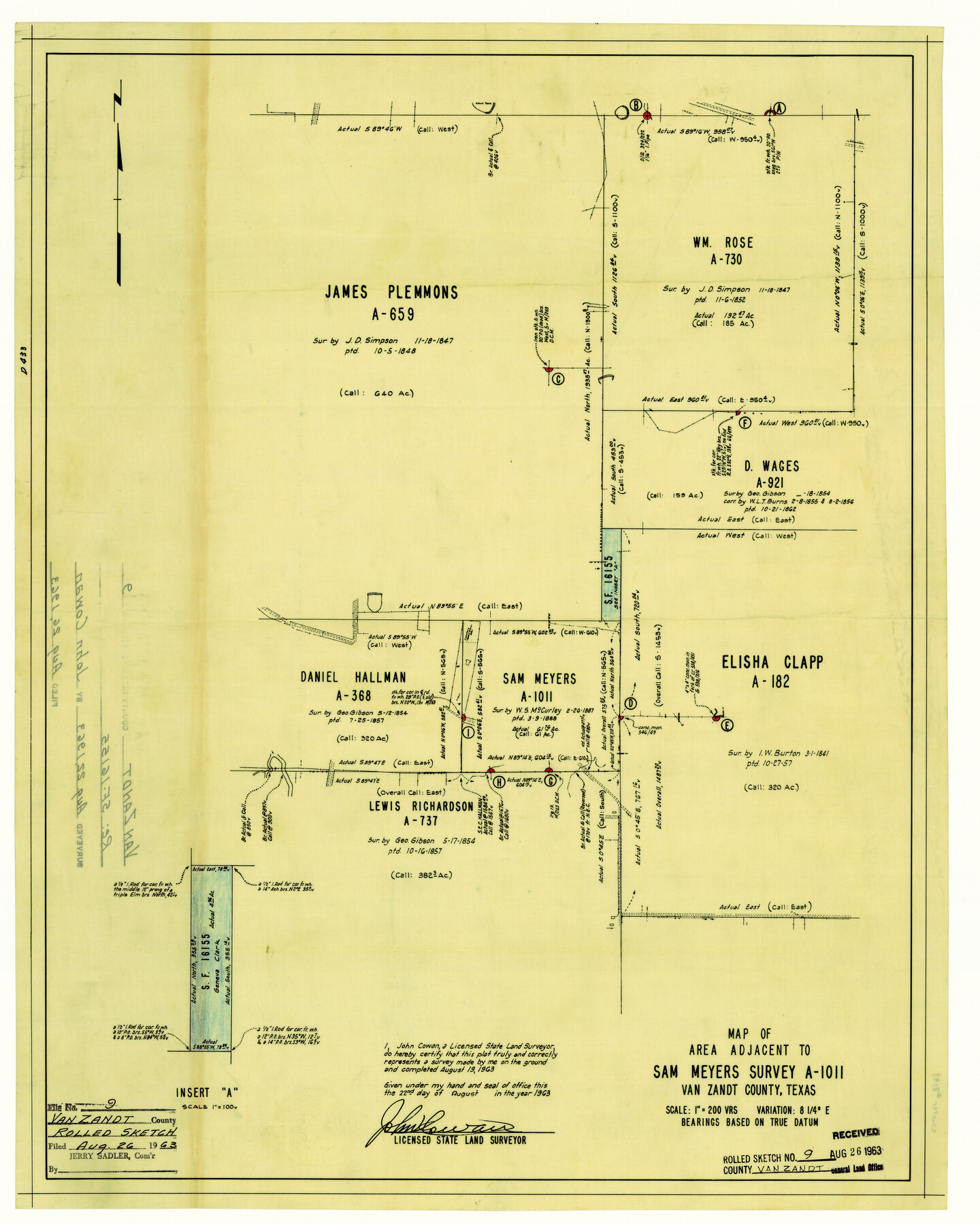
Van Zandt County Rolled Sketch 9
Map of area adjacent to Sam Meyers survey A-1011, Van Zandt County, Texas
-
Map/Doc
8149
-
Collection
General Map Collection
-
Object Dates
1963/8/22 (Creation Date)
1963/8/26 (File Date)
-
People and Organizations
John Cowan (Surveyor/Engineer)
-
Counties
Van Zandt
-
Subjects
Surveying Rolled Sketch
-
Height x Width
23.4 x 18.7 inches
59.4 x 47.5 cm
-
Medium
linen, manuscript
-
Scale
1" = 200 varas
Part of: General Map Collection
Hunt County Sketch File 5

Print $4.00
- Digital $50.00
Hunt County Sketch File 5
1851
Size 12.9 x 8.2 inches
Map/Doc 27091
Chambers County NRC Article 33.136 Sketch 13

Print $22.00
Chambers County NRC Article 33.136 Sketch 13
Size 35.9 x 23.2 inches
Map/Doc 97014
Houston County Rolled Sketch 10

Print $20.00
- Digital $50.00
Houston County Rolled Sketch 10
1988
Size 31.9 x 25.3 inches
Map/Doc 6230
Dickens County Working Sketch 4

Print $20.00
- Digital $50.00
Dickens County Working Sketch 4
1914
Size 27.9 x 18.8 inches
Map/Doc 68651
Nueces County NRC Article 33.136 Sketch 17

Print $26.00
- Digital $50.00
Nueces County NRC Article 33.136 Sketch 17
2013
Size 18.0 x 24.0 inches
Map/Doc 94487
Map of the country adjacent to the left bank of the Rio Grande below Matamoros surveyed under instructions of Col. J.J. Abert, Corps. Top. Engrs.

Print $20.00
- Digital $50.00
Map of the country adjacent to the left bank of the Rio Grande below Matamoros surveyed under instructions of Col. J.J. Abert, Corps. Top. Engrs.
Size 27.0 x 20.9 inches
Map/Doc 95177
Intracoastal Waterway in Texas - Corpus Christi to Point Isabel including Arroyo Colorado to Mo. Pac. R.R. Bridge Near Harlingen

Print $20.00
- Digital $50.00
Intracoastal Waterway in Texas - Corpus Christi to Point Isabel including Arroyo Colorado to Mo. Pac. R.R. Bridge Near Harlingen
1933
Size 40.9 x 27.8 inches
Map/Doc 61874
Gray County Boundary File 9

Print $6.00
- Digital $50.00
Gray County Boundary File 9
Size 11.6 x 9.1 inches
Map/Doc 53902
Titus County Sketch File 14

Print $4.00
- Digital $50.00
Titus County Sketch File 14
Size 9.7 x 8.3 inches
Map/Doc 38157
Williamson County Sketch File 13a

Print $4.00
- Digital $50.00
Williamson County Sketch File 13a
1871
Size 8.1 x 13.6 inches
Map/Doc 40330
Glasscock County Sketch File 25

Print $20.00
- Digital $50.00
Glasscock County Sketch File 25
1951
Size 28.8 x 20.6 inches
Map/Doc 11566
Flight Mission No. DIX-6P, Frame 185, Aransas County

Print $20.00
- Digital $50.00
Flight Mission No. DIX-6P, Frame 185, Aransas County
1956
Size 19.1 x 22.8 inches
Map/Doc 83847
You may also like
Trinity River, Map of J. B. Bradley's Levee in Valley of Cummins Creek about 2 1/2 Miles South of Rice Showing Proposed Change of Location

Print $2.00
- Digital $50.00
Trinity River, Map of J. B. Bradley's Levee in Valley of Cummins Creek about 2 1/2 Miles South of Rice Showing Proposed Change of Location
1950
Size 13.9 x 16.1 inches
Map/Doc 65246
Kleberg County Rolled Sketch 10-29

Print $20.00
- Digital $50.00
Kleberg County Rolled Sketch 10-29
1952
Size 37.6 x 33.8 inches
Map/Doc 9373
King County Working Sketch 17

Print $40.00
- Digital $50.00
King County Working Sketch 17
1979
Size 32.2 x 59.3 inches
Map/Doc 70181
Upton County Working Sketch 38

Print $20.00
- Digital $50.00
Upton County Working Sketch 38
1957
Size 23.3 x 32.8 inches
Map/Doc 69534
San Patricio County, Texas

Print $20.00
- Digital $50.00
San Patricio County, Texas
1879
Size 18.1 x 22.8 inches
Map/Doc 611
Donley County Sketch File B11

Print $4.00
- Digital $50.00
Donley County Sketch File B11
1952
Size 11.5 x 9.0 inches
Map/Doc 21274
Flight Mission No. CUG-1P, Frame 27, Kleberg County

Print $20.00
- Digital $50.00
Flight Mission No. CUG-1P, Frame 27, Kleberg County
1956
Size 18.4 x 22.1 inches
Map/Doc 86117
Stephens County Working Sketch 9

Print $20.00
- Digital $50.00
Stephens County Working Sketch 9
1920
Size 16.3 x 14.6 inches
Map/Doc 63952
Flight Mission No. DQN-2K, Frame 72, Calhoun County

Print $20.00
- Digital $50.00
Flight Mission No. DQN-2K, Frame 72, Calhoun County
1953
Size 18.6 x 22.3 inches
Map/Doc 84264
Cottle County

Print $20.00
- Digital $50.00
Cottle County
1908
Size 45.0 x 41.0 inches
Map/Doc 66789
Flight Mission No. DQN-1K, Frame 28, Calhoun County

Print $20.00
- Digital $50.00
Flight Mission No. DQN-1K, Frame 28, Calhoun County
1953
Size 18.5 x 22.3 inches
Map/Doc 84133
Hockley County Sketch File 5

Print $4.00
- Digital $50.00
Hockley County Sketch File 5
Size 9.1 x 11.2 inches
Map/Doc 26539