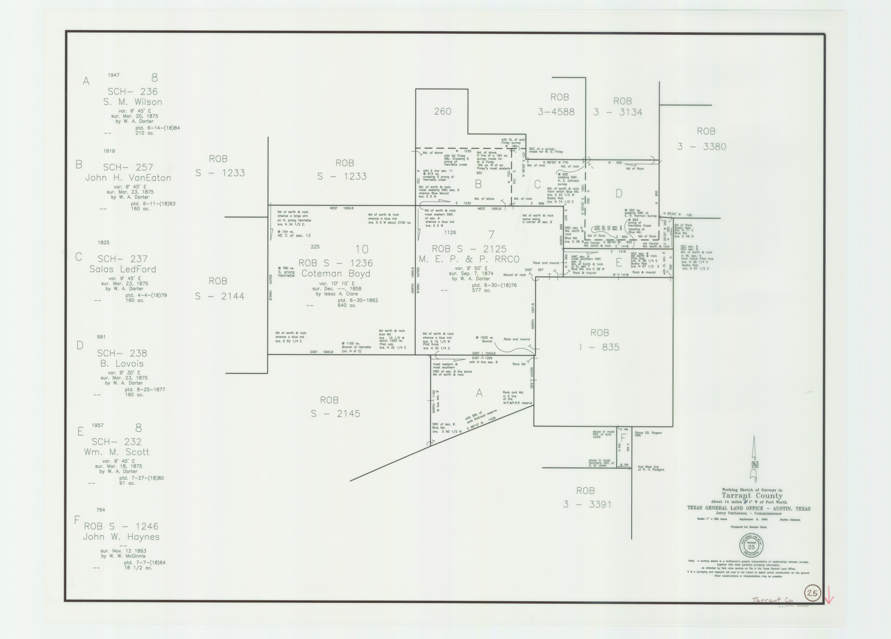
Tarrant County Working Sketch 25
-
Map/Doc
83585
-
Collection
General Map Collection
-
Object Dates
9/8/2004 (Creation Date)
-
People and Organizations
Jerry E. Patterson (GLO Commissioner)
Dustin Johnson (Draftsman)
-
Counties
Tarrant
-
Subjects
Surveying Working Sketch
-
Height x Width
27.3 x 38.0 inches
69.3 x 96.5 cm
-
Scale
1" = 300 varas
-
Comments
Located about 14 miles North 1 degree West of Fort Worth, Texas.
Part of: General Map Collection
Liberty County Working Sketch 29

Print $20.00
- Digital $50.00
Liberty County Working Sketch 29
1943
Size 27.3 x 17.0 inches
Map/Doc 70488
King County Rolled Sketch 12

Print $20.00
- Digital $50.00
King County Rolled Sketch 12
1955
Size 40.9 x 45.7 inches
Map/Doc 9352
Controlled Mosaic by Jack Amman Photogrammetric Engineers, Inc - Sheet 18

Print $20.00
- Digital $50.00
Controlled Mosaic by Jack Amman Photogrammetric Engineers, Inc - Sheet 18
1954
Size 19.4 x 24.0 inches
Map/Doc 83463
Flight Mission No. BQY-4M, Frame 55, Harris County

Print $20.00
- Digital $50.00
Flight Mission No. BQY-4M, Frame 55, Harris County
1953
Size 18.5 x 22.3 inches
Map/Doc 85264
Donley County Working Sketch 10

Print $20.00
- Digital $50.00
Donley County Working Sketch 10
1982
Size 35.1 x 41.1 inches
Map/Doc 68743
Harris County Historic Topographic 26

Print $20.00
- Digital $50.00
Harris County Historic Topographic 26
1916
Size 29.2 x 22.8 inches
Map/Doc 65837
Sutton County Working Sketch 62

Print $20.00
- Digital $50.00
Sutton County Working Sketch 62
1959
Size 31.3 x 38.1 inches
Map/Doc 62405
Duval County Rolled Sketch 39

Print $20.00
- Digital $50.00
Duval County Rolled Sketch 39
1956
Size 29.0 x 20.1 inches
Map/Doc 5756
Flight Mission No. BRA-7M, Frame 4, Jefferson County

Print $20.00
- Digital $50.00
Flight Mission No. BRA-7M, Frame 4, Jefferson County
1953
Size 18.7 x 22.2 inches
Map/Doc 85455
Terrell County Rolled Sketch 51A

Print $20.00
- Digital $50.00
Terrell County Rolled Sketch 51A
1957
Size 29.1 x 20.6 inches
Map/Doc 7968
Floyd County Rolled Sketch 9

Print $323.00
- Digital $50.00
Floyd County Rolled Sketch 9
1953
Size 10.0 x 15.7 inches
Map/Doc 44564

You may also like
Lamb County Sketch File 17

Print $20.00
- Digital $50.00
Lamb County Sketch File 17
1940
Size 25.4 x 12.3 inches
Map/Doc 11973
![94161, Austin and Vicinity [Verso], General Map Collection](https://historictexasmaps.com/wmedia_w700/maps/94161.tif.jpg)
Maps of Gulf Intracoastal Waterway, Texas - Sabine River to the Rio Grande and connecting waterways including ship channels

Print $20.00
- Digital $50.00
Maps of Gulf Intracoastal Waterway, Texas - Sabine River to the Rio Grande and connecting waterways including ship channels
1966
Size 14.6 x 22.3 inches
Map/Doc 61959
Hudspeth County Rolled Sketch 69

Print $20.00
- Digital $50.00
Hudspeth County Rolled Sketch 69
1973
Size 13.3 x 20.5 inches
Map/Doc 7716
Navarro County Sketch File 8

Print $4.00
- Digital $50.00
Navarro County Sketch File 8
1849
Size 13.2 x 8.5 inches
Map/Doc 32315
Crockett County Working Sketch 93

Print $40.00
- Digital $50.00
Crockett County Working Sketch 93
1979
Size 43.5 x 65.4 inches
Map/Doc 68426
Cooke County Sketch File 30

Print $4.00
- Digital $50.00
Cooke County Sketch File 30
Size 8.8 x 5.5 inches
Map/Doc 19291
Sulphur River, Turner Lake Sheet, Cuthand Creek

Print $20.00
- Digital $50.00
Sulphur River, Turner Lake Sheet, Cuthand Creek
1922
Size 28.5 x 34.3 inches
Map/Doc 65157
Hutchinson County Working Sketch 14

Print $20.00
- Digital $50.00
Hutchinson County Working Sketch 14
1930
Size 18.4 x 25.8 inches
Map/Doc 66372
Johnson County Working Sketch 25

Print $20.00
- Digital $50.00
Johnson County Working Sketch 25
1998
Size 13.3 x 25.4 inches
Map/Doc 66638
Sectional map of Texas traversed by the Missouri, Kansas & Texas Railway, showing the crops adapted to each section, with the elevation and annual rainfall

Print $20.00
- Digital $50.00
Sectional map of Texas traversed by the Missouri, Kansas & Texas Railway, showing the crops adapted to each section, with the elevation and annual rainfall
1908
Size 22.0 x 22.9 inches
Map/Doc 95816
Menard County Working Sketch 9

Print $20.00
- Digital $50.00
Menard County Working Sketch 9
1937
Size 22.9 x 22.5 inches
Map/Doc 70956