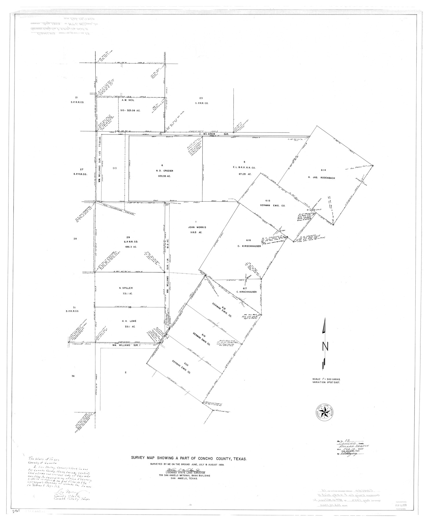
Concho County Rolled Sketch 15
Survey map showing a part of Concho County, Texas
-
Map/Doc
8660
-
Collection
General Map Collection
-
Object Dates
1959 (Creation Date)
1960/2/15 (File Date)
-
People and Organizations
Wm. C. Wilson, Jr. (Surveyor/Engineer)
-
Counties
Concho
-
Subjects
Surveying Rolled Sketch
-
Height x Width
48.3 x 39.5 inches
122.7 x 100.3 cm
-
Scale
1" = 300 varas
Part of: General Map Collection

Kent County Sketch File 7

Print $20.00
- Digital $50.00
Kent County Sketch File 7
1902
Size 21.7 x 37.6 inches
Map/Doc 10514
Comanche County Working Sketch 11

Print $20.00
- Digital $50.00
Comanche County Working Sketch 11
1955
Size 31.7 x 43.3 inches
Map/Doc 68145
El Paso County Sketch File 22

Print $22.00
- Digital $50.00
El Paso County Sketch File 22
1888
Size 14.2 x 9.0 inches
Map/Doc 22031
Dickens County Rolled Sketch 10

Print $20.00
- Digital $50.00
Dickens County Rolled Sketch 10
Size 43.0 x 31.9 inches
Map/Doc 8789
Scurry County Rolled Sketch 10

Print $20.00
- Digital $50.00
Scurry County Rolled Sketch 10
1966
Size 22.7 x 18.3 inches
Map/Doc 7770
Hockley County Sketch File 5

Print $4.00
- Digital $50.00
Hockley County Sketch File 5
Size 9.1 x 11.2 inches
Map/Doc 26539
Dawson County Working Sketch 16

Print $20.00
- Digital $50.00
Dawson County Working Sketch 16
1956
Size 13.9 x 18.8 inches
Map/Doc 68560
Map of Africa engraved to illustrate Mitchell's new intermediate geography (Inset 1: Map of Egypt / Inset 2: Liberia and Sierra Leone)

Print $20.00
- Digital $50.00
Map of Africa engraved to illustrate Mitchell's new intermediate geography (Inset 1: Map of Egypt / Inset 2: Liberia and Sierra Leone)
1885
Size 9.0 x 12.2 inches
Map/Doc 93530
Jim Hogg County Rolled Sketch 3

Print $20.00
- Digital $50.00
Jim Hogg County Rolled Sketch 3
1912
Size 28.2 x 20.2 inches
Map/Doc 6439
Floyd County Sketch File 1

Print $5.00
- Digital $50.00
Floyd County Sketch File 1
Size 11.0 x 17.0 inches
Map/Doc 22688
Montgomery Co.

Print $40.00
- Digital $50.00
Montgomery Co.
1943
Size 45.2 x 54.8 inches
Map/Doc 95594
You may also like
Sketch Showing Division Fence Shelton- Matador, Oldham County

Print $20.00
- Digital $50.00
Sketch Showing Division Fence Shelton- Matador, Oldham County
Size 21.6 x 24.4 inches
Map/Doc 91484
The Judicial District/County of Menard. December 7, 1841

Print $20.00
The Judicial District/County of Menard. December 7, 1841
2020
Size 22.4 x 21.7 inches
Map/Doc 96336
Henderson County Sketch File 18

Print $20.00
- Digital $50.00
Henderson County Sketch File 18
1936
Size 16.7 x 18.3 inches
Map/Doc 11756
Colorado County Working Sketch 2

Print $20.00
- Digital $50.00
Colorado County Working Sketch 2
1904
Size 28.8 x 30.1 inches
Map/Doc 68102
[Beaumont, Sour Lake and Western Ry. Right of Way and Alignment - Frisco]
![64117, [Beaumont, Sour Lake and Western Ry. Right of Way and Alignment - Frisco], General Map Collection](https://historictexasmaps.com/wmedia_w700/maps/64117.tif.jpg)
Print $20.00
- Digital $50.00
[Beaumont, Sour Lake and Western Ry. Right of Way and Alignment - Frisco]
1910
Size 20.2 x 45.9 inches
Map/Doc 64117
Cooke County Working Sketch 15

Print $20.00
- Digital $50.00
Cooke County Working Sketch 15
1946
Size 29.9 x 23.5 inches
Map/Doc 68252
Ward County Working Sketch 30

Print $40.00
- Digital $50.00
Ward County Working Sketch 30
1964
Size 118.5 x 43.4 inches
Map/Doc 72336
Henderson County Rolled Sketch 11

Print $20.00
- Digital $50.00
Henderson County Rolled Sketch 11
1915
Size 29.4 x 42.2 inches
Map/Doc 75949
[Tracing from Mabry's Working Sketch in Southwest Oldham County]
![91474, [Tracing from Mabry's Working Sketch in Southwest Oldham County], Twichell Survey Records](https://historictexasmaps.com/wmedia_w700/maps/91474-1.tif.jpg)
Print $20.00
- Digital $50.00
[Tracing from Mabry's Working Sketch in Southwest Oldham County]
Size 19.3 x 19.8 inches
Map/Doc 91474
Harris County Boundary File 2

Print $8.00
- Digital $50.00
Harris County Boundary File 2
Size 8.1 x 8.7 inches
Map/Doc 54294
Lampasas County Sketch File 11

Print $4.00
- Digital $50.00
Lampasas County Sketch File 11
1874
Size 12.2 x 7.9 inches
Map/Doc 29420
Brazoria County Rolled Sketch 29

Print $20.00
- Digital $50.00
Brazoria County Rolled Sketch 29
1931
Size 41.4 x 29.1 inches
Map/Doc 5167