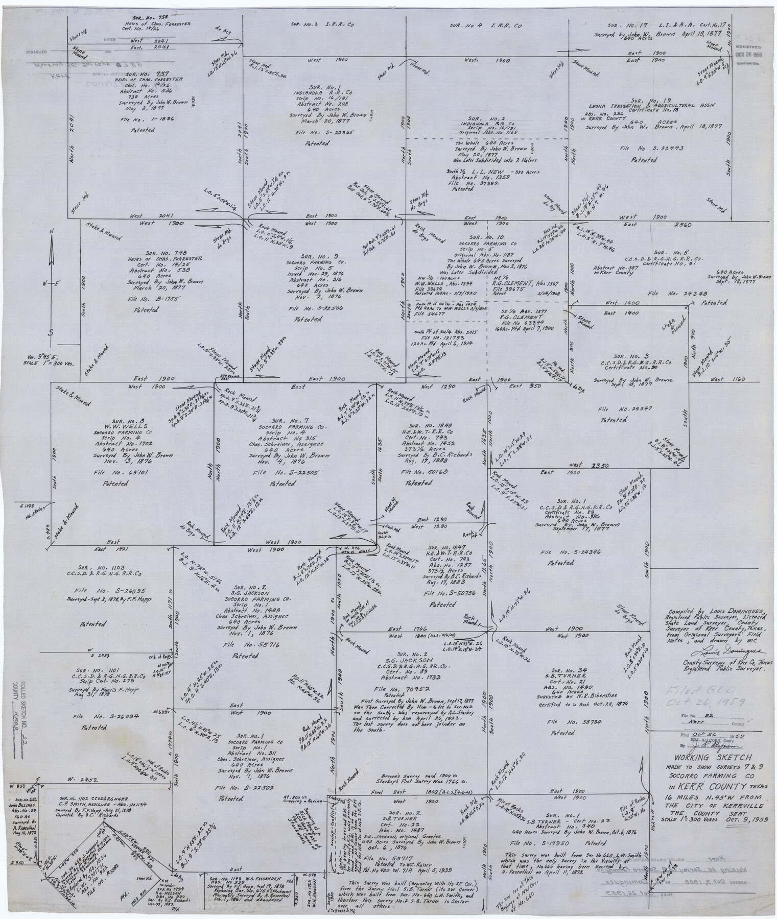
Kerr County Rolled Sketch 22
Working Sketch made to show surveys 7 & 9, Socorro Farming Co. in Kerr County, Texas
-
Map/Doc
9349
-
Collection
General Map Collection
-
Object Dates
1959/10/9 (Creation Date)
1959/10/26 (File Date)
-
People and Organizations
Louis Domingues (Surveyor/Engineer)
-
Counties
Kerr
-
Subjects
Surveying Rolled Sketch
-
Height x Width
35.7 x 30.2 inches
90.7 x 76.7 cm
-
Medium
linen, manuscript
-
Scale
1" = 300 varas
Part of: General Map Collection
Flight Mission No. BRA-8M, Frame 148, Jefferson County

Print $20.00
- Digital $50.00
Flight Mission No. BRA-8M, Frame 148, Jefferson County
1953
Size 18.8 x 22.5 inches
Map/Doc 85640
Gaines County Sketch File 2a

Print $16.00
- Digital $50.00
Gaines County Sketch File 2a
Size 9.0 x 8.9 inches
Map/Doc 23167
Burnet County Boundary File 7a

Print $30.00
- Digital $50.00
Burnet County Boundary File 7a
Size 14.1 x 8.5 inches
Map/Doc 50902
Nueces County NRC Article 33.136 Sketch 5

Print $48.00
- Digital $50.00
Nueces County NRC Article 33.136 Sketch 5
2002
Size 22.9 x 34.7 inches
Map/Doc 78666
Flight Mission No. DQN-2K, Frame 68, Calhoun County

Print $20.00
- Digital $50.00
Flight Mission No. DQN-2K, Frame 68, Calhoun County
1953
Size 18.6 x 22.2 inches
Map/Doc 84260
Pecos County Sketch File 48

Print $4.00
- Digital $50.00
Pecos County Sketch File 48
1935
Size 14.3 x 8.8 inches
Map/Doc 33762
Hudspeth County Rolled Sketch 19

Print $20.00
- Digital $50.00
Hudspeth County Rolled Sketch 19
Size 47.8 x 44.6 inches
Map/Doc 9205
Brewster County Rolled Sketch 101

Print $40.00
- Digital $50.00
Brewster County Rolled Sketch 101
1927
Size 55.0 x 40.0 inches
Map/Doc 8509
Jack County Sketch File 13

Print $4.00
- Digital $50.00
Jack County Sketch File 13
Size 10.3 x 8.0 inches
Map/Doc 27537
Flight Mission No. BRA-8M, Frame 71, Jefferson County

Print $20.00
- Digital $50.00
Flight Mission No. BRA-8M, Frame 71, Jefferson County
1953
Size 18.7 x 22.3 inches
Map/Doc 85591
Ward County Working Sketch 47

Print $20.00
- Digital $50.00
Ward County Working Sketch 47
1974
Size 41.3 x 33.9 inches
Map/Doc 72353
Somervell County

Print $20.00
- Digital $50.00
Somervell County
1941
Size 28.1 x 26.1 inches
Map/Doc 73291
You may also like
A Map of that part of Young District south of old Fannin District line

Print $20.00
- Digital $50.00
A Map of that part of Young District south of old Fannin District line
1861
Size 24.9 x 38.0 inches
Map/Doc 1979
Val Verde County Rolled Sketch 57

Print $40.00
- Digital $50.00
Val Verde County Rolled Sketch 57
1947
Size 53.6 x 48.9 inches
Map/Doc 10077
Throckmorton County Boundary File 4

Print $6.00
- Digital $50.00
Throckmorton County Boundary File 4
Size 14.3 x 8.8 inches
Map/Doc 59283
King County Boundary File 3

Print $54.00
- Digital $50.00
King County Boundary File 3
Size 14.1 x 8.5 inches
Map/Doc 64896
[S.P.R.R.Co. Blocks 15 &16]
![92355, [S.P.R.R.Co. Blocks 15 &16], Twichell Survey Records](https://historictexasmaps.com/wmedia_w700/maps/92355-1.tif.jpg)
Print $20.00
- Digital $50.00
[S.P.R.R.Co. Blocks 15 &16]
Size 37.3 x 32.3 inches
Map/Doc 92355
Nueces County Working Sketch 3

Print $20.00
- Digital $50.00
Nueces County Working Sketch 3
1972
Size 38.9 x 45.0 inches
Map/Doc 71305
Harris County Working Sketch 117

Print $20.00
- Digital $50.00
Harris County Working Sketch 117
1984
Size 28.2 x 25.5 inches
Map/Doc 66009
Flight Mission No. CGI-1N, Frame 214, Cameron County

Print $20.00
- Digital $50.00
Flight Mission No. CGI-1N, Frame 214, Cameron County
1955
Size 18.5 x 22.1 inches
Map/Doc 84523
Sterling County Rolled Sketch 29

Print $20.00
- Digital $50.00
Sterling County Rolled Sketch 29
Size 30.0 x 23.5 inches
Map/Doc 7854
Liberty County Rolled Sketch N

Print $20.00
- Digital $50.00
Liberty County Rolled Sketch N
Size 44.7 x 38.5 inches
Map/Doc 10180
Austin County Sketch File 4

Print $8.00
- Digital $50.00
Austin County Sketch File 4
1881
Size 12.9 x 8.3 inches
Map/Doc 13857
Hidalgo County

Print $20.00
- Digital $50.00
Hidalgo County
1911
Size 42.1 x 28.7 inches
Map/Doc 16850