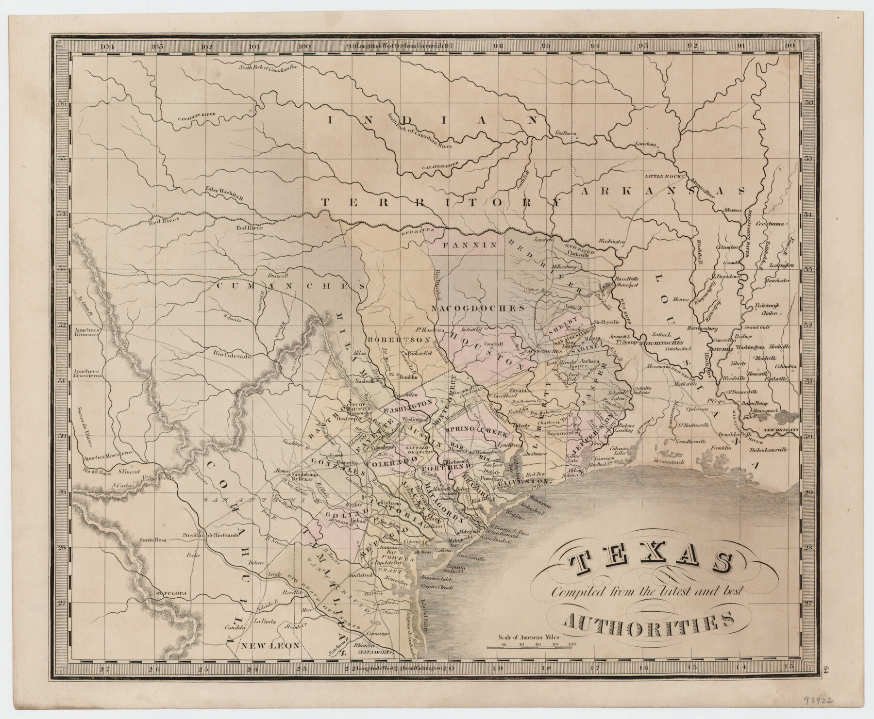
Texas compiled from the latest and best authorities
-
Map/Doc
93922
-
Collection
General Map Collection
-
Object Dates
1845 (Creation Date)
2015/7/24 (File Date)
-
People and Organizations
[Jeremiah Greenleaf] (Author)
-
Subjects
Republic of Texas
-
Height x Width
12.0 x 14.6 inches
30.5 x 37.1 cm
-
Medium
paper, etching/engraving/lithograph
Part of: General Map Collection
Gaines County Working Sketch 26

Print $20.00
- Digital $50.00
Gaines County Working Sketch 26
1983
Size 34.1 x 39.7 inches
Map/Doc 69326
Andrews County Working Sketch 12

Print $20.00
- Digital $50.00
Andrews County Working Sketch 12
1956
Size 35.5 x 25.3 inches
Map/Doc 67058
Hemphill County, State of Texas

Print $20.00
- Digital $50.00
Hemphill County, State of Texas
1888
Size 22.0 x 17.4 inches
Map/Doc 6187
San Patricio County Rolled Sketch 22

Print $20.00
- Digital $50.00
San Patricio County Rolled Sketch 22
1882
Size 19.3 x 23.9 inches
Map/Doc 7581
Maverick County Sketch File 10

Print $22.00
- Digital $50.00
Maverick County Sketch File 10
Size 8.6 x 7.0 inches
Map/Doc 31072

Hutchinson County Sketch File 48

Print $38.00
- Digital $50.00
Hutchinson County Sketch File 48
1989
Size 11.2 x 8.8 inches
Map/Doc 27400
Burnet County Working Sketch 6

Print $20.00
- Digital $50.00
Burnet County Working Sketch 6
1958
Size 20.5 x 31.0 inches
Map/Doc 67849
Loving County Rolled Sketch 14

Print $20.00
- Digital $50.00
Loving County Rolled Sketch 14
2006
Size 11.4 x 17.5 inches
Map/Doc 93381
Zapata County Sketch File 1

Print $20.00
- Digital $50.00
Zapata County Sketch File 1
1875
Size 30.5 x 21.4 inches
Map/Doc 12717
Pottsboro Quadrangle

Print $20.00
- Digital $50.00
Pottsboro Quadrangle
1999
Size 35.4 x 23.4 inches
Map/Doc 97363
Andrews County Rolled Sketch 8

Print $40.00
- Digital $50.00
Andrews County Rolled Sketch 8
1928
Size 31.4 x 54.0 inches
Map/Doc 8388
You may also like
Knox County Sketch File 10a

Print $40.00
- Digital $50.00
Knox County Sketch File 10a
1902
Size 9.5 x 19.0 inches
Map/Doc 29223
Reeves County

Print $20.00
- Digital $50.00
Reeves County
1915
Size 23.6 x 29.8 inches
Map/Doc 92896
Harris County Working Sketch 114

Print $20.00
- Digital $50.00
Harris County Working Sketch 114
1983
Size 37.6 x 29.0 inches
Map/Doc 66006
General Highway Map, Cass County, Texas

Print $20.00
General Highway Map, Cass County, Texas
1940
Size 18.6 x 25.2 inches
Map/Doc 79042
Battlefields of the Civil War

Battlefields of the Civil War
1961
Size 25.8 x 19.7 inches
Map/Doc 92374
Gaines County Rolled Sketch 14

Print $40.00
- Digital $50.00
Gaines County Rolled Sketch 14
Size 23.8 x 325.9 inches
Map/Doc 9030
Navasota River, Springfield Sheet

Print $20.00
- Digital $50.00
Navasota River, Springfield Sheet
1934
Size 41.5 x 37.8 inches
Map/Doc 65074
Terrell County Working Sketch 66

Print $40.00
- Digital $50.00
Terrell County Working Sketch 66
1972
Size 32.1 x 48.1 inches
Map/Doc 69587
Map and Profile No. 1 from the Red River to the Rio Grande; from Explorations and surveys made under the direction of the Hon. Jeffeson Davis, Secretary of War

Print $40.00
- Digital $50.00
Map and Profile No. 1 from the Red River to the Rio Grande; from Explorations and surveys made under the direction of the Hon. Jeffeson Davis, Secretary of War
1856
Size 30.5 x 57.0 inches
Map/Doc 4330
Atlas T - Titles to Frontier Settlers issued by the Commissioner Carlos S. Taylor

Atlas T - Titles to Frontier Settlers issued by the Commissioner Carlos S. Taylor
1834
Map/Doc 94536
[East Line & Red River Railroad from Sulphur Springs to Jefferson]
![64768, [East Line & Red River Railroad from Sulphur Springs to Jefferson], General Map Collection](https://historictexasmaps.com/wmedia_w700/maps/64768.tif.jpg)
Print $40.00
- Digital $50.00
[East Line & Red River Railroad from Sulphur Springs to Jefferson]
1879
Size 38.0 x 108.5 inches
Map/Doc 64768
Duval County Working Sketch 52

Print $20.00
- Digital $50.00
Duval County Working Sketch 52
1942
Size 22.1 x 25.9 inches
Map/Doc 68776