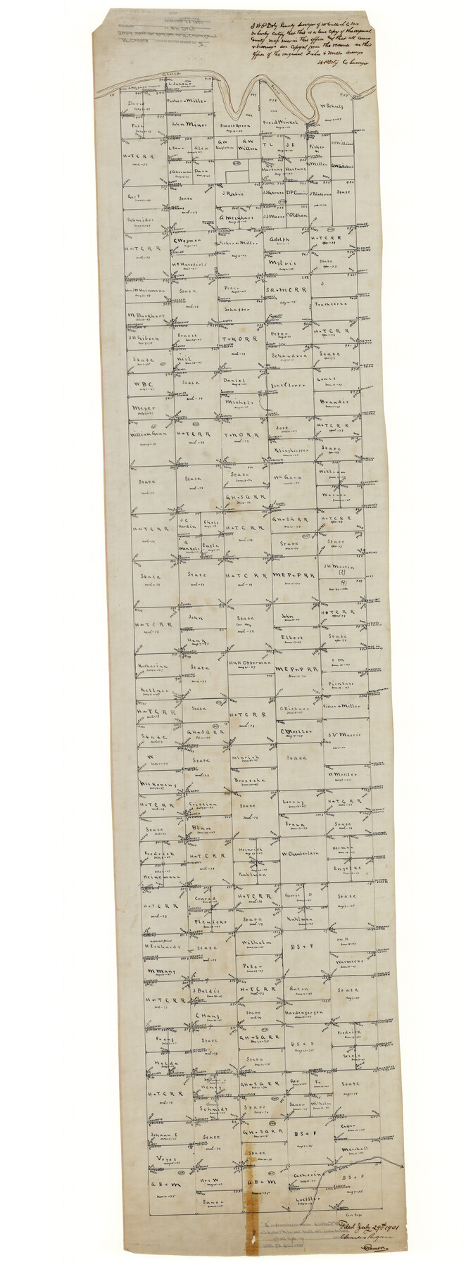
McCulloch County Rolled Sketch 2
Sketch Along East Line of McCulloch County, Texas
-
Map/Doc
9496
-
Collection
General Map Collection
-
Object Dates
7/29/1901 (File Date)
-
People and Organizations
W.P. Doty (Surveyor/Engineer)
-
Counties
McCulloch
-
Subjects
Surveying Rolled Sketch
-
Height x Width
81.6 x 30.0 inches
207.3 x 76.2 cm
-
Medium
linen, manuscript
Part of: General Map Collection
Eastland County Working Sketch 57

Print $20.00
- Digital $50.00
Eastland County Working Sketch 57
1985
Size 21.7 x 21.8 inches
Map/Doc 68838
Karnes County Rolled Sketch 1

Print $20.00
- Digital $50.00
Karnes County Rolled Sketch 1
1943
Size 27.5 x 25.7 inches
Map/Doc 6452
Titus County Sketch File 11

Print $4.00
- Digital $50.00
Titus County Sketch File 11
1872
Size 8.2 x 10.1 inches
Map/Doc 38150
Hockley County

Print $20.00
- Digital $50.00
Hockley County
1914
Size 25.8 x 22.4 inches
Map/Doc 66866
Donley County Sketch File B11

Print $4.00
- Digital $50.00
Donley County Sketch File B11
1952
Size 11.5 x 9.0 inches
Map/Doc 21274
Map of Chicago, Rock Island & Texas Railroad

Print $40.00
- Digital $50.00
Map of Chicago, Rock Island & Texas Railroad
1892
Size 23.9 x 122.0 inches
Map/Doc 64442
Foard County Sketch File 30

Print $6.00
- Digital $50.00
Foard County Sketch File 30
Size 9.1 x 8.2 inches
Map/Doc 22858
San Antonio, Texas Street Map

San Antonio, Texas Street Map
1997
Size 36.5 x 46.7 inches
Map/Doc 96868
Flight Mission No. DCL-6C, Frame 66, Kenedy County

Print $20.00
- Digital $50.00
Flight Mission No. DCL-6C, Frame 66, Kenedy County
1943
Size 18.7 x 22.4 inches
Map/Doc 85908
Hunt County Sketch File 30

Print $6.00
- Digital $50.00
Hunt County Sketch File 30
1862
Size 8.1 x 7.5 inches
Map/Doc 27132
San Patricio County NRC Article 33.136 Sketch 4A

Print $3.00
- Digital $50.00
San Patricio County NRC Article 33.136 Sketch 4A
Size 17.0 x 11.0 inches
Map/Doc 94696
Hamilton County Working Sketch 32

Print $20.00
- Digital $50.00
Hamilton County Working Sketch 32
1993
Size 26.3 x 34.3 inches
Map/Doc 63370
You may also like
Travis County Sketch File 11

Print $4.00
- Digital $50.00
Travis County Sketch File 11
1872
Size 11.4 x 8.8 inches
Map/Doc 38300
Bailey County Rolled Sketch 6

Print $20.00
- Digital $50.00
Bailey County Rolled Sketch 6
Size 17.4 x 12.9 inches
Map/Doc 5111
Trinity County Sketch File 14

Print $4.00
- Digital $50.00
Trinity County Sketch File 14
1862
Size 8.7 x 12.0 inches
Map/Doc 38540
Hispania Nova

Print $20.00
- Digital $50.00
Hispania Nova
1597
Size 12.0 x 14.9 inches
Map/Doc 94120
Flight Mission No. DAH-10M, Frame 42, Orange County

Print $20.00
- Digital $50.00
Flight Mission No. DAH-10M, Frame 42, Orange County
1953
Size 18.5 x 22.3 inches
Map/Doc 86877
Val Verde County Rolled Sketch 85

Print $20.00
- Digital $50.00
Val Verde County Rolled Sketch 85
2009
Size 25.4 x 38.0 inches
Map/Doc 89234
San Patricio County Sketch File 41

Print $4.00
- Digital $50.00
San Patricio County Sketch File 41
1842
Size 5.2 x 8.0 inches
Map/Doc 36238
Liberty County Sketch File 25

Print $8.00
- Digital $50.00
Liberty County Sketch File 25
1861
Size 8.0 x 10.0 inches
Map/Doc 29939
Flight Mission No. DAG-18K, Frame 71, Matagorda County

Print $20.00
- Digital $50.00
Flight Mission No. DAG-18K, Frame 71, Matagorda County
1952
Size 16.3 x 16.3 inches
Map/Doc 86364
Val Verde County Working Sketch 54

Print $20.00
- Digital $50.00
Val Verde County Working Sketch 54
1956
Size 24.0 x 20.4 inches
Map/Doc 72189
Map of the Passo Cavallo on the entrance into Matagorda Bay from the Gulf of Mexico

Print $20.00
- Digital $50.00
Map of the Passo Cavallo on the entrance into Matagorda Bay from the Gulf of Mexico
1853
Size 17.8 x 27.3 inches
Map/Doc 73012
Crosby County Sketch File 32

Print $20.00
- Digital $50.00
Crosby County Sketch File 32
1938
Size 23.2 x 31.8 inches
Map/Doc 11258