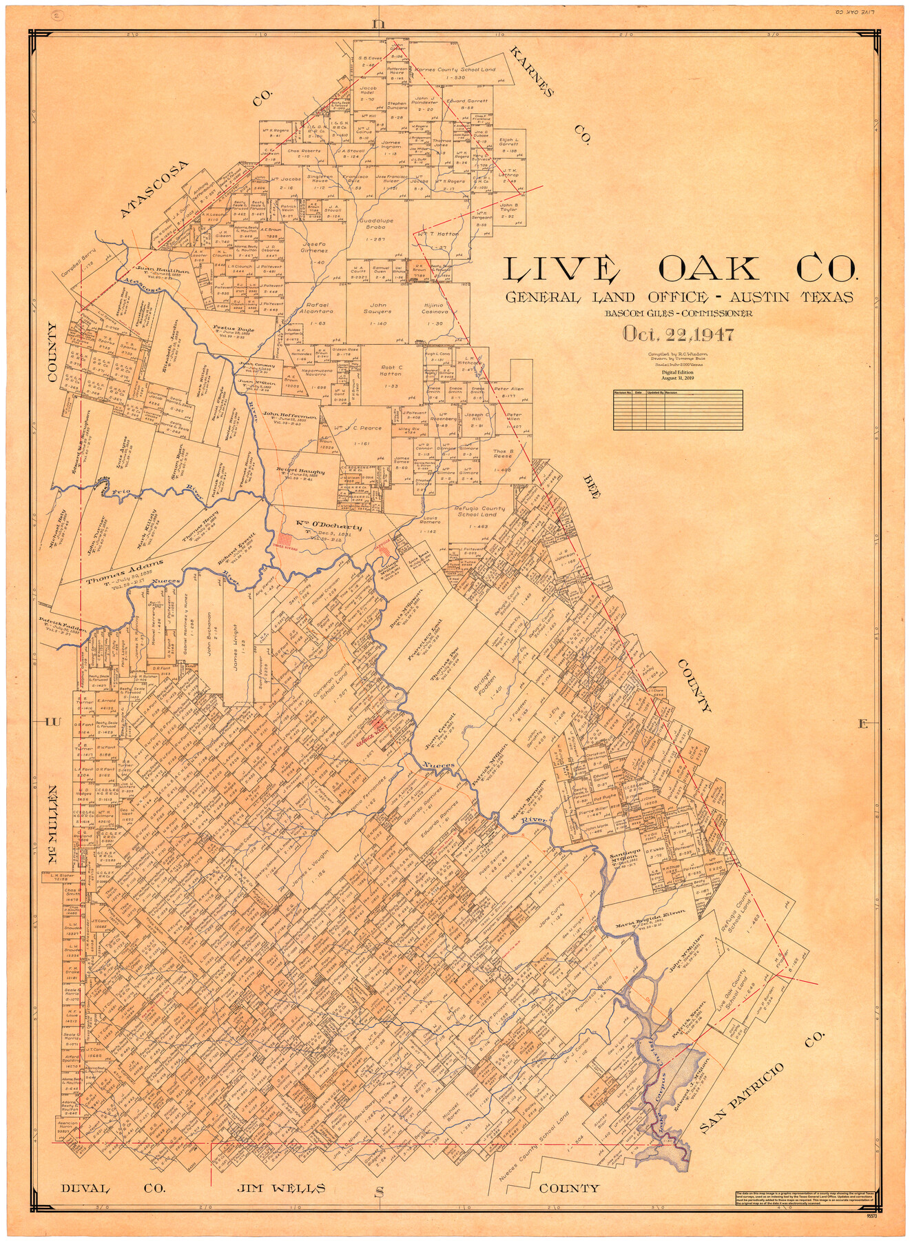
Live Oak Co.
General Land Office Official County Map
-
Map/Doc
95573
-
Collection
General Map Collection
-
Object Dates
2019/8/31 (Revision Date)
1947/10/22 (Creation Date)
-
People and Organizations
Cheyenne Betancourt (Draftsman)
Tommye Buie (Draftsman)
R.C. Wisdom (Compiler)
Bascom Giles (GLO Commissioner)
-
Counties
Live Oak
-
Subjects
County OCM
-
Height x Width
54.6 x 40.8 inches
138.7 x 103.6 cm
-
Medium
digital image
-
Scale
1" = 2000 varas
Part of: General Map Collection
Gaines County Rolled Sketch 34

Print $20.00
- Digital $50.00
Gaines County Rolled Sketch 34
2002
Size 20.1 x 22.3 inches
Map/Doc 77533
Flight Mission No. DIX-10P, Frame 76, Aransas County

Print $20.00
- Digital $50.00
Flight Mission No. DIX-10P, Frame 76, Aransas County
1956
Size 18.8 x 22.4 inches
Map/Doc 83937
Austin County Sketch File 14

Print $40.00
- Digital $50.00
Austin County Sketch File 14
Size 18.8 x 8.8 inches
Map/Doc 13880
Map of Armstrong County

Print $20.00
- Digital $50.00
Map of Armstrong County
1881
Size 25.8 x 19.9 inches
Map/Doc 3243
Bandera County Working Sketch 46

Print $20.00
- Digital $50.00
Bandera County Working Sketch 46
1981
Size 28.0 x 37.4 inches
Map/Doc 67642
Bosque County Sketch File 9

Print $6.00
- Digital $50.00
Bosque County Sketch File 9
1859
Size 4.3 x 4.7 inches
Map/Doc 14754
Trip to the West and Texas Comprising a Journey of Eight Thousand Miles, Through New-York, Michigan, Illinois, Missouri, Louisiana and Texas, in the Autumn and Winter of 1834-5. Interspersed with Anecdotes, Incidents and Observations. With a Brief Sketch

Trip to the West and Texas Comprising a Journey of Eight Thousand Miles, Through New-York, Michigan, Illinois, Missouri, Louisiana and Texas, in the Autumn and Winter of 1834-5. Interspersed with Anecdotes, Incidents and Observations. With a Brief Sketch
1836
Map/Doc 97078
Flight Mission No. CRK-8P, Frame 121, Refugio County

Print $20.00
- Digital $50.00
Flight Mission No. CRK-8P, Frame 121, Refugio County
1956
Size 18.3 x 22.2 inches
Map/Doc 86976
McLennan County Sketch File 4

Print $4.00
- Digital $50.00
McLennan County Sketch File 4
1852
Size 12.7 x 8.2 inches
Map/Doc 31235
El Paso County Working Sketch 37

Print $20.00
- Digital $50.00
El Paso County Working Sketch 37
1983
Size 28.2 x 24.8 inches
Map/Doc 69059
Texas for Tourists, a highway and reference map published by the Dallas Morning News for the Texas Almanac and State Industrial Guide

Texas for Tourists, a highway and reference map published by the Dallas Morning News for the Texas Almanac and State Industrial Guide
1936
Size 20.3 x 26.4 inches
Map/Doc 94294
Montgomery Co.

Print $40.00
- Digital $50.00
Montgomery Co.
1943
Size 44.4 x 54.1 inches
Map/Doc 73244
You may also like
Flight Mission No. CLL-1N, Frame 14, Willacy County

Print $20.00
- Digital $50.00
Flight Mission No. CLL-1N, Frame 14, Willacy County
1954
Size 18.2 x 22.1 inches
Map/Doc 87001
Zapata County Working Sketch 9

Print $20.00
- Digital $50.00
Zapata County Working Sketch 9
1951
Size 34.9 x 18.1 inches
Map/Doc 62060
Hardin County Sketch File 35

Print $24.00
- Digital $50.00
Hardin County Sketch File 35
Size 9.2 x 8.4 inches
Map/Doc 25175
San Augustine County Working Sketch 19

Print $20.00
- Digital $50.00
San Augustine County Working Sketch 19
1967
Size 22.9 x 30.6 inches
Map/Doc 63707
General Highway Map, Bexar County, Texas

Print $20.00
General Highway Map, Bexar County, Texas
1940
Size 18.4 x 25.1 inches
Map/Doc 76287
Schleicher County Rolled Sketch 7

Print $20.00
- Digital $50.00
Schleicher County Rolled Sketch 7
Size 32.5 x 37.9 inches
Map/Doc 9904
Somervell County

Print $20.00
- Digital $50.00
Somervell County
1884
Size 25.1 x 24.2 inches
Map/Doc 4042
Lipscomb County Sketch File 6

Print $20.00
- Digital $50.00
Lipscomb County Sketch File 6
1965
Size 19.4 x 26.1 inches
Map/Doc 12005
Cass County Working Sketch 6

Print $20.00
- Digital $50.00
Cass County Working Sketch 6
1936
Size 19.7 x 23.0 inches
Map/Doc 67909
Zavala County Sketch File 49

Print $10.00
- Digital $50.00
Zavala County Sketch File 49
1955
Size 14.5 x 9.1 inches
Map/Doc 41441
Runnels County Sketch File 5

Print $22.00
Runnels County Sketch File 5
Size 12.8 x 16.0 inches
Map/Doc 35436
Flight Mission No. DCL-6C, Frame 23, Kenedy County

Print $20.00
- Digital $50.00
Flight Mission No. DCL-6C, Frame 23, Kenedy County
1943
Size 18.7 x 22.3 inches
Map/Doc 85880