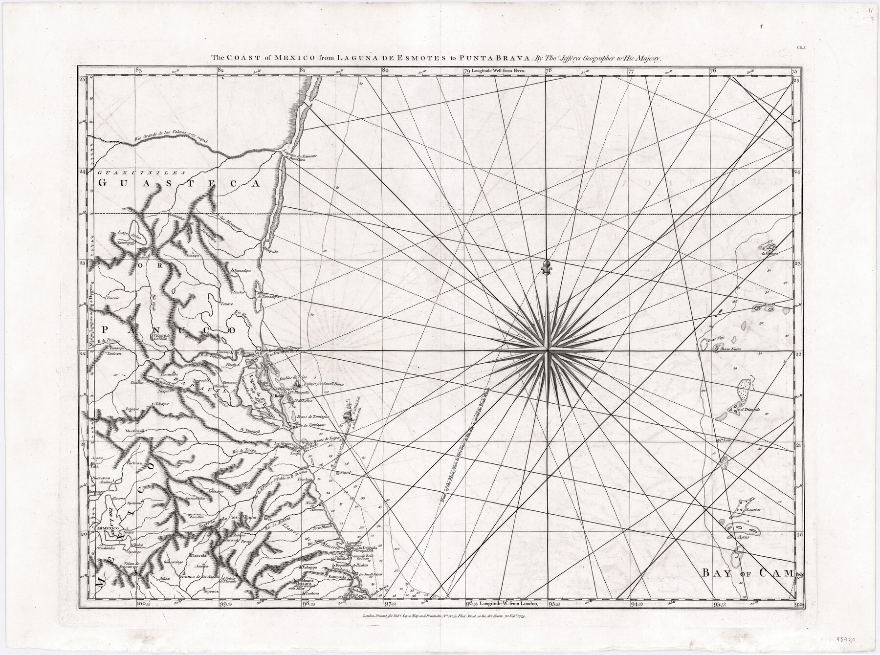
The Coast of Mexico from Laguna de Esmotes to Punta Brava
-
Map/Doc
95920
-
Collection
General Map Collection
-
Object Dates
2/20/1775 (Creation Date)
-
People and Organizations
Thomas Jefferys (Cartographer)
-
Subjects
Gulf of Mexico Mexico Nautical Charts
-
Height x Width
22.2 x 29.8 inches
56.4 x 75.7 cm
-
Medium
paper, etching/engraving/lithograph
Part of: General Map Collection
Williamson County Rolled Sketch 10

Print $20.00
- Digital $50.00
Williamson County Rolled Sketch 10
1975
Size 24.8 x 19.2 inches
Map/Doc 8267
Zapata County Working Sketch 13

Print $20.00
- Digital $50.00
Zapata County Working Sketch 13
1962
Size 28.7 x 29.6 inches
Map/Doc 62064
Map of Encinal County

Print $20.00
- Digital $50.00
Map of Encinal County
1878
Size 32.8 x 22.7 inches
Map/Doc 3514
Upton County Sketch File 6

Print $10.00
- Digital $50.00
Upton County Sketch File 6
1909
Size 11.3 x 8.6 inches
Map/Doc 38815
Presidio County Rolled Sketch 26

Print $20.00
- Digital $50.00
Presidio County Rolled Sketch 26
1886
Size 33.9 x 26.9 inches
Map/Doc 7333
Galveston Bay, Texas

Print $20.00
- Digital $50.00
Galveston Bay, Texas
1905
Size 24.8 x 18.5 inches
Map/Doc 65390
Sutton County Sketch File 62

Print $4.00
- Digital $50.00
Sutton County Sketch File 62
1959
Size 3.7 x 8.6 inches
Map/Doc 37564
Flight Mission No. BRA-3M, Frame 125, Jefferson County

Print $20.00
- Digital $50.00
Flight Mission No. BRA-3M, Frame 125, Jefferson County
1953
Size 18.6 x 21.5 inches
Map/Doc 85399
Flight Mission No. BRA-16M, Frame 57, Jefferson County

Print $20.00
- Digital $50.00
Flight Mission No. BRA-16M, Frame 57, Jefferson County
1953
Size 18.3 x 22.5 inches
Map/Doc 85674
Liberty County Sketch File 63

Print $138.00
- Digital $50.00
Liberty County Sketch File 63
1983
Size 11.1 x 8.8 inches
Map/Doc 30087
Webb County Sketch File 9b

Print $20.00
- Digital $50.00
Webb County Sketch File 9b
1930
Size 15.9 x 16.5 inches
Map/Doc 12620
Flight Mission No. DAH-9M, Frame 157, Orange County

Print $20.00
- Digital $50.00
Flight Mission No. DAH-9M, Frame 157, Orange County
1953
Size 18.5 x 22.5 inches
Map/Doc 86856
You may also like
Map of Chambers County

Print $20.00
- Digital $50.00
Map of Chambers County
1896
Size 22.2 x 23.3 inches
Map/Doc 3385
Angelina County Sketch File 18b

Print $40.00
- Digital $50.00
Angelina County Sketch File 18b
Size 12.6 x 16.2 inches
Map/Doc 13032
City of Port Aransas

Print $40.00
- Digital $50.00
City of Port Aransas
1990
Size 25.2 x 53.3 inches
Map/Doc 3213
Hays County Sketch File 30

Print $12.00
- Digital $50.00
Hays County Sketch File 30
1938
Size 14.3 x 9.0 inches
Map/Doc 26255
Baylor County Sketch File 15

Print $6.00
- Digital $50.00
Baylor County Sketch File 15
1879
Size 13.0 x 8.4 inches
Map/Doc 14183
Hardeman County Sketch File 12

Print $4.00
- Digital $50.00
Hardeman County Sketch File 12
Size 12.8 x 8.3 inches
Map/Doc 25020
[Pencil sketch around the Fred Mohler survey 19]
![92994, [Pencil sketch around the Fred Mohler survey 19], Twichell Survey Records](https://historictexasmaps.com/wmedia_w700/maps/92994-1.tif.jpg)
Print $3.00
- Digital $50.00
[Pencil sketch around the Fred Mohler survey 19]
Size 14.1 x 10.4 inches
Map/Doc 92994
Lynn County Rolled Sketch 15

Print $20.00
- Digital $50.00
Lynn County Rolled Sketch 15
1986
Size 36.4 x 24.5 inches
Map/Doc 6651
Coryell County Working Sketch 21

Print $20.00
- Digital $50.00
Coryell County Working Sketch 21
1973
Size 37.0 x 37.8 inches
Map/Doc 68228
Leon County Working Sketch 52a

Print $20.00
- Digital $50.00
Leon County Working Sketch 52a
1982
Size 35.1 x 42.8 inches
Map/Doc 70451
Mills County Sketch File 23

Print $4.00
- Digital $50.00
Mills County Sketch File 23
Size 12.4 x 9.2 inches
Map/Doc 31672
Pecos County Boundary File 69a

Print $40.00
- Digital $50.00
Pecos County Boundary File 69a
Size 8.4 x 9.7 inches
Map/Doc 57901