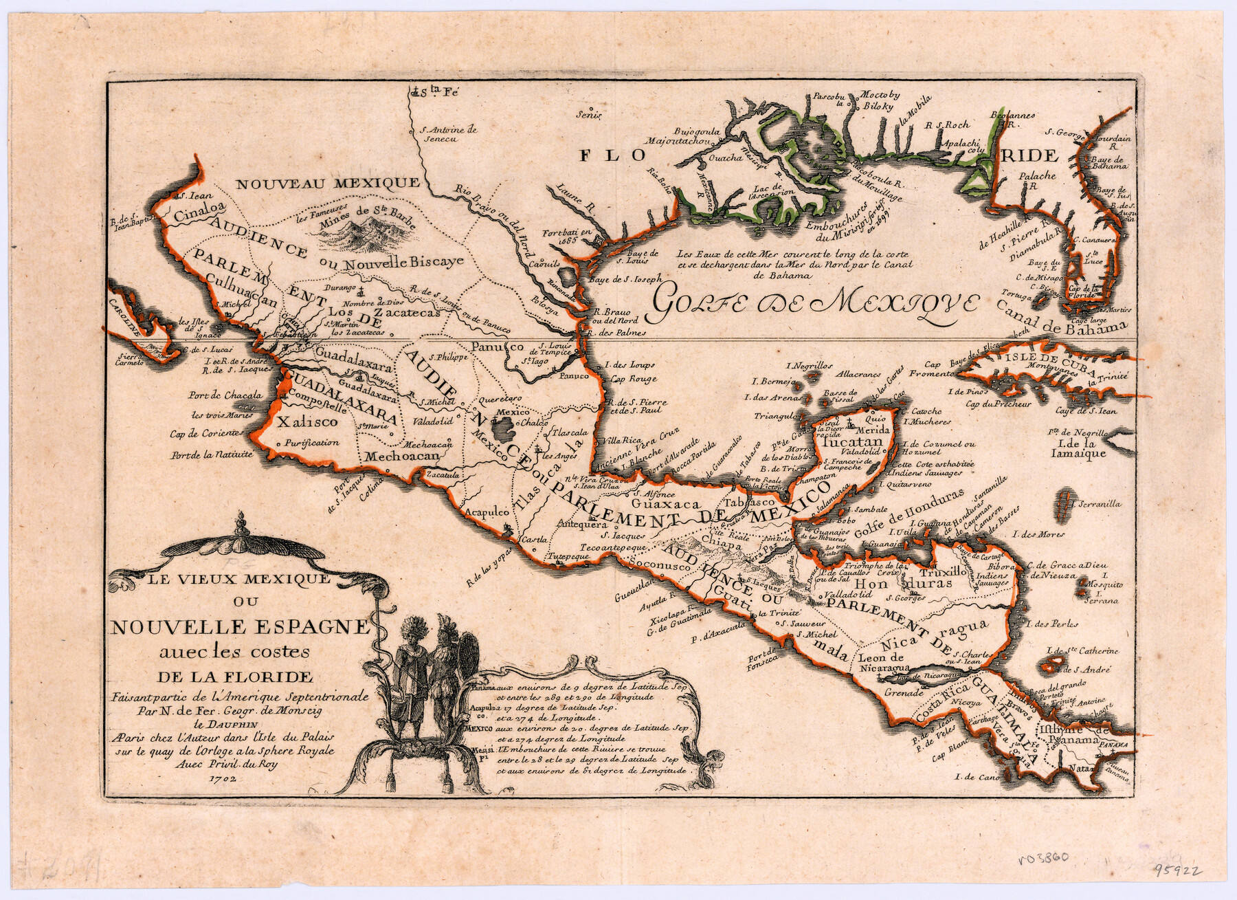
Le Vieux Mexique ou Nouvelle Espagne avec les costes de la Floride faisant partie de l'Amerique Septentrionale
-
Map/Doc
95922
-
Collection
General Map Collection
-
Object Dates
1702 (Creation Date)
-
People and Organizations
Nicolas de Fer (Cartographer)
-
Subjects
Gulf of Mexico Mexico
-
Height x Width
11.2 x 15.5 inches
28.5 x 39.4 cm
-
Medium
paper, etching/engraving/lithograph
Part of: General Map Collection
Harbor Pass and Bar at Brazos Santiago, Texas

Print $20.00
- Digital $50.00
Harbor Pass and Bar at Brazos Santiago, Texas
1879
Size 18.2 x 27.2 inches
Map/Doc 73001
Newton County Working Sketch 27

Print $20.00
- Digital $50.00
Newton County Working Sketch 27
1953
Size 25.9 x 30.0 inches
Map/Doc 71273
Pecos County Sketch File 38

Print $4.00
- Digital $50.00
Pecos County Sketch File 38
1895
Size 11.3 x 8.8 inches
Map/Doc 33720
Flight Mission No. BQR-9K, Frame 9, Brazoria County

Print $20.00
- Digital $50.00
Flight Mission No. BQR-9K, Frame 9, Brazoria County
1952
Size 18.6 x 22.3 inches
Map/Doc 84038
Crockett County Rolled Sketch 67

Print $20.00
- Digital $50.00
Crockett County Rolled Sketch 67
1948
Size 34.2 x 21.7 inches
Map/Doc 5610
Geodetic positions of authentic boundary mounds, established by Louisiana Geodetic Survey traverse

Print $4.00
- Digital $50.00
Geodetic positions of authentic boundary mounds, established by Louisiana Geodetic Survey traverse
Size 28.8 x 28.7 inches
Map/Doc 1734
Presidio County Sketch File 118

Print $16.00
- Digital $50.00
Presidio County Sketch File 118
Size 14.3 x 8.9 inches
Map/Doc 34919
Cherokee County Sketch File 18

Print $4.00
- Digital $50.00
Cherokee County Sketch File 18
1870
Size 10.2 x 8.1 inches
Map/Doc 18159
Walker County Working Sketch 4

Print $20.00
- Digital $50.00
Walker County Working Sketch 4
1934
Size 34.9 x 29.7 inches
Map/Doc 72284
Lamb County Sketch File 9

Print $4.00
- Digital $50.00
Lamb County Sketch File 9
1910
Size 10.9 x 7.2 inches
Map/Doc 29358
Right of Way & Track Map, San Antonio & Aransas Pass Railway Co.

Print $40.00
- Digital $50.00
Right of Way & Track Map, San Antonio & Aransas Pass Railway Co.
1919
Size 25.0 x 56.7 inches
Map/Doc 64215
Flight Mission No. CRC-4R, Frame 108, Chambers County

Print $20.00
- Digital $50.00
Flight Mission No. CRC-4R, Frame 108, Chambers County
1956
Size 18.7 x 22.4 inches
Map/Doc 84905
You may also like
[Surveys in the Bexar District along the San Antonio River showing the position of the missions]
![125, [Surveys in the Bexar District along the San Antonio River showing the position of the missions], General Map Collection](https://historictexasmaps.com/wmedia_w700/maps/125.tif.jpg)
Print $3.00
- Digital $50.00
[Surveys in the Bexar District along the San Antonio River showing the position of the missions]
1841
Size 11.2 x 16.0 inches
Map/Doc 125
Jasper County Sketch File 12a

Print $16.00
- Digital $50.00
Jasper County Sketch File 12a
1881
Size 13.0 x 8.4 inches
Map/Doc 27794
[Missouri, Kansas & Texas Line Map through Bastrop County]
![64029, [Missouri, Kansas & Texas Line Map through Bastrop County], General Map Collection](https://historictexasmaps.com/wmedia_w700/maps/64029.tif.jpg)
Print $40.00
- Digital $50.00
[Missouri, Kansas & Texas Line Map through Bastrop County]
1916
Size 25.8 x 122.6 inches
Map/Doc 64029
Eubank Farm N/2 of NE/4 Section 3, Block D3

Print $20.00
- Digital $50.00
Eubank Farm N/2 of NE/4 Section 3, Block D3
Size 20.9 x 14.0 inches
Map/Doc 92336
Reeves County Rolled Sketch 34

Print $20.00
- Digital $50.00
Reeves County Rolled Sketch 34
Size 35.4 x 24.1 inches
Map/Doc 78490
Brazos River, Ball Hill Sheet/Big Creek

Print $6.00
- Digital $50.00
Brazos River, Ball Hill Sheet/Big Creek
1926
Size 34.3 x 30.0 inches
Map/Doc 65281
Flight Mission No. BRE-2P, Frame 20, Nueces County

Print $20.00
- Digital $50.00
Flight Mission No. BRE-2P, Frame 20, Nueces County
1956
Size 17.1 x 19.8 inches
Map/Doc 86729
Montgomery County Working Sketch 16

Print $20.00
- Digital $50.00
Montgomery County Working Sketch 16
1934
Size 28.9 x 33.7 inches
Map/Doc 71123
Winkler County Sketch File 10

Print $4.00
- Digital $50.00
Winkler County Sketch File 10
1910
Size 9.1 x 8.3 inches
Map/Doc 40486
Edwards County Working Sketch 101

Print $20.00
- Digital $50.00
Edwards County Working Sketch 101
1971
Size 36.9 x 38.8 inches
Map/Doc 68977
Oldham County Sketch File 20

Print $6.00
- Digital $50.00
Oldham County Sketch File 20
1916
Size 11.1 x 8.5 inches
Map/Doc 33275
Goliad County Working Sketch 9

Print $20.00
- Digital $50.00
Goliad County Working Sketch 9
1938
Size 19.3 x 27.6 inches
Map/Doc 63199