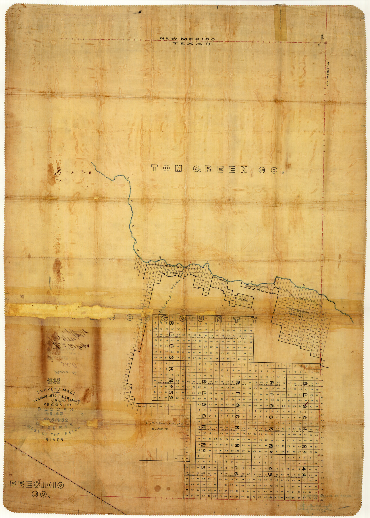
Pecos County Rolled Sketch 6
Map of surveys made for the Texas & Pacific Railway Co. in Pecos Co. Blocks 48, 49, 50, 51, & 52 reserve west of the Pecos River
Pecos County Sketch File 6
-
Map/Doc
9680
-
Collection
General Map Collection
-
Object Dates
1877/7/12 (File Date)
-
Counties
Pecos Reeves
-
Subjects
Surveying Rolled Sketch
-
Height x Width
43.6 x 31.2 inches
110.7 x 79.2 cm
-
Medium
paper, manuscript
Part of: General Map Collection
DeWitt County Sketch File 5

Print $4.00
- Digital $50.00
DeWitt County Sketch File 5
1872
Size 13.0 x 8.3 inches
Map/Doc 20803
Atascosa County Sketch File 16

Print $4.00
- Digital $50.00
Atascosa County Sketch File 16
1877
Size 12.2 x 7.9 inches
Map/Doc 13779
Uvalde County Rolled Sketch 17

Print $20.00
- Digital $50.00
Uvalde County Rolled Sketch 17
Size 26.7 x 22.2 inches
Map/Doc 8101
Val Verde County Sketch File 30

Print $8.00
- Digital $50.00
Val Verde County Sketch File 30
1933
Size 11.5 x 8.8 inches
Map/Doc 39236
Goliad County Sketch File 14

Print $4.00
- Digital $50.00
Goliad County Sketch File 14
1878
Size 8.6 x 11.4 inches
Map/Doc 24243
Plat of a survey of the North part of section 16, Block 362, Martha McBride, Presidio County, Texas

Print $20.00
- Digital $50.00
Plat of a survey of the North part of section 16, Block 362, Martha McBride, Presidio County, Texas
1989
Size 24.3 x 36.1 inches
Map/Doc 60523
Live Oak County

Print $40.00
- Digital $50.00
Live Oak County
1899
Size 52.1 x 37.5 inches
Map/Doc 78423
Colorado County Sketch File 33

Print $44.00
- Digital $50.00
Colorado County Sketch File 33
1847
Size 13.2 x 16.2 inches
Map/Doc 18988
Map of Eagle Lake

Print $20.00
- Digital $50.00
Map of Eagle Lake
1938
Size 13.0 x 17.0 inches
Map/Doc 2208
Lee County Rolled Sketch 1

Print $40.00
- Digital $50.00
Lee County Rolled Sketch 1
1939
Size 71.0 x 42.4 inches
Map/Doc 10739
Somervell County

Print $20.00
- Digital $50.00
Somervell County
1941
Size 28.1 x 26.1 inches
Map/Doc 73291
Frio County Rolled Sketch 21

Print $20.00
- Digital $50.00
Frio County Rolled Sketch 21
1961
Size 43.8 x 27.7 inches
Map/Doc 8911
You may also like
The Republic County of Red River. December 17, 1840

Print $20.00
The Republic County of Red River. December 17, 1840
2020
Size 17.4 x 21.7 inches
Map/Doc 96252
![91233, [Block R], Twichell Survey Records](https://historictexasmaps.com/wmedia_w700/maps/91233-1.tif.jpg)
[Aerial photograph from Carancahua Bend of Caney Creek to Cedar Lake]
![78639, [Aerial photograph from Carancahua Bend of Caney Creek to Cedar Lake], General Map Collection](https://historictexasmaps.com/wmedia_w700/maps/78639.tif.jpg)
Print $20.00
- Digital $50.00
[Aerial photograph from Carancahua Bend of Caney Creek to Cedar Lake]
1991
Size 24.4 x 34.0 inches
Map/Doc 78639
Montgomery County, Texas

Print $20.00
- Digital $50.00
Montgomery County, Texas
1880
Size 24.6 x 27.6 inches
Map/Doc 582
Baylor County Boundary File 11

Print $26.00
- Digital $50.00
Baylor County Boundary File 11
Size 11.1 x 8.7 inches
Map/Doc 50419
Presidio County Working Sketch 49

Print $20.00
- Digital $50.00
Presidio County Working Sketch 49
1951
Size 34.5 x 47.0 inches
Map/Doc 71726
Matagorda Bay Including Lavaca and Tres Palacios Bays

Print $20.00
- Digital $50.00
Matagorda Bay Including Lavaca and Tres Palacios Bays
1992
Size 37.0 x 47.8 inches
Map/Doc 73366
Duval County Sketch File 75

Print $20.00
- Digital $50.00
Duval County Sketch File 75
1935
Size 18.0 x 28.5 inches
Map/Doc 11409
[F. W. & D. C. Ry. Co. Alignment and Right of Way Map, Clay County]
![64722, [F. W. & D. C. Ry. Co. Alignment and Right of Way Map, Clay County], General Map Collection](https://historictexasmaps.com/wmedia_w700/maps/64722-1.tif.jpg)
Print $20.00
- Digital $50.00
[F. W. & D. C. Ry. Co. Alignment and Right of Way Map, Clay County]
1927
Size 18.7 x 11.7 inches
Map/Doc 64722
Denton County Working Sketch 38

Print $20.00
- Digital $50.00
Denton County Working Sketch 38
2010
Size 23.4 x 29.5 inches
Map/Doc 89571
Harbor Pass and Bar at Brazos Santiago, Texas

Print $20.00
- Digital $50.00
Harbor Pass and Bar at Brazos Santiago, Texas
1871
Size 18.2 x 26.8 inches
Map/Doc 72983
Falls County Working Sketch 1

Print $20.00
- Digital $50.00
Falls County Working Sketch 1
1922
Size 23.0 x 33.1 inches
Map/Doc 69176