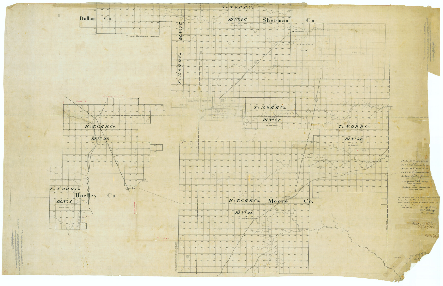
Sherman County Rolled Sketch 2
Blocks no. 44, 47 1/2, 48, & 50 of the H. & T. C. R.R. Company's surveys and Blocks no. 1, 1T, 2T, 3T, & 7T of the T. & N. O. R.R. Company's surveys in Dallam, Hartley, Sherman, and Moore Cos.
-
Map/Doc
9927
-
Collection
General Map Collection
-
Object Dates
1888 (Survey Date)
1888/11/24 (Creation Date)
1889/2/25 (File Date)
-
People and Organizations
Geo. Spiller (Surveyor/Engineer)
W.S. Mabry (Surveyor/Engineer)
-
Counties
Sherman Dallam Hartley Moore
-
Subjects
Surveying Rolled Sketch
-
Height x Width
43.9 x 67.9 inches
111.5 x 172.5 cm
-
Medium
linen, manuscript
-
Scale
1" = 2000 varas
Part of: General Map Collection
Map of Bexar County

Print $40.00
- Digital $50.00
Map of Bexar County
1845
Size 49.0 x 46.5 inches
Map/Doc 87236
Bee County Sketch File 24

Print $8.00
- Digital $50.00
Bee County Sketch File 24
1879
Size 10.2 x 8.3 inches
Map/Doc 14322
Comal County Working Sketch 9

Print $20.00
- Digital $50.00
Comal County Working Sketch 9
1972
Size 29.0 x 30.4 inches
Map/Doc 68175
DeWitt County Sketch File 7

Print $2.00
- Digital $50.00
DeWitt County Sketch File 7
1876
Size 11.3 x 9.0 inches
Map/Doc 20817
Montgomery County Working Sketch 70

Print $20.00
- Digital $50.00
Montgomery County Working Sketch 70
1973
Size 41.3 x 31.7 inches
Map/Doc 71177
Pecos County Working Sketch 40

Print $20.00
- Digital $50.00
Pecos County Working Sketch 40
1941
Size 29.9 x 39.7 inches
Map/Doc 71512
Boundary Between the United States & Mexico Agreed Upon by the Joint Commission under the Treaty of Guadalupe Hidalgo

Print $4.00
- Digital $50.00
Boundary Between the United States & Mexico Agreed Upon by the Joint Commission under the Treaty of Guadalupe Hidalgo
1853
Size 24.9 x 18.1 inches
Map/Doc 65393
Duval County Sketch File 4b

Print $4.00
- Digital $50.00
Duval County Sketch File 4b
1874
Size 10.4 x 7.8 inches
Map/Doc 21282
Galveston County NRC Article 33.136 Sketch 73

Print $28.00
- Digital $50.00
Galveston County NRC Article 33.136 Sketch 73
2013
Size 31.7 x 24.0 inches
Map/Doc 94995
Aransas County Rolled Sketch 8

Print $20.00
- Digital $50.00
Aransas County Rolled Sketch 8
Size 41.0 x 43.5 inches
Map/Doc 8408
Il Cuscho Citta Principale Della Provincia del Peru

Print $20.00
- Digital $50.00
Il Cuscho Citta Principale Della Provincia del Peru
1592
Size 12.3 x 15.4 inches
Map/Doc 97026
Houston County Working Sketch 2

Print $20.00
- Digital $50.00
Houston County Working Sketch 2
Size 16.1 x 18.6 inches
Map/Doc 66232
You may also like
[Rio Grande & Eagle Pass - Stockdale to Cuero]
![64047, [Rio Grande & Eagle Pass - Stockdale to Cuero], General Map Collection](https://historictexasmaps.com/wmedia_w700/maps/64047.tif.jpg)
Print $40.00
- Digital $50.00
[Rio Grande & Eagle Pass - Stockdale to Cuero]
Size 20.6 x 121.5 inches
Map/Doc 64047
Map of Dallas County

Print $20.00
- Digital $50.00
Map of Dallas County
1871
Size 22.1 x 18.7 inches
Map/Doc 3463
Largo Distancia Colonia Located on S. Half of SW Quarter Section 8, Block A

Print $20.00
- Digital $50.00
Largo Distancia Colonia Located on S. Half of SW Quarter Section 8, Block A
Size 20.3 x 13.6 inches
Map/Doc 92765
Bexar County Sketch File 58a

Print $4.00
- Digital $50.00
Bexar County Sketch File 58a
1847
Size 10.2 x 8.2 inches
Map/Doc 14574
Blanco County Sketch File 30

Print $5.00
- Digital $50.00
Blanco County Sketch File 30
Size 9.1 x 10.6 inches
Map/Doc 14627
Dickens County Sketch File 16

Print $4.00
- Digital $50.00
Dickens County Sketch File 16
Size 7.4 x 11.1 inches
Map/Doc 20975
Comanche County Sketch File 28

Print $6.00
- Digital $50.00
Comanche County Sketch File 28
Size 6.1 x 11.7 inches
Map/Doc 19117
A sketch of the San Antonio River collected from the Land Office surveys

Print $20.00
- Digital $50.00
A sketch of the San Antonio River collected from the Land Office surveys
1853
Size 27.2 x 16.3 inches
Map/Doc 73010
Red River County Working Sketch 63

Print $20.00
- Digital $50.00
Red River County Working Sketch 63
1973
Size 43.6 x 37.0 inches
Map/Doc 72046
Liberty County Sketch File AX

Print $10.00
- Digital $50.00
Liberty County Sketch File AX
1899
Size 14.1 x 8.5 inches
Map/Doc 30061
[River Secs. 68 1/2-73, Pt. Blk. GG]
![90478, [River Secs. 68 1/2-73, Pt. Blk. GG], Twichell Survey Records](https://historictexasmaps.com/wmedia_w700/maps/90478-1.tif.jpg)
Print $20.00
- Digital $50.00
[River Secs. 68 1/2-73, Pt. Blk. GG]
Size 27.6 x 20.7 inches
Map/Doc 90478
Chambers County Rolled Sketch 14

Print $20.00
- Digital $50.00
Chambers County Rolled Sketch 14
1935
Size 33.3 x 41.7 inches
Map/Doc 8616