Stonewall County Rolled Sketch 29
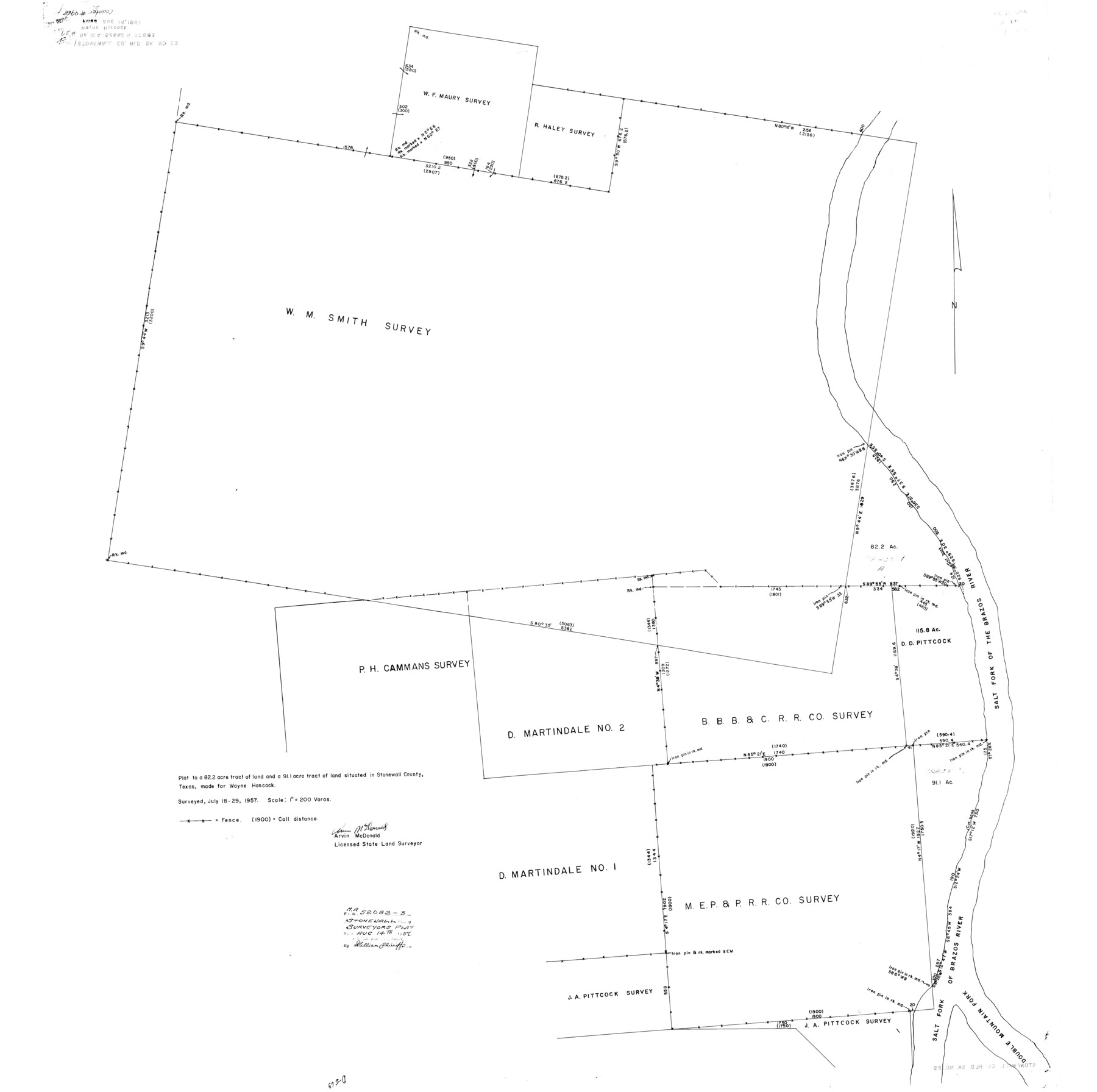
Plat to a 82.2 acre tract of land and a 91.1 acre tract of land situated in Stonewall County, Texas, made for Wayne Hancock
-
Map/Doc
9968
-
Collection
General Map Collection
-
Object Dates
1957/8/14 (File Date)
1957/7/29 (Survey Date)
-
People and Organizations
Arvin McDonald (Surveyor/Engineer)
-
Counties
Stonewall
-
Subjects
Surveying Rolled Sketch
-
Height x Width
39.8 x 40.0 inches
101.1 x 101.6 cm
-
Scale
1" = 200 varas
Part of: General Map Collection
McCulloch County Working Sketch 15

Print $20.00
- Digital $50.00
McCulloch County Working Sketch 15
1994
Size 33.2 x 34.0 inches
Map/Doc 70690
Swisher County Sketch File 2b

Print $4.00
- Digital $50.00
Swisher County Sketch File 2b
1910
Size 11.2 x 8.7 inches
Map/Doc 37616
Childress County Sketch File 18a

Print $4.00
- Digital $50.00
Childress County Sketch File 18a
1935
Size 11.3 x 7.1 inches
Map/Doc 18364
Stephens County Boundary File 81

Print $44.00
- Digital $50.00
Stephens County Boundary File 81
Size 9.2 x 3.8 inches
Map/Doc 58906
Township 11 North Range 16 West, South Western District, Louisiana

Print $20.00
- Digital $50.00
Township 11 North Range 16 West, South Western District, Louisiana
1834
Size 19.7 x 24.7 inches
Map/Doc 65869
Dawson County Boundary File 3 (1)

Print $40.00
- Digital $50.00
Dawson County Boundary File 3 (1)
Size 11.1 x 35.8 inches
Map/Doc 52365
Hudspeth County Sketch File 50

Print $20.00
- Digital $50.00
Hudspeth County Sketch File 50
Size 11.2 x 8.7 inches
Map/Doc 42948
Gaines County Rolled Sketch 19

Print $20.00
- Digital $50.00
Gaines County Rolled Sketch 19
1953
Size 22.2 x 17.2 inches
Map/Doc 5935
Jeff Davis County Working Sketch 32

Print $40.00
- Digital $50.00
Jeff Davis County Working Sketch 32
1975
Size 66.7 x 43.7 inches
Map/Doc 66527
Motley County Sketch File 1 (N)

Print $4.00
- Digital $50.00
Motley County Sketch File 1 (N)
Size 11.4 x 6.7 inches
Map/Doc 31994
Harris County Working Sketch 86

Print $20.00
- Digital $50.00
Harris County Working Sketch 86
1972
Size 42.7 x 31.9 inches
Map/Doc 65978
Map of Collingsworth County

Print $20.00
- Digital $50.00
Map of Collingsworth County
1899
Size 41.1 x 38.6 inches
Map/Doc 4738
You may also like
Hale County Working Sketch 6

Print $40.00
- Digital $50.00
Hale County Working Sketch 6
1963
Size 68.9 x 38.8 inches
Map/Doc 63326
Mustang Island, Nueces County, Texas

Print $20.00
- Digital $50.00
Mustang Island, Nueces County, Texas
1978
Size 40.7 x 36.2 inches
Map/Doc 2500
[F. W. & D. C. Ry. Co. Alignment and Right of Way Map, Clay County]
![64747, [F. W. & D. C. Ry. Co. Alignment and Right of Way Map, Clay County], General Map Collection](https://historictexasmaps.com/wmedia_w700/maps/64747-GC.tif.jpg)
Print $20.00
- Digital $50.00
[F. W. & D. C. Ry. Co. Alignment and Right of Way Map, Clay County]
1927
Size 18.7 x 11.9 inches
Map/Doc 64747
Grayson County Boundary File 35

Print $42.00
- Digital $50.00
Grayson County Boundary File 35
Size 9.3 x 7.9 inches
Map/Doc 53961
Texas & Pacific Ry Reserve west of the Pecos River

Print $40.00
- Digital $50.00
Texas & Pacific Ry Reserve west of the Pecos River
1880
Size 43.9 x 90.6 inches
Map/Doc 3047
Rio Grande, Mercedes and La Feria Sheet

Print $20.00
- Digital $50.00
Rio Grande, Mercedes and La Feria Sheet
1937
Size 37.3 x 37.2 inches
Map/Doc 65126
Jefferson County Rolled Sketch 62

Print $40.00
- Digital $50.00
Jefferson County Rolled Sketch 62
1974
Size 78.4 x 43.1 inches
Map/Doc 9318
Maps of Gulf Intracoastal Waterway, Texas - Sabine River to the Rio Grande and connecting waterways including ship channels

Print $20.00
- Digital $50.00
Maps of Gulf Intracoastal Waterway, Texas - Sabine River to the Rio Grande and connecting waterways including ship channels
1966
Size 14.5 x 22.2 inches
Map/Doc 61964
Dawson County Sketch File 21

Print $20.00
- Digital $50.00
Dawson County Sketch File 21
1953
Size 12.2 x 24.5 inches
Map/Doc 11297
El Paso County Sketch File 32

Print $8.00
- Digital $50.00
El Paso County Sketch File 32
1983
Size 14.3 x 8.9 inches
Map/Doc 22124
Henderson County Sketch File 24

Print $20.00
- Digital $50.00
Henderson County Sketch File 24
1974
Size 27.4 x 24.1 inches
Map/Doc 11759
E. N. Gustafson's survey of Northern Portion of Lake Austin, Matagorda Co., TX

Print $40.00
- Digital $50.00
E. N. Gustafson's survey of Northern Portion of Lake Austin, Matagorda Co., TX
1926
Size 43.0 x 52.5 inches
Map/Doc 2068