Deaf Smith County Working Sketch 6

Print $20.00
- Digital $50.00
Deaf Smith County Working Sketch 6
2019
Size: 36.5 x 24.5 inches
95408
Castro County Sketch File 18

Print $20.00
- Digital $50.00
Castro County Sketch File 18
1988
Size: 40.4 x 37.7 inches
10330
Deaf Smith County Sketch File 8

Print $20.00
- Digital $50.00
Deaf Smith County Sketch File 8
1988
Size: 24.3 x 32.9 inches
11304
Deaf Smith County Working Sketch 4

Print $40.00
- Digital $50.00
Deaf Smith County Working Sketch 4
1983
Size: 37.0 x 52.4 inches
68644
Deaf Smith County Working Sketch 5

Print $40.00
- Digital $50.00
Deaf Smith County Working Sketch 5
1983
Size: 37.0 x 53.9 inches
68645
Oldham County Working Sketch 8

Print $20.00
- Digital $50.00
Oldham County Working Sketch 8
1982
Size: 33.4 x 35.8 inches
71330
Oldham County Working Sketch 9

Print $20.00
- Digital $50.00
Oldham County Working Sketch 9
1982
Size: 33.3 x 37.2 inches
71331
Deaf Smith County Rolled Sketch 2

Print $20.00
- Digital $50.00
Deaf Smith County Rolled Sketch 2
1976
Size: 42.7 x 14.4 inches
5699
Deaf Smith County Rolled Sketch 1

Print $20.00
- Digital $50.00
Deaf Smith County Rolled Sketch 1
1965
Size: 24.8 x 25.9 inches
5698
Castro County Working Sketch 9

Print $20.00
- Digital $50.00
Castro County Working Sketch 9
1965
Size: 47.1 x 42.7 inches
68646
Castro County Rolled Sketch 14

Print $20.00
- Digital $50.00
Castro County Rolled Sketch 14
1965
Size: 47.6 x 43.5 inches
8608
General Highway Map, Deaf Smith County, Texas

Print $20.00
General Highway Map, Deaf Smith County, Texas
1961
Size: 24.5 x 18.1 inches
79437
General Highway Map, Deaf Smith County, Texas

Print $20.00
General Highway Map, Deaf Smith County, Texas
1961
Size: 25.0 x 18.3 inches
79438
Deaf Smith County Working Sketch 3

Print $40.00
- Digital $50.00
Deaf Smith County Working Sketch 3
1951
Size: 61.4 x 22.3 inches
68643
General Highway Map, Oldham County, Deaf Smith County, Texas

Print $20.00
General Highway Map, Oldham County, Deaf Smith County, Texas
1940
Size: 18.3 x 25.2 inches
79072
Randall County Working Sketch 3

Print $40.00
- Digital $50.00
Randall County Working Sketch 3
1934
Size: 48.8 x 42.5 inches
71840
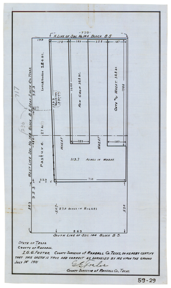
[Plat of West Part of Section 144, Block B5]
Print $2.00
- Digital $50.00
[Plat of West Part of Section 144, Block B5]
1931
Size: 8.7 x 14.3 inches
90602
Randall County Sketch File 3

Print $20.00
- Digital $50.00
Randall County Sketch File 3
1930
Size: 23.8 x 16.3 inches
12206
Deaf Smith County

Print $40.00
- Digital $50.00
Deaf Smith County
1926
Size: 41.4 x 54.3 inches
1816
Deaf Smith County

Print $40.00
- Digital $50.00
Deaf Smith County
1926
Size: 39.0 x 50.5 inches
73128
Deaf Smith County

Print $20.00
- Digital $50.00
Deaf Smith County
1926
Size: 32.9 x 41.3 inches
77260
Deaf Smith County

Print $40.00
- Digital $50.00
Deaf Smith County
1926
Size: 38.5 x 50.3 inches
95477
Deaf Smith County Working Sketch Graphic Index

Print $40.00
- Digital $50.00
Deaf Smith County Working Sketch Graphic Index
1926
Size: 40.1 x 52.6 inches
76519
Deaf Smith County Working Sketch 2

Print $20.00
- Digital $50.00
Deaf Smith County Working Sketch 2
1926
Size: 42.3 x 33.1 inches
68642
Deaf Smith County

Print $40.00
- Digital $50.00
Deaf Smith County
1922
Size: 55.0 x 43.9 inches
89768
Deaf Smith County Working Sketch 1

Print $20.00
- Digital $50.00
Deaf Smith County Working Sketch 1
1919
Size: 27.3 x 14.7 inches
68641
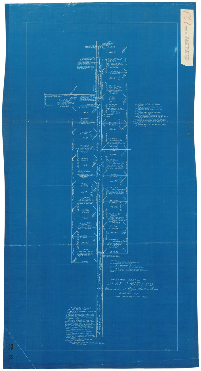
Working Sketch in Deaf Smith County [east of Block K3]
Print $20.00
- Digital $50.00
Working Sketch in Deaf Smith County [east of Block K3]
1919
Size: 15.2 x 27.9 inches
90605
Map Showing Resurvey of Capitol Leagues, Deaf Smith Co.

Print $20.00
- Digital $50.00
Map Showing Resurvey of Capitol Leagues, Deaf Smith Co.
1918
Size: 42.5 x 31.9 inches
1756
Deaf Smith County Sketch File 7

Print $4.00
- Digital $50.00
Deaf Smith County Sketch File 7
1917
Size: 11.3 x 9.0 inches
20664
Map of Capitol Syndicate Subdivisions of Capitol Reservation Lands in Parmer County, Texas

Print $20.00
- Digital $50.00
Map of Capitol Syndicate Subdivisions of Capitol Reservation Lands in Parmer County, Texas
1915
Size: 17.7 x 13.2 inches
91553
Deaf Smith County Working Sketch 6
Print $20.00
- Digital $50.00
Deaf Smith County Working Sketch 6
2019
-
Size
36.5 x 24.5 inches
-
Map/Doc
95408
-
Creation Date
2019
Castro County Sketch File 18
Print $20.00
- Digital $50.00
Castro County Sketch File 18
1988
-
Size
40.4 x 37.7 inches
-
Map/Doc
10330
-
Creation Date
1988
Deaf Smith County Sketch File 8
Print $20.00
- Digital $50.00
Deaf Smith County Sketch File 8
1988
-
Size
24.3 x 32.9 inches
-
Map/Doc
11304
-
Creation Date
1988
Deaf Smith County Working Sketch 4
Print $40.00
- Digital $50.00
Deaf Smith County Working Sketch 4
1983
-
Size
37.0 x 52.4 inches
-
Map/Doc
68644
-
Creation Date
1983
Deaf Smith County Working Sketch 5
Print $40.00
- Digital $50.00
Deaf Smith County Working Sketch 5
1983
-
Size
37.0 x 53.9 inches
-
Map/Doc
68645
-
Creation Date
1983
Oldham County Working Sketch 8
Print $20.00
- Digital $50.00
Oldham County Working Sketch 8
1982
-
Size
33.4 x 35.8 inches
-
Map/Doc
71330
-
Creation Date
1982
Oldham County Working Sketch 9
Print $20.00
- Digital $50.00
Oldham County Working Sketch 9
1982
-
Size
33.3 x 37.2 inches
-
Map/Doc
71331
-
Creation Date
1982
Deaf Smith County Rolled Sketch 2
Print $20.00
- Digital $50.00
Deaf Smith County Rolled Sketch 2
1976
-
Size
42.7 x 14.4 inches
-
Map/Doc
5699
-
Creation Date
1976
Deaf Smith County Rolled Sketch 1
Print $20.00
- Digital $50.00
Deaf Smith County Rolled Sketch 1
1965
-
Size
24.8 x 25.9 inches
-
Map/Doc
5698
-
Creation Date
1965
Castro County Working Sketch 9
Print $20.00
- Digital $50.00
Castro County Working Sketch 9
1965
-
Size
47.1 x 42.7 inches
-
Map/Doc
68646
-
Creation Date
1965
Castro County Rolled Sketch 14
Print $20.00
- Digital $50.00
Castro County Rolled Sketch 14
1965
-
Size
47.6 x 43.5 inches
-
Map/Doc
8608
-
Creation Date
1965
General Highway Map, Deaf Smith County, Texas
Print $20.00
General Highway Map, Deaf Smith County, Texas
1961
-
Size
24.5 x 18.1 inches
-
Map/Doc
79437
-
Creation Date
1961
General Highway Map, Deaf Smith County, Texas
Print $20.00
General Highway Map, Deaf Smith County, Texas
1961
-
Size
25.0 x 18.3 inches
-
Map/Doc
79438
-
Creation Date
1961
Deaf Smith County Working Sketch 3
Print $40.00
- Digital $50.00
Deaf Smith County Working Sketch 3
1951
-
Size
61.4 x 22.3 inches
-
Map/Doc
68643
-
Creation Date
1951
General Highway Map, Oldham County, Deaf Smith County, Texas
Print $20.00
General Highway Map, Oldham County, Deaf Smith County, Texas
1940
-
Size
18.3 x 25.2 inches
-
Map/Doc
79072
-
Creation Date
1940
Randall County Working Sketch 3
Print $40.00
- Digital $50.00
Randall County Working Sketch 3
1934
-
Size
48.8 x 42.5 inches
-
Map/Doc
71840
-
Creation Date
1934
[Plat of West Part of Section 144, Block B5]
Print $2.00
- Digital $50.00
[Plat of West Part of Section 144, Block B5]
1931
-
Size
8.7 x 14.3 inches
-
Map/Doc
90602
-
Creation Date
1931
Randall County Sketch File 3
Print $20.00
- Digital $50.00
Randall County Sketch File 3
1930
-
Size
23.8 x 16.3 inches
-
Map/Doc
12206
-
Creation Date
1930
Deaf Smith County
Print $40.00
- Digital $50.00
Deaf Smith County
1926
-
Size
41.4 x 54.3 inches
-
Map/Doc
1816
-
Creation Date
1926
Deaf Smith County
Print $40.00
- Digital $50.00
Deaf Smith County
1926
-
Size
39.0 x 50.5 inches
-
Map/Doc
73128
-
Creation Date
1926
Deaf Smith County
Print $20.00
- Digital $50.00
Deaf Smith County
1926
-
Size
32.9 x 41.3 inches
-
Map/Doc
77260
-
Creation Date
1926
Deaf Smith County
Print $40.00
- Digital $50.00
Deaf Smith County
1926
-
Size
38.5 x 50.3 inches
-
Map/Doc
95477
-
Creation Date
1926
Deaf Smith County Working Sketch Graphic Index
Print $40.00
- Digital $50.00
Deaf Smith County Working Sketch Graphic Index
1926
-
Size
40.1 x 52.6 inches
-
Map/Doc
76519
-
Creation Date
1926
Deaf Smith County Working Sketch 2
Print $20.00
- Digital $50.00
Deaf Smith County Working Sketch 2
1926
-
Size
42.3 x 33.1 inches
-
Map/Doc
68642
-
Creation Date
1926
Deaf Smith County
Print $40.00
- Digital $50.00
Deaf Smith County
1922
-
Size
55.0 x 43.9 inches
-
Map/Doc
89768
-
Creation Date
1922
Deaf Smith County Working Sketch 1
Print $20.00
- Digital $50.00
Deaf Smith County Working Sketch 1
1919
-
Size
27.3 x 14.7 inches
-
Map/Doc
68641
-
Creation Date
1919
Working Sketch in Deaf Smith County [east of Block K3]
Print $20.00
- Digital $50.00
Working Sketch in Deaf Smith County [east of Block K3]
1919
-
Size
15.2 x 27.9 inches
-
Map/Doc
90605
-
Creation Date
1919
Map Showing Resurvey of Capitol Leagues, Deaf Smith Co.
Print $20.00
- Digital $50.00
Map Showing Resurvey of Capitol Leagues, Deaf Smith Co.
1918
-
Size
42.5 x 31.9 inches
-
Map/Doc
1756
-
Creation Date
1918
Deaf Smith County Sketch File 7
Print $4.00
- Digital $50.00
Deaf Smith County Sketch File 7
1917
-
Size
11.3 x 9.0 inches
-
Map/Doc
20664
-
Creation Date
1917
Map of Capitol Syndicate Subdivisions of Capitol Reservation Lands in Parmer County, Texas
Print $20.00
- Digital $50.00
Map of Capitol Syndicate Subdivisions of Capitol Reservation Lands in Parmer County, Texas
1915
-
Size
17.7 x 13.2 inches
-
Map/Doc
91553
-
Creation Date
1915