[Surveys in Austin's Colony along the Brazos River]
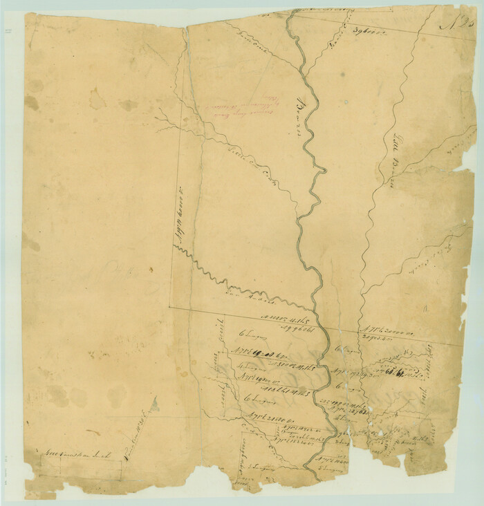
Print $20.00
- Digital $50.00
[Surveys in Austin's Colony along the Brazos River]
1833
Size: 25.0 x 23.9 inches
164
[Sketch of the Robertson League on the Brazos River showing a conflict with T.J. Chambers]
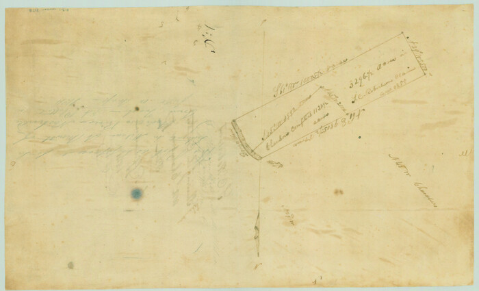
Print $2.00
- Digital $50.00
[Sketch of the Robertson League on the Brazos River showing a conflict with T.J. Chambers]
1841
Size: 7.6 x 12.6 inches
3178
[Map of the Location Survey of the Hearne & Brazos Valley Railroad]
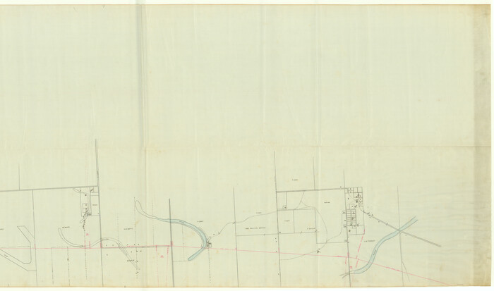
Print $40.00
- Digital $50.00
[Map of the Location Survey of the Hearne & Brazos Valley Railroad]
1891
Size: 38.4 x 65.1 inches
64348
[Map of the Line of the H. & Texas Cen. Railway from the Navasota River, 72 1/2 Miles from Houston, to Corsicana in Navarro Co., 211 mls from Houston]
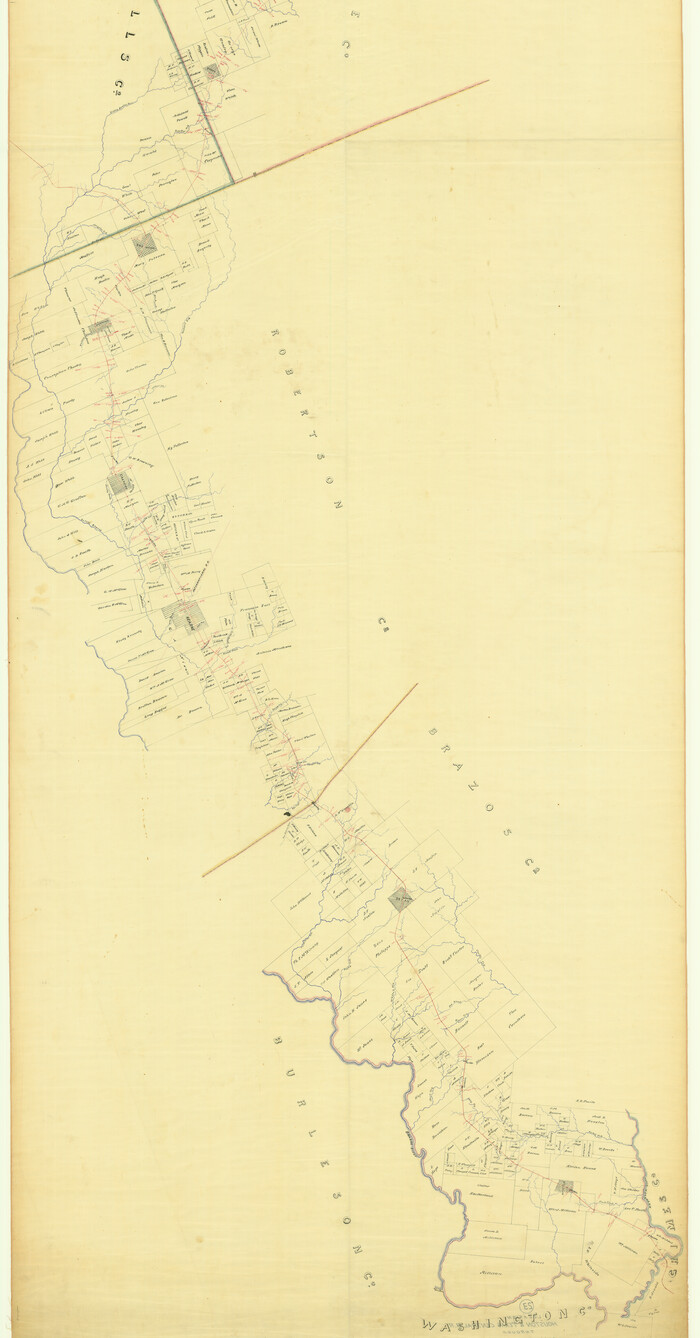
Print $40.00
- Digital $50.00
[Map of the Line of the H. & Texas Cen. Railway from the Navasota River, 72 1/2 Miles from Houston, to Corsicana in Navarro Co., 211 mls from Houston]
Size: 75.6 x 39.6 inches
64087
[Large surveys along the Navasota River]
Print $20.00
- Digital $50.00
[Large surveys along the Navasota River]
1840
Size: 24.5 x 14.3 inches
48
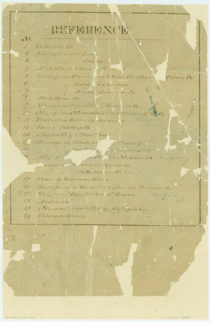
[Atlas C, Table of Contents]
Print $3.00
- Digital $50.00
[Atlas C, Table of Contents]
Size: 14.7 x 9.6 inches
78353
Wayland Crossing Sheet Robertson, Limestone and Leon Counties, Navasota River

Print $20.00
- Digital $50.00
Wayland Crossing Sheet Robertson, Limestone and Leon Counties, Navasota River
1934
Size: 43.9 x 40.9 inches
65072
University Lands Situated in Robertson County

Print $20.00
- Digital $50.00
University Lands Situated in Robertson County
1841
Size: 22.8 x 26.2 inches
281
The Republic County of Robertson. Spring 1842

Print $20.00
The Republic County of Robertson. Spring 1842
2020
Size: 16.9 x 21.7 inches
96263
The Republic County of Robertson. November 28, 1839

Print $20.00
The Republic County of Robertson. November 28, 1839
2020
Size: 18.9 x 21.6 inches
96260
The Republic County of Robertson. January 30, 1841

Print $20.00
The Republic County of Robertson. January 30, 1841
2020
Size: 16.9 x 21.7 inches
96261
The Republic County of Robertson. January 29, 1842

Print $20.00
The Republic County of Robertson. January 29, 1842
2020
Size: 16.9 x 21.7 inches
96262
The Republic County of Robertson. December 29, 1845

Print $20.00
The Republic County of Robertson. December 29, 1845
2020
Size: 16.9 x 21.7 inches
96264
The Republic County of Robertson. Created, December 14, 1837

Print $20.00
The Republic County of Robertson. Created, December 14, 1837
2020
Size: 18.9 x 21.6 inches
96259
Robertson County Working Sketch Graphic Index

Print $20.00
- Digital $50.00
Robertson County Working Sketch Graphic Index
1945
Size: 46.8 x 37.9 inches
76685
Robertson County Working Sketch 9

Print $20.00
- Digital $50.00
Robertson County Working Sketch 9
1984
Size: 19.9 x 21.5 inches
63582
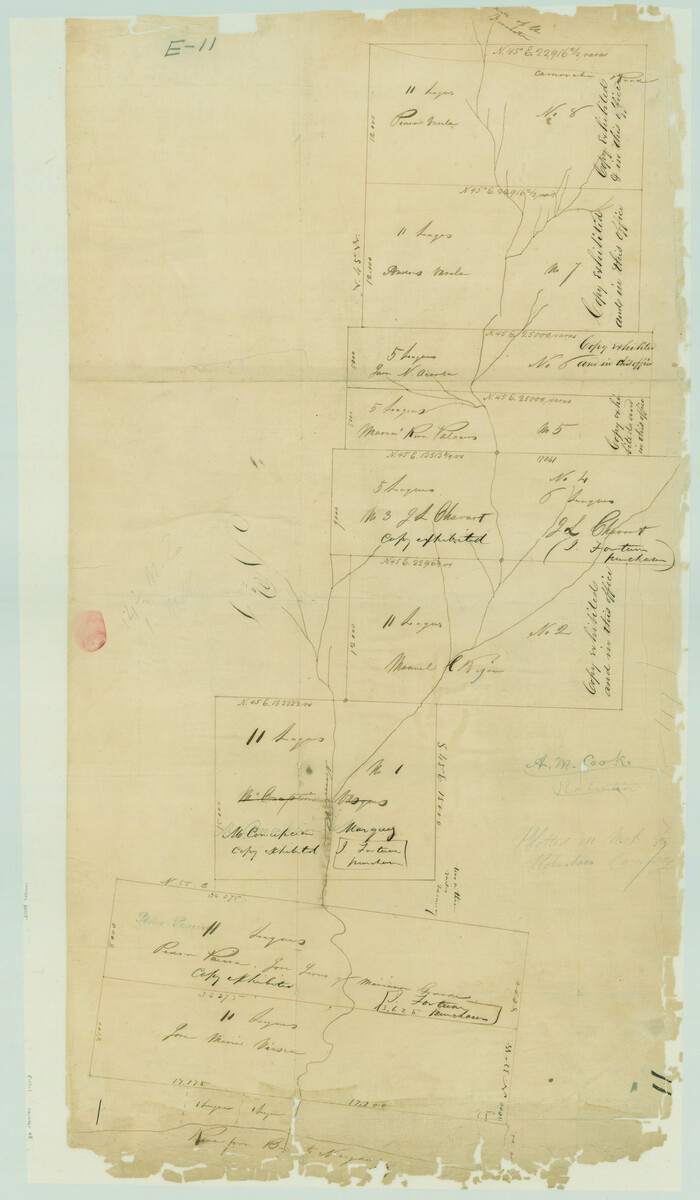
Robertson County Working Sketch 8

Print $20.00
- Digital $50.00
Robertson County Working Sketch 8
1983
Size: 36.7 x 38.7 inches
63581
Robertson County Working Sketch 7

Print $20.00
- Digital $50.00
Robertson County Working Sketch 7
1983
Size: 36.4 x 38.5 inches
63580
Robertson County Working Sketch 7

Print $20.00
- Digital $50.00
Robertson County Working Sketch 7
1983
Size: 36.6 x 38.3 inches
78228
Robertson County Working Sketch 6

Print $20.00
- Digital $50.00
Robertson County Working Sketch 6
1981
Size: 14.1 x 15.9 inches
63579
Robertson County Working Sketch 5

Print $20.00
- Digital $50.00
Robertson County Working Sketch 5
1980
Size: 33.9 x 44.1 inches
63578
Robertson County Working Sketch 4

Print $20.00
- Digital $50.00
Robertson County Working Sketch 4
1979
Size: 19.5 x 32.1 inches
63577
Robertson County Working Sketch 3

Print $20.00
- Digital $50.00
Robertson County Working Sketch 3
1969
Size: 36.5 x 30.8 inches
63576
Robertson County Working Sketch 21

Print $20.00
- Digital $50.00
Robertson County Working Sketch 21
2006
Size: 44.0 x 33.1 inches
84701
Robertson County Working Sketch 20

Print $40.00
- Digital $50.00
Robertson County Working Sketch 20
2005
Size: 27.5 x 50.0 inches
83583
Robertson County Working Sketch 2

Print $20.00
- Digital $50.00
Robertson County Working Sketch 2
1939
Size: 14.5 x 16.3 inches
63575
Robertson County Working Sketch 19

Print $20.00
- Digital $50.00
Robertson County Working Sketch 19
1996
Size: 35.9 x 46.7 inches
63592
Robertson County Working Sketch 18

Print $20.00
- Digital $50.00
Robertson County Working Sketch 18
1995
Size: 29.9 x 34.1 inches
63591
Robertson County Working Sketch 17

Print $20.00
- Digital $50.00
Robertson County Working Sketch 17
1991
Size: 16.8 x 22.9 inches
63590
[Surveys in Austin's Colony along the Brazos River]
Print $20.00
- Digital $50.00
[Surveys in Austin's Colony along the Brazos River]
1833
-
Size
25.0 x 23.9 inches
-
Map/Doc
164
-
Creation Date
1833
[Sketch of the Robertson League on the Brazos River showing a conflict with T.J. Chambers]
Print $2.00
- Digital $50.00
[Sketch of the Robertson League on the Brazos River showing a conflict with T.J. Chambers]
1841
-
Size
7.6 x 12.6 inches
-
Map/Doc
3178
-
Creation Date
1841
[Robertson Co.]
![4488, [Robertson Co.], Maddox Collection](https://historictexasmaps.com/wmedia_w700/maps/4488.tif.jpg)
Print $20.00
- Digital $50.00
[Robertson Co.]
1880
-
Size
32.3 x 44.3 inches
-
Map/Doc
4488
-
Creation Date
1880
[Map of the Location Survey of the Hearne & Brazos Valley Railroad]
Print $40.00
- Digital $50.00
[Map of the Location Survey of the Hearne & Brazos Valley Railroad]
1891
-
Size
38.4 x 65.1 inches
-
Map/Doc
64348
-
Creation Date
1891
[Map of the Line of the H. & Texas Cen. Railway from the Navasota River, 72 1/2 Miles from Houston, to Corsicana in Navarro Co., 211 mls from Houston]
Print $40.00
- Digital $50.00
[Map of the Line of the H. & Texas Cen. Railway from the Navasota River, 72 1/2 Miles from Houston, to Corsicana in Navarro Co., 211 mls from Houston]
-
Size
75.6 x 39.6 inches
-
Map/Doc
64087
[Large surveys along the Navasota River]
Print $20.00
- Digital $50.00
[Large surveys along the Navasota River]
1840
-
Size
24.5 x 14.3 inches
-
Map/Doc
48
-
Creation Date
1840
[Atlas C, Table of Contents]
Print $3.00
- Digital $50.00
[Atlas C, Table of Contents]
-
Size
14.7 x 9.6 inches
-
Map/Doc
78353
Wayland Crossing Sheet Robertson, Limestone and Leon Counties, Navasota River
Print $20.00
- Digital $50.00
Wayland Crossing Sheet Robertson, Limestone and Leon Counties, Navasota River
1934
-
Size
43.9 x 40.9 inches
-
Map/Doc
65072
-
Creation Date
1934
University Lands Situated in Robertson County
Print $20.00
- Digital $50.00
University Lands Situated in Robertson County
1841
-
Size
22.8 x 26.2 inches
-
Map/Doc
281
-
Creation Date
1841
The Republic County of Robertson. Spring 1842
Print $20.00
The Republic County of Robertson. Spring 1842
2020
-
Size
16.9 x 21.7 inches
-
Map/Doc
96263
-
Creation Date
2020
The Republic County of Robertson. November 28, 1839
Print $20.00
The Republic County of Robertson. November 28, 1839
2020
-
Size
18.9 x 21.6 inches
-
Map/Doc
96260
-
Creation Date
2020
The Republic County of Robertson. January 30, 1841
Print $20.00
The Republic County of Robertson. January 30, 1841
2020
-
Size
16.9 x 21.7 inches
-
Map/Doc
96261
-
Creation Date
2020
The Republic County of Robertson. January 29, 1842
Print $20.00
The Republic County of Robertson. January 29, 1842
2020
-
Size
16.9 x 21.7 inches
-
Map/Doc
96262
-
Creation Date
2020
The Republic County of Robertson. December 29, 1845
Print $20.00
The Republic County of Robertson. December 29, 1845
2020
-
Size
16.9 x 21.7 inches
-
Map/Doc
96264
-
Creation Date
2020
The Republic County of Robertson. Created, December 14, 1837
Print $20.00
The Republic County of Robertson. Created, December 14, 1837
2020
-
Size
18.9 x 21.6 inches
-
Map/Doc
96259
-
Creation Date
2020
Robertson County Working Sketch Graphic Index
Print $20.00
- Digital $50.00
Robertson County Working Sketch Graphic Index
1945
-
Size
46.8 x 37.9 inches
-
Map/Doc
76685
-
Creation Date
1945
Robertson County Working Sketch 9
Print $20.00
- Digital $50.00
Robertson County Working Sketch 9
1984
-
Size
19.9 x 21.5 inches
-
Map/Doc
63582
-
Creation Date
1984
Robertson County Working Sketch 8
Print $20.00
- Digital $50.00
Robertson County Working Sketch 8
1983
-
Size
36.7 x 38.7 inches
-
Map/Doc
63581
-
Creation Date
1983
Robertson County Working Sketch 7
Print $20.00
- Digital $50.00
Robertson County Working Sketch 7
1983
-
Size
36.4 x 38.5 inches
-
Map/Doc
63580
-
Creation Date
1983
Robertson County Working Sketch 7
Print $20.00
- Digital $50.00
Robertson County Working Sketch 7
1983
-
Size
36.6 x 38.3 inches
-
Map/Doc
78228
-
Creation Date
1983
Robertson County Working Sketch 6
Print $20.00
- Digital $50.00
Robertson County Working Sketch 6
1981
-
Size
14.1 x 15.9 inches
-
Map/Doc
63579
-
Creation Date
1981
Robertson County Working Sketch 5
Print $20.00
- Digital $50.00
Robertson County Working Sketch 5
1980
-
Size
33.9 x 44.1 inches
-
Map/Doc
63578
-
Creation Date
1980
Robertson County Working Sketch 4
Print $20.00
- Digital $50.00
Robertson County Working Sketch 4
1979
-
Size
19.5 x 32.1 inches
-
Map/Doc
63577
-
Creation Date
1979
Robertson County Working Sketch 3
Print $20.00
- Digital $50.00
Robertson County Working Sketch 3
1969
-
Size
36.5 x 30.8 inches
-
Map/Doc
63576
-
Creation Date
1969
Robertson County Working Sketch 21
Print $20.00
- Digital $50.00
Robertson County Working Sketch 21
2006
-
Size
44.0 x 33.1 inches
-
Map/Doc
84701
-
Creation Date
2006
Robertson County Working Sketch 20
Print $40.00
- Digital $50.00
Robertson County Working Sketch 20
2005
-
Size
27.5 x 50.0 inches
-
Map/Doc
83583
-
Creation Date
2005
Robertson County Working Sketch 2
Print $20.00
- Digital $50.00
Robertson County Working Sketch 2
1939
-
Size
14.5 x 16.3 inches
-
Map/Doc
63575
-
Creation Date
1939
Robertson County Working Sketch 19
Print $20.00
- Digital $50.00
Robertson County Working Sketch 19
1996
-
Size
35.9 x 46.7 inches
-
Map/Doc
63592
-
Creation Date
1996
Robertson County Working Sketch 18
Print $20.00
- Digital $50.00
Robertson County Working Sketch 18
1995
-
Size
29.9 x 34.1 inches
-
Map/Doc
63591
-
Creation Date
1995
Robertson County Working Sketch 17
Print $20.00
- Digital $50.00
Robertson County Working Sketch 17
1991
-
Size
16.8 x 22.9 inches
-
Map/Doc
63590
-
Creation Date
1991