Terry County Rolled Sketch 11

Print $20.00
- Digital $50.00
Terry County Rolled Sketch 11
2022
Size: 37.1 x 25.1 inches
97101
Terry County Rolled Sketch 10

Print $20.00
- Digital $50.00
Terry County Rolled Sketch 10
2001
Size: 25.2 x 23.8 inches
76414
Terry County Sketch File 20

Print $4.00
- Digital $50.00
Terry County Sketch File 20
2001
Size: 11.1 x 8.8 inches
76365
Terry County Sketch File 19

Print $6.00
- Digital $50.00
Terry County Sketch File 19
1998
Size: 11.2 x 8.9 inches
38047
Terry County Working Sketch Graphic Index

Print $20.00
- Digital $50.00
Terry County Working Sketch Graphic Index
1970
Size: 41.2 x 33.8 inches
76712
Hockley County Working Sketch 3

Print $20.00
- Digital $50.00
Hockley County Working Sketch 3
1962
Size: 35.4 x 22.0 inches
66193
General Highway Map, Terry County, Texas

Print $20.00
General Highway Map, Terry County, Texas
1961
Size: 18.1 x 24.9 inches
79675
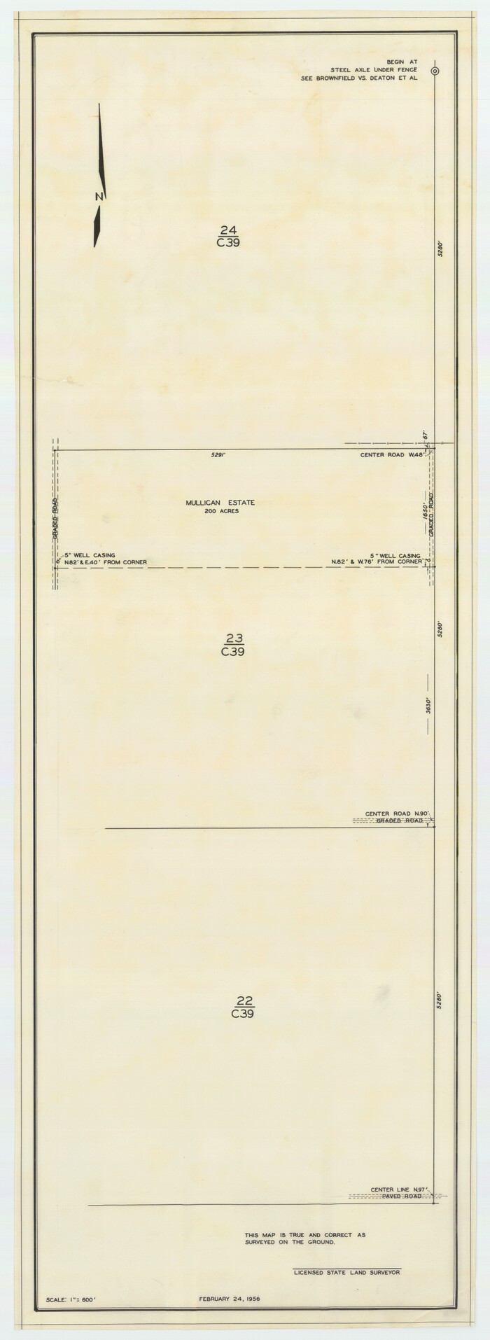
[Block C39, Sections 22, 23 Millican Estate, 24]
Print $20.00
- Digital $50.00
[Block C39, Sections 22, 23 Millican Estate, 24]
1956
Size: 11.4 x 31.2 inches
92345
Terry County Sketch File 17

Print $5.00
- Digital $50.00
Terry County Sketch File 17
1956
Size: 27.7 x 24.7 inches
12429
Gomez Section 1, Block D-12

Print $20.00
- Digital $50.00
Gomez Section 1, Block D-12
1955
Size: 15.8 x 16.8 inches
92321
Terry County Sketch

Print $20.00
- Digital $50.00
Terry County Sketch
1954
Size: 13.7 x 20.6 inches
92413
Terry County Working Sketch 3

Print $40.00
- Digital $50.00
Terry County Working Sketch 3
1953
Size: 125.9 x 28.4 inches
62108
Map of City of Brownfield, Texas

Print $20.00
- Digital $50.00
Map of City of Brownfield, Texas
1953
Size: 44.4 x 40.1 inches
89890
Terry County Working Sketch 2

Print $20.00
- Digital $50.00
Terry County Working Sketch 2
1952
Size: 19.3 x 19.3 inches
62107
Lynn County Rolled Sketch 14

Print $20.00
- Digital $50.00
Lynn County Rolled Sketch 14
1952
Size: 35.4 x 35.3 inches
9474
[Southwest Portion of Lynn County, Southeast Portion of Terry County]
Print $20.00
- Digital $50.00
[Southwest Portion of Lynn County, Southeast Portion of Terry County]
1952
Size: 34.3 x 35.1 inches
91305
Lynn County Working Sketch 2

Print $20.00
- Digital $50.00
Lynn County Working Sketch 2
1951
Size: 19.8 x 42.5 inches
70672
Map of Public Roads in Terry County, Texas

Print $2.00
- Digital $50.00
Map of Public Roads in Terry County, Texas
1951
Size: 9.1 x 11.6 inches
91937
Terry County Sketch File 3

Print $20.00
- Digital $50.00
Terry County Sketch File 3
1948
Size: 16.2 x 39.0 inches
10390
Texas Coordinate File 6

Print $40.00
- Digital $50.00
Texas Coordinate File 6
1946
Size: 23.7 x 49.0 inches
75314
Plat Compiled by W.J. Williams, Plainview, Texas, and Sylvan Sanders, Lubbock, Texas Showing Position of Original and Re-Survey Corners in Lynn, Terry, Yoakum, Gaines, and Dawson Counties, Texas

Print $40.00
- Digital $50.00
Plat Compiled by W.J. Williams, Plainview, Texas, and Sylvan Sanders, Lubbock, Texas Showing Position of Original and Re-Survey Corners in Lynn, Terry, Yoakum, Gaines, and Dawson Counties, Texas
1946
Size: 56.6 x 22.6 inches
89628
Showing Position of Original and Re-Survey Corners in Lynn, Terry, Yoakum, Gaines and Dawson Counties, Texas

Print $40.00
- Digital $50.00
Showing Position of Original and Re-Survey Corners in Lynn, Terry, Yoakum, Gaines and Dawson Counties, Texas
1946
Size: 57.3 x 22.1 inches
93044
Plat Compiled by W. J. Williams, Plainview, Texas, and Sylvan Sanders, Lubbock, Texas Showing Position of Original and Re-Survey Corners in Lynn, Terry, Yoakum, Gaines and Dawson Counties, Texas

Print $40.00
- Digital $50.00
Plat Compiled by W. J. Williams, Plainview, Texas, and Sylvan Sanders, Lubbock, Texas Showing Position of Original and Re-Survey Corners in Lynn, Terry, Yoakum, Gaines and Dawson Counties, Texas
1946
Size: 57.6 x 22.9 inches
89689
Sketch in Terry and Yoakum Counties

Print $20.00
- Digital $50.00
Sketch in Terry and Yoakum Counties
1945
Size: 20.7 x 38.5 inches
91939
Terry County Sketch File 16

Print $20.00
- Digital $50.00
Terry County Sketch File 16
1945
Size: 39.9 x 25.4 inches
10399
Terry County Rolled Sketch 6

Print $20.00
- Digital $50.00
Terry County Rolled Sketch 6
1944
Size: 36.5 x 43.7 inches
9996
Terry County Rolled Sketch 11
Print $20.00
- Digital $50.00
Terry County Rolled Sketch 11
2022
-
Size
37.1 x 25.1 inches
-
Map/Doc
97101
-
Creation Date
2022
Terry County Rolled Sketch 10
Print $20.00
- Digital $50.00
Terry County Rolled Sketch 10
2001
-
Size
25.2 x 23.8 inches
-
Map/Doc
76414
-
Creation Date
2001
Terry County Sketch File 20
Print $4.00
- Digital $50.00
Terry County Sketch File 20
2001
-
Size
11.1 x 8.8 inches
-
Map/Doc
76365
-
Creation Date
2001
Terry County Sketch File 19
Print $6.00
- Digital $50.00
Terry County Sketch File 19
1998
-
Size
11.2 x 8.9 inches
-
Map/Doc
38047
-
Creation Date
1998
Terry County

Print $20.00
- Digital $50.00
Terry County
1970
-
Size
42.6 x 35.1 inches
-
Map/Doc
73301
-
Creation Date
1970
Terry County

Print $20.00
- Digital $50.00
Terry County
1970
-
Size
43.1 x 35.3 inches
-
Map/Doc
95652
-
Creation Date
1970
Terry County Working Sketch Graphic Index
Print $20.00
- Digital $50.00
Terry County Working Sketch Graphic Index
1970
-
Size
41.2 x 33.8 inches
-
Map/Doc
76712
-
Creation Date
1970
Terry County

Print $20.00
- Digital $50.00
Terry County
1970
-
Size
41.0 x 33.5 inches
-
Map/Doc
77434
-
Creation Date
1970
Hockley County Working Sketch 3
Print $20.00
- Digital $50.00
Hockley County Working Sketch 3
1962
-
Size
35.4 x 22.0 inches
-
Map/Doc
66193
-
Creation Date
1962
General Highway Map, Terry County, Texas
Print $20.00
General Highway Map, Terry County, Texas
1961
-
Size
18.1 x 24.9 inches
-
Map/Doc
79675
-
Creation Date
1961
[Block C39, Sections 22, 23 Millican Estate, 24]
Print $20.00
- Digital $50.00
[Block C39, Sections 22, 23 Millican Estate, 24]
1956
-
Size
11.4 x 31.2 inches
-
Map/Doc
92345
-
Creation Date
1956
Terry County Sketch File 17
Print $5.00
- Digital $50.00
Terry County Sketch File 17
1956
-
Size
27.7 x 24.7 inches
-
Map/Doc
12429
-
Creation Date
1956
Gomez Section 1, Block D-12
Print $20.00
- Digital $50.00
Gomez Section 1, Block D-12
1955
-
Size
15.8 x 16.8 inches
-
Map/Doc
92321
-
Creation Date
1955
Terry County Sketch
Print $20.00
- Digital $50.00
Terry County Sketch
1954
-
Size
13.7 x 20.6 inches
-
Map/Doc
92413
-
Creation Date
1954
Terry County Working Sketch 3
Print $40.00
- Digital $50.00
Terry County Working Sketch 3
1953
-
Size
125.9 x 28.4 inches
-
Map/Doc
62108
-
Creation Date
1953
Map of City of Brownfield, Texas
Print $20.00
- Digital $50.00
Map of City of Brownfield, Texas
1953
-
Size
44.4 x 40.1 inches
-
Map/Doc
89890
-
Creation Date
1953
Terry County Working Sketch 2
Print $20.00
- Digital $50.00
Terry County Working Sketch 2
1952
-
Size
19.3 x 19.3 inches
-
Map/Doc
62107
-
Creation Date
1952
Lynn County Rolled Sketch 14
Print $20.00
- Digital $50.00
Lynn County Rolled Sketch 14
1952
-
Size
35.4 x 35.3 inches
-
Map/Doc
9474
-
Creation Date
1952
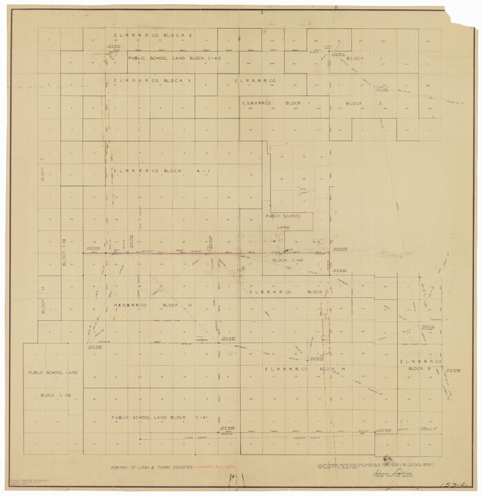
[Block 4X]
![92955, [Block 4X], Twichell Survey Records](https://historictexasmaps.com/wmedia_w700/maps/92955-1.tif.jpg)
Print $2.00
- Digital $50.00
[Block 4X]
1952
-
Size
9.8 x 7.8 inches
-
Map/Doc
92955
-
Creation Date
1952
[Southwest Portion of Lynn County, Southeast Portion of Terry County]
Print $20.00
- Digital $50.00
[Southwest Portion of Lynn County, Southeast Portion of Terry County]
1952
-
Size
34.3 x 35.1 inches
-
Map/Doc
91305
-
Creation Date
1952
Lynn County Working Sketch 2
Print $20.00
- Digital $50.00
Lynn County Working Sketch 2
1951
-
Size
19.8 x 42.5 inches
-
Map/Doc
70672
-
Creation Date
1951
Map of Public Roads in Terry County, Texas
Print $2.00
- Digital $50.00
Map of Public Roads in Terry County, Texas
1951
-
Size
9.1 x 11.6 inches
-
Map/Doc
91937
-
Creation Date
1951
Terry County Sketch File 3
Print $20.00
- Digital $50.00
Terry County Sketch File 3
1948
-
Size
16.2 x 39.0 inches
-
Map/Doc
10390
-
Creation Date
1948
Texas Coordinate File 6
Print $40.00
- Digital $50.00
Texas Coordinate File 6
1946
-
Size
23.7 x 49.0 inches
-
Map/Doc
75314
-
Creation Date
1946
Plat Compiled by W.J. Williams, Plainview, Texas, and Sylvan Sanders, Lubbock, Texas Showing Position of Original and Re-Survey Corners in Lynn, Terry, Yoakum, Gaines, and Dawson Counties, Texas
Print $40.00
- Digital $50.00
Plat Compiled by W.J. Williams, Plainview, Texas, and Sylvan Sanders, Lubbock, Texas Showing Position of Original and Re-Survey Corners in Lynn, Terry, Yoakum, Gaines, and Dawson Counties, Texas
1946
-
Size
56.6 x 22.6 inches
-
Map/Doc
89628
-
Creation Date
1946
Showing Position of Original and Re-Survey Corners in Lynn, Terry, Yoakum, Gaines and Dawson Counties, Texas
Print $40.00
- Digital $50.00
Showing Position of Original and Re-Survey Corners in Lynn, Terry, Yoakum, Gaines and Dawson Counties, Texas
1946
-
Size
57.3 x 22.1 inches
-
Map/Doc
93044
-
Creation Date
1946
Plat Compiled by W. J. Williams, Plainview, Texas, and Sylvan Sanders, Lubbock, Texas Showing Position of Original and Re-Survey Corners in Lynn, Terry, Yoakum, Gaines and Dawson Counties, Texas
Print $40.00
- Digital $50.00
Plat Compiled by W. J. Williams, Plainview, Texas, and Sylvan Sanders, Lubbock, Texas Showing Position of Original and Re-Survey Corners in Lynn, Terry, Yoakum, Gaines and Dawson Counties, Texas
1946
-
Size
57.6 x 22.9 inches
-
Map/Doc
89689
-
Creation Date
1946
Sketch in Terry and Yoakum Counties
Print $20.00
- Digital $50.00
Sketch in Terry and Yoakum Counties
1945
-
Size
20.7 x 38.5 inches
-
Map/Doc
91939
-
Creation Date
1945
Terry County Sketch File 16
Print $20.00
- Digital $50.00
Terry County Sketch File 16
1945
-
Size
39.9 x 25.4 inches
-
Map/Doc
10399
-
Creation Date
1945
Terry County Rolled Sketch 6
Print $20.00
- Digital $50.00
Terry County Rolled Sketch 6
1944
-
Size
36.5 x 43.7 inches
-
Map/Doc
9996
-
Creation Date
1944